You are here: Home > Network List > CD - China Digital Seismograph Network Stations List
> Station BJI Baijiatuan, Beijing, China > Earthquake Result Viewer
BJI Baijiatuan, Beijing, China - Earthquake Result Viewer
| Earthquake location: |
Philippine Islands Region |
| Earthquake latitude/longitude: |
5.1/127.7 |
| Earthquake time(UTC): |
1993/07/24 (205) 02:01:58 GMT |
| Earthquake Depth: |
129 km |
| Earthquake Magnitude: |
5.7 MB |
| Earthquake Catalog/Contributor: |
WHDF/NEIC |
|
| Network: |
CD China Digital Seismograph Network |
| Station: |
BJI Baijiatuan, Beijing, China |
| Lat/Lon: |
40.04 N/116.18 E |
| Elevation: |
43 m |
|
| Distance: |
36.3 deg |
| Az: |
345.031 deg |
| Baz: |
160.418 deg |
| Ray Param: |
0.07630712 |
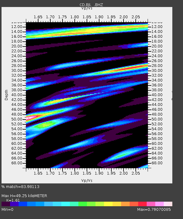
| Estimated Moho Depth: |
49.25 km |
| Estimated Crust Vp/Vs: |
1.61 |
| Assumed Crust Vp: |
6.464 km/s |
| Estimated Crust Vs: |
4.015 km/s |
| Estimated Crust Poisson's Ratio: |
0.19 |
|
| Radial Match: |
83.98113 % |
| Radial Bump: |
400 |
| Transverse Match: |
65.500404 % |
| Transverse Bump: |
400 |
| SOD ConfigId: |
4480 |
| Insert Time: |
2010-02-26 18:20:11.493 +0000 |
| GWidth: |
2.5 |
| Max Bumps: |
400 |
| Tol: |
0.001 |
|

Signal To Noise
| Channel | StoN | STA | LTA |
| CD:BJI: :BHZ:19930724T02:08:19.189014Z | 3.992589 | 8.392893E-7 | 2.1021181E-7 |
| CD:BJI: :BHN:19930724T02:08:19.189014Z | 1.5829744 | 4.7046362E-7 | 2.972023E-7 |
| CD:BJI: :BHE:19930724T02:08:19.189014Z | 1.2081238 | 4.113387E-7 | 3.4047727E-7 |
| Arrivals |
| Ps | 5.0 SECOND |
| PpPs | 18 SECOND |
| PsPs/PpSs | 23 SECOND |


