You are here: Home > Network List > CD - China Digital Seismograph Network Stations List
> Station BJI Baijiatuan, Beijing, China > Earthquake Result Viewer
BJI Baijiatuan, Beijing, China - Earthquake Result Viewer
| Earthquake location: |
South Of Mariana Islands |
| Earthquake latitude/longitude: |
13.0/144.8 |
| Earthquake time(UTC): |
1993/08/08 (220) 08:34:25 GMT |
| Earthquake Depth: |
61 km |
| Earthquake Magnitude: |
7.2 MB, 8.1 MS, 8.2 UNKNOWN, 7.5 MW |
| Earthquake Catalog/Contributor: |
WHDF/NEIC |
|
| Network: |
CD China Digital Seismograph Network |
| Station: |
BJI Baijiatuan, Beijing, China |
| Lat/Lon: |
40.04 N/116.18 E |
| Elevation: |
43 m |
|
| Distance: |
36.9 deg |
| Az: |
322.237 deg |
| Baz: |
128.957 deg |
| Ray Param: |
0.07627335 |
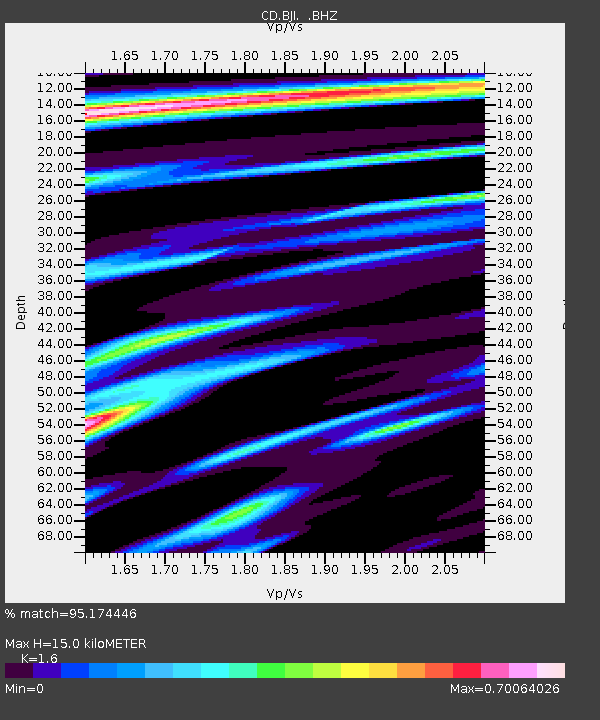
| Estimated Moho Depth: |
15.0 km |
| Estimated Crust Vp/Vs: |
1.60 |
| Assumed Crust Vp: |
6.464 km/s |
| Estimated Crust Vs: |
4.04 km/s |
| Estimated Crust Poisson's Ratio: |
0.18 |
|
| Radial Match: |
95.174446 % |
| Radial Bump: |
339 |
| Transverse Match: |
85.10358 % |
| Transverse Bump: |
400 |
| SOD ConfigId: |
4480 |
| Insert Time: |
2010-02-26 18:20:21.285 +0000 |
| GWidth: |
2.5 |
| Max Bumps: |
400 |
| Tol: |
0.001 |
|
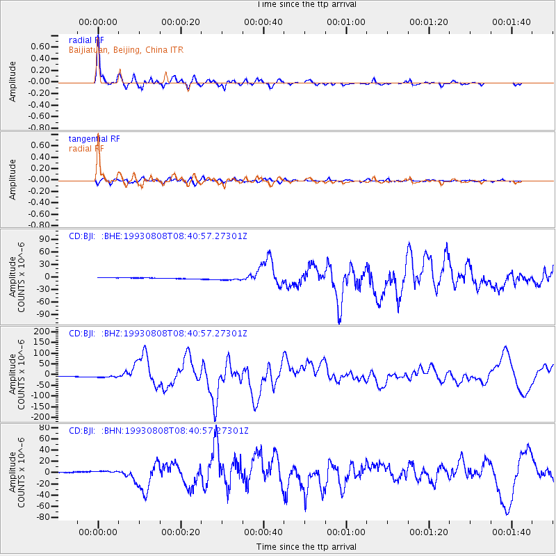
Signal To Noise
| Channel | StoN | STA | LTA |
| CD:BJI: :BHZ:19930808T08:40:57.27301Z | 2.9972095 | 6.8567906E-6 | 2.2877248E-6 |
| CD:BJI: :BHN:19930808T08:40:57.27301Z | 3.17578 | 2.894548E-6 | 9.114448E-7 |
| CD:BJI: :BHE:19930808T08:40:57.27301Z | 3.3556702 | 4.0119894E-6 | 1.1955851E-6 |
| Arrivals |
| Ps | 1.5 SECOND |
| PpPs | 5.6 SECOND |
| PsPs/PpSs | 7.1 SECOND |


