You are here: Home > Network List > CD - China Digital Seismograph Network Stations List
> Station BJI Baijiatuan, Beijing, China > Earthquake Result Viewer
BJI Baijiatuan, Beijing, China - Earthquake Result Viewer
| Earthquake location: |
Hindu Kush Region, Afghanistan |
| Earthquake latitude/longitude: |
36.4/70.7 |
| Earthquake time(UTC): |
1993/08/09 (221) 11:38:31 GMT |
| Earthquake Depth: |
210 km |
| Earthquake Magnitude: |
5.8 MB, 6.3 UNKNOWN, 6.2 MW |
| Earthquake Catalog/Contributor: |
WHDF/NEIC |
|
| Network: |
CD China Digital Seismograph Network |
| Station: |
BJI Baijiatuan, Beijing, China |
| Lat/Lon: |
40.04 N/116.18 E |
| Elevation: |
43 m |
|
| Distance: |
35.6 deg |
| Az: |
70.054 deg |
| Baz: |
279.015 deg |
| Ray Param: |
0.07635969 |
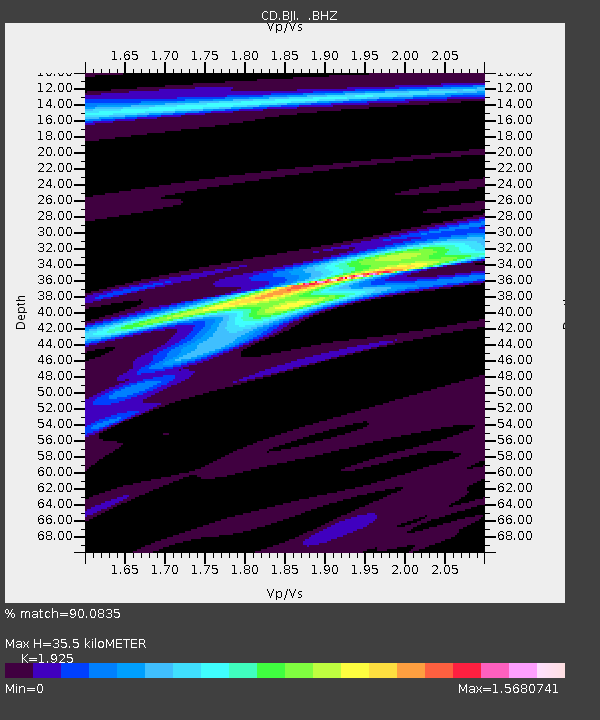
| Estimated Moho Depth: |
35.5 km |
| Estimated Crust Vp/Vs: |
1.92 |
| Assumed Crust Vp: |
6.464 km/s |
| Estimated Crust Vs: |
3.358 km/s |
| Estimated Crust Poisson's Ratio: |
0.32 |
|
| Radial Match: |
90.0835 % |
| Radial Bump: |
247 |
| Transverse Match: |
68.79054 % |
| Transverse Bump: |
400 |
| SOD ConfigId: |
4480 |
| Insert Time: |
2010-02-26 18:20:22.546 +0000 |
| GWidth: |
2.5 |
| Max Bumps: |
400 |
| Tol: |
0.001 |
|
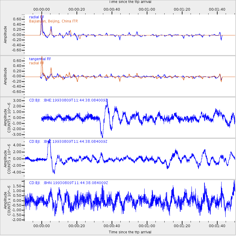
Signal To Noise
| Channel | StoN | STA | LTA |
| CD:BJI: :BHZ:19930809T11:44:38.084009Z | 8.736468 | 2.6005523E-6 | 2.9766633E-7 |
| CD:BJI: :BHN:19930809T11:44:38.084009Z | 1.0193009 | 3.8485513E-7 | 3.7756772E-7 |
| CD:BJI: :BHE:19930809T11:44:38.084009Z | 4.4510894 | 1.4088232E-6 | 3.16512E-7 |
| Arrivals |
| Ps | 5.4 SECOND |
| PpPs | 15 SECOND |
| PsPs/PpSs | 20 SECOND |


