You are here: Home > Network List > CD - China Digital Seismograph Network Stations List
> Station BJI Baijiatuan, Beijing, China > Earthquake Result Viewer
BJI Baijiatuan, Beijing, China - Earthquake Result Viewer
| Earthquake location: |
Hindu Kush Region, Afghanistan |
| Earthquake latitude/longitude: |
36.4/70.9 |
| Earthquake time(UTC): |
1993/08/09 (221) 12:42:49 GMT |
| Earthquake Depth: |
230 km |
| Earthquake Magnitude: |
6.3 MB, 6.9 UNKNOWN |
| Earthquake Catalog/Contributor: |
WHDF/NEIC |
|
| Network: |
CD China Digital Seismograph Network |
| Station: |
BJI Baijiatuan, Beijing, China |
| Lat/Lon: |
40.04 N/116.18 E |
| Elevation: |
43 m |
|
| Distance: |
35.5 deg |
| Az: |
70.007 deg |
| Baz: |
278.86 deg |
| Ray Param: |
0.07631587 |
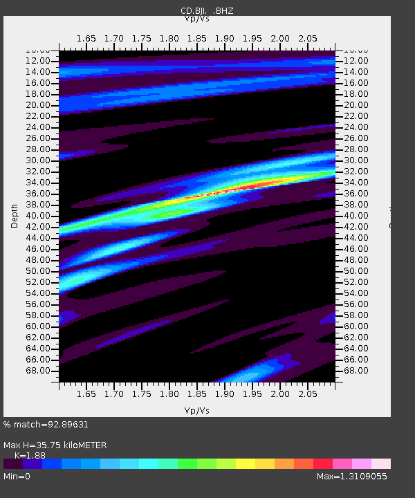
| Estimated Moho Depth: |
35.75 km |
| Estimated Crust Vp/Vs: |
1.88 |
| Assumed Crust Vp: |
6.464 km/s |
| Estimated Crust Vs: |
3.438 km/s |
| Estimated Crust Poisson's Ratio: |
0.30 |
|
| Radial Match: |
92.89631 % |
| Radial Bump: |
268 |
| Transverse Match: |
80.64246 % |
| Transverse Bump: |
400 |
| SOD ConfigId: |
4480 |
| Insert Time: |
2010-02-26 18:20:23.599 +0000 |
| GWidth: |
2.5 |
| Max Bumps: |
400 |
| Tol: |
0.001 |
|
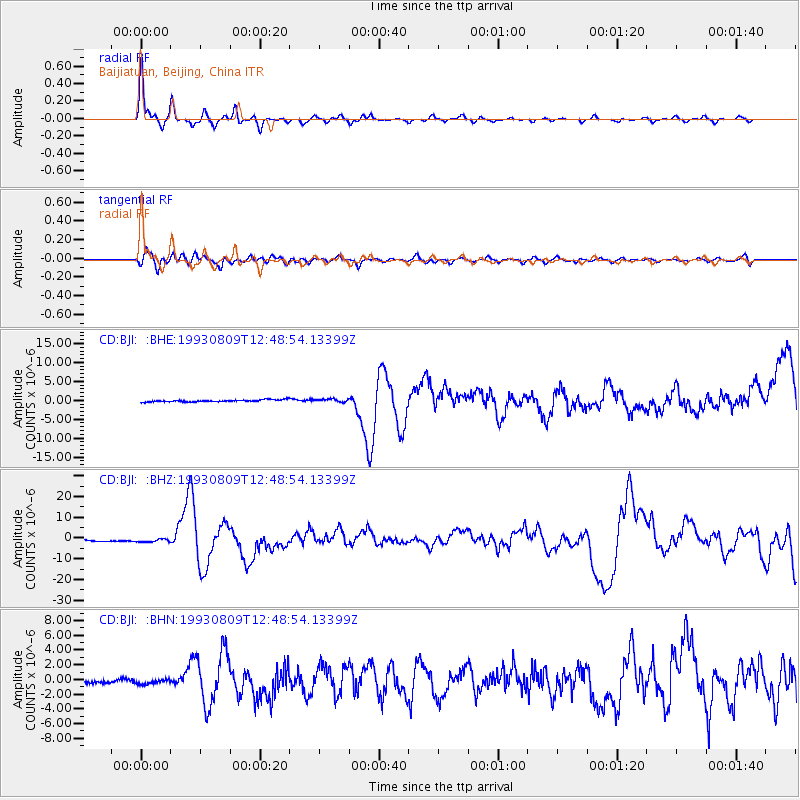
Signal To Noise
| Channel | StoN | STA | LTA |
| CD:BJI: :BHZ:19930809T12:48:54.13399Z | 2.1924982 | 7.511139E-7 | 3.4258355E-7 |
| CD:BJI: :BHN:19930809T12:48:54.13399Z | 1.5092815 | 3.0834508E-7 | 2.0429924E-7 |
| CD:BJI: :BHE:19930809T12:48:54.13399Z | 1.40387 | 3.909705E-7 | 2.784948E-7 |
| Arrivals |
| Ps | 5.2 SECOND |
| PpPs | 15 SECOND |
| PsPs/PpSs | 20 SECOND |


