You are here: Home > Network List > CD - China Digital Seismograph Network Stations List
> Station BJI Baijiatuan, Beijing, China > Earthquake Result Viewer
BJI Baijiatuan, Beijing, China - Earthquake Result Viewer
| Earthquake location: |
Nicobar Islands, India Region |
| Earthquake latitude/longitude: |
6.5/94.7 |
| Earthquake time(UTC): |
1993/08/28 (240) 20:14:44 GMT |
| Earthquake Depth: |
120 km |
| Earthquake Magnitude: |
5.8 MB, 5.9 UNKNOWN, 5.9 MW |
| Earthquake Catalog/Contributor: |
WHDF/NEIC |
|
| Network: |
CD China Digital Seismograph Network |
| Station: |
BJI Baijiatuan, Beijing, China |
| Lat/Lon: |
40.04 N/116.18 E |
| Elevation: |
43 m |
|
| Distance: |
38.5 deg |
| Az: |
26.795 deg |
| Baz: |
215.692 deg |
| Ray Param: |
0.07509534 |
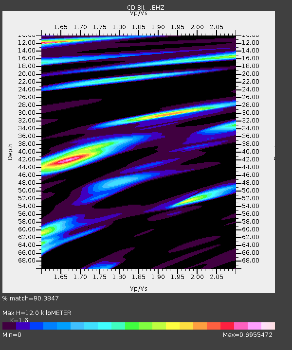
| Estimated Moho Depth: |
12.0 km |
| Estimated Crust Vp/Vs: |
1.60 |
| Assumed Crust Vp: |
6.464 km/s |
| Estimated Crust Vs: |
4.04 km/s |
| Estimated Crust Poisson's Ratio: |
0.18 |
|
| Radial Match: |
90.3847 % |
| Radial Bump: |
400 |
| Transverse Match: |
73.79442 % |
| Transverse Bump: |
400 |
| SOD ConfigId: |
4480 |
| Insert Time: |
2010-02-26 18:20:30.959 +0000 |
| GWidth: |
2.5 |
| Max Bumps: |
400 |
| Tol: |
0.001 |
|
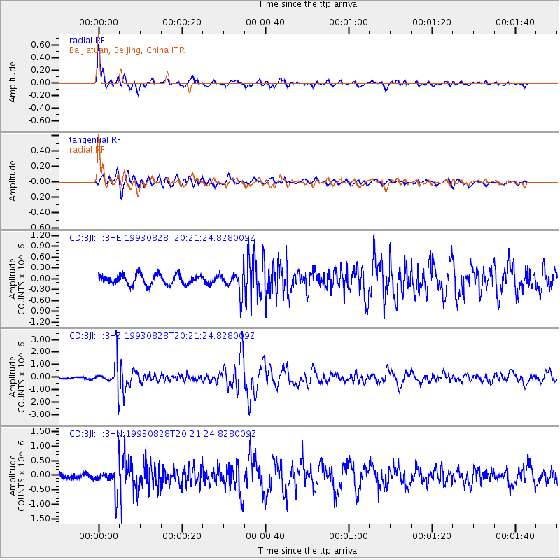
Signal To Noise
| Channel | StoN | STA | LTA |
| CD:BJI: :BHZ:19930828T20:21:24.828009Z | 12.915423 | 1.2100976E-6 | 9.3694E-8 |
| CD:BJI: :BHN:19930828T20:21:24.828009Z | 3.7277925 | 4.628637E-7 | 1.2416564E-7 |
| CD:BJI: :BHE:19930828T20:21:24.828009Z | 2.291451 | 3.1319664E-7 | 1.3668048E-7 |
| Arrivals |
| Ps | 1.2 SECOND |
| PpPs | 4.5 SECOND |
| PsPs/PpSs | 5.7 SECOND |


