You are here: Home > Network List > CD - China Digital Seismograph Network Stations List
> Station BJI Baijiatuan, Beijing, China > Earthquake Result Viewer
BJI Baijiatuan, Beijing, China - Earthquake Result Viewer
| Earthquake location: |
Banda Sea |
| Earthquake latitude/longitude: |
-7.0/129.5 |
| Earthquake time(UTC): |
1993/08/29 (241) 09:57:49 GMT |
| Earthquake Depth: |
99 km |
| Earthquake Magnitude: |
5.7 MB |
| Earthquake Catalog/Contributor: |
WHDF/NEIC |
|
| Network: |
CD China Digital Seismograph Network |
| Station: |
BJI Baijiatuan, Beijing, China |
| Lat/Lon: |
40.04 N/116.18 E |
| Elevation: |
43 m |
|
| Distance: |
48.4 deg |
| Az: |
346.272 deg |
| Baz: |
162.129 deg |
| Ray Param: |
0.06907517 |
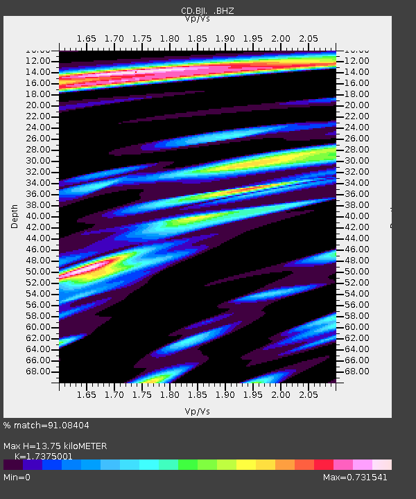
| Estimated Moho Depth: |
13.75 km |
| Estimated Crust Vp/Vs: |
1.74 |
| Assumed Crust Vp: |
6.464 km/s |
| Estimated Crust Vs: |
3.72 km/s |
| Estimated Crust Poisson's Ratio: |
0.25 |
|
| Radial Match: |
91.08404 % |
| Radial Bump: |
400 |
| Transverse Match: |
75.94511 % |
| Transverse Bump: |
400 |
| SOD ConfigId: |
4480 |
| Insert Time: |
2010-02-26 18:20:32.476 +0000 |
| GWidth: |
2.5 |
| Max Bumps: |
400 |
| Tol: |
0.001 |
|
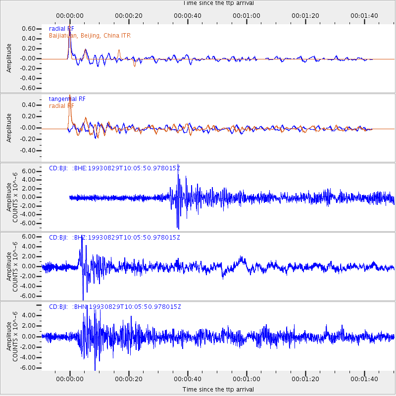
Signal To Noise
| Channel | StoN | STA | LTA |
| CD:BJI: :BHZ:19930829T10:05:50.978015Z | 3.8191316 | 1.9440495E-6 | 5.090292E-7 |
| CD:BJI: :BHN:19930829T10:05:50.978015Z | 3.0644588 | 1.358528E-6 | 4.4331742E-7 |
| CD:BJI: :BHE:19930829T10:05:50.978015Z | 2.8145776 | 8.8247947E-7 | 3.1353886E-7 |
| Arrivals |
| Ps | 1.7 SECOND |
| PpPs | 5.5 SECOND |
| PsPs/PpSs | 7.1 SECOND |


