You are here: Home > Network List > IC - New China Digital Seismograph Network Stations List
> Station HIA Hailar, Neimenggu Autonomous Region, China > Earthquake Result Viewer
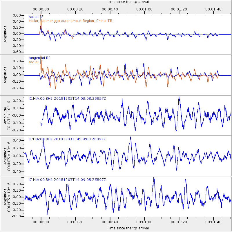
HIA Hailar, Neimenggu Autonomous Region, China - Earthquake Result Viewer
*The percent match for this event was below the threshold and hence no stack was calculated.
| Earthquake location: |
Banda Sea |
| Earthquake latitude/longitude: |
-7.4/128.8 |
| Earthquake time(UTC): |
2018/12/03 (337) 14:00:08 GMT |
| Earthquake Depth: |
141 km |
| Earthquake Magnitude: |
5.4 Mww |
| Earthquake Catalog/Contributor: |
NEIC PDE/us |
|
| Network: |
IC New China Digital Seismograph Network |
| Station: |
HIA Hailar, Neimenggu Autonomous Region, China |
| Lat/Lon: |
49.27 N/119.74 E |
| Elevation: |
620 m |
|
| Distance: |
57.0 deg |
| Az: |
352.964 deg |
| Baz: |
169.311 deg |
| Ray Param: |
$rayparam |
*The percent match for this event was below the threshold and hence was not used in the summary stack. |
|
| Radial Match: |
63.142628 % |
| Radial Bump: |
309 |
| Transverse Match: |
59.569977 % |
| Transverse Bump: |
317 |
| SOD ConfigId: |
3165032 |
| Insert Time: |
2018-12-17 14:12:07.395 +0000 |
| GWidth: |
2.5 |
| Max Bumps: |
400 |
| Tol: |
0.001 |
|
Signal To Noise
| Channel | StoN | STA | LTA |
| IC:HIA:00:BHZ:20181203T14:09:08.26897Z | 2.5987618 | 2.2937918E-7 | 8.8264805E-8 |
| IC:HIA:00:BH1:20181203T14:09:08.26897Z | 2.2900763 | 1.05691555E-7 | 4.6151982E-8 |
| IC:HIA:00:BH2:20181203T14:09:08.26897Z | 0.8302327 | 5.6900316E-8 | 6.8535385E-8 |
| Arrivals |
| Ps | |
| PpPs | |
| PsPs/PpSs | |


