You are here: Home > Network List > IC - New China Digital Seismograph Network Stations List
> Station HIA Hailar, Neimenggu Autonomous Region, China > Earthquake Result Viewer
HIA Hailar, Neimenggu Autonomous Region, China - Earthquake Result Viewer

| Earthquake location: |
Southeast Of Loyalty Islands |
| Earthquake latitude/longitude: |
-22.0/169.4 |
| Earthquake time(UTC): |
2018/12/05 (339) 04:18:08 GMT |
| Earthquake Depth: |
10 km |
| Earthquake Magnitude: |
7.5 Mww |
| Earthquake Catalog/Contributor: |
NEIC PDE/us |
|
| Network: |
IC New China Digital Seismograph Network |
| Station: |
HIA Hailar, Neimenggu Autonomous Region, China |
| Lat/Lon: |
49.27 N/119.74 E |
| Elevation: |
620 m |
|
| Distance: |
83.6 deg |
| Az: |
329.817 deg |
| Baz: |
134.561 deg |
| Ray Param: |
0.046101663 |
| Estimated Moho Depth: |
37.25 km |
| Estimated Crust Vp/Vs: |
1.68 |
| Assumed Crust Vp: |
6.577 km/s |
| Estimated Crust Vs: |
3.921 km/s |
| Estimated Crust Poisson's Ratio: |
0.22 |
|
| Radial Match: |
98.24017 % |
| Radial Bump: |
351 |
| Transverse Match: |
91.994354 % |
| Transverse Bump: |
400 |
| SOD ConfigId: |
3201911 |
| Insert Time: |
2018-12-19 04:24:32.048 +0000 |
| GWidth: |
2.5 |
| Max Bumps: |
400 |
| Tol: |
0.001 |
|
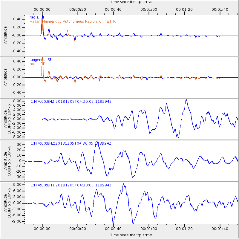
Signal To Noise
| Channel | StoN | STA | LTA |
| IC:HIA:00:BHZ:20181205T04:30:05.118994Z | 14.0439205 | 2.9052164E-6 | 2.0686647E-7 |
| IC:HIA:00:BH1:20181205T04:30:05.118994Z | 3.841804 | 7.631186E-7 | 1.9863548E-7 |
| IC:HIA:00:BH2:20181205T04:30:05.118994Z | 4.256113 | 8.4059576E-7 | 1.9750317E-7 |
| Arrivals |
| Ps | 3.9 SECOND |
| PpPs | 15 SECOND |
| PsPs/PpSs | 19 SECOND |


