You are here: Home > Network List > OE - Austrian Seismic Network Stations List
> Station DAVA Damuels, Vorarlberg, Austria > Earthquake Result Viewer
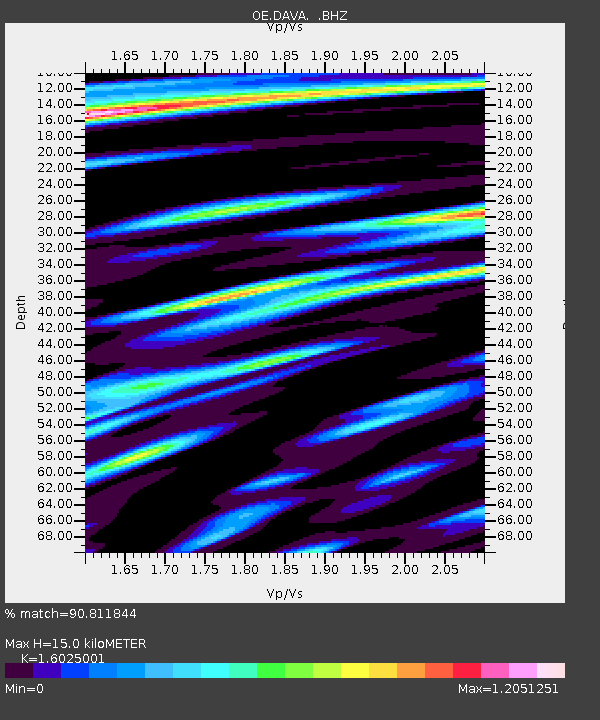
DAVA Damuels, Vorarlberg, Austria - Earthquake Result Viewer
| Earthquake location: |
Near East Coast Of Honshu, Japan |
| Earthquake latitude/longitude: |
39.7/142.4 |
| Earthquake time(UTC): |
2010/07/04 (185) 21:55:51 GMT |
| Earthquake Depth: |
27 km |
| Earthquake Magnitude: |
6.4 MB, 6.1 MS, 6.3 MW, 6.2 MW |
| Earthquake Catalog/Contributor: |
WHDF/NEIC |
|
| Network: |
OE Austrian Seismic Network |
| Station: |
DAVA Damuels, Vorarlberg, Austria |
| Lat/Lon: |
47.29 N/9.88 E |
| Elevation: |
1602 m |
|
| Distance: |
83.6 deg |
| Az: |
329.658 deg |
| Baz: |
34.924 deg |
| Ray Param: |
0.046030473 |
| Estimated Moho Depth: |
15.0 km |
| Estimated Crust Vp/Vs: |
1.60 |
| Assumed Crust Vp: |
6.416 km/s |
| Estimated Crust Vs: |
4.004 km/s |
| Estimated Crust Poisson's Ratio: |
0.18 |
|
| Radial Match: |
90.811844 % |
| Radial Bump: |
400 |
| Transverse Match: |
89.987305 % |
| Transverse Bump: |
400 |
| SOD ConfigId: |
319893 |
| Insert Time: |
2011-01-05 00:09:48.590 +0000 |
| GWidth: |
2.5 |
| Max Bumps: |
400 |
| Tol: |
0.001 |
|

Signal To Noise
| Channel | StoN | STA | LTA |
| OE:DAVA: :BHZ:20100704T22:07:46.560994Z | 23.255733 | 2.176584E-6 | 9.359344E-8 |
| OE:DAVA: :BHN:20100704T22:07:46.560994Z | 8.715976 | 7.754737E-7 | 8.897153E-8 |
| OE:DAVA: :BHE:20100704T22:07:46.560994Z | 4.260861 | 4.6460676E-7 | 1.0904058E-7 |
| Arrivals |
| Ps | 1.4 SECOND |
| PpPs | 5.9 SECOND |
| PsPs/PpSs | 7.4 SECOND |


