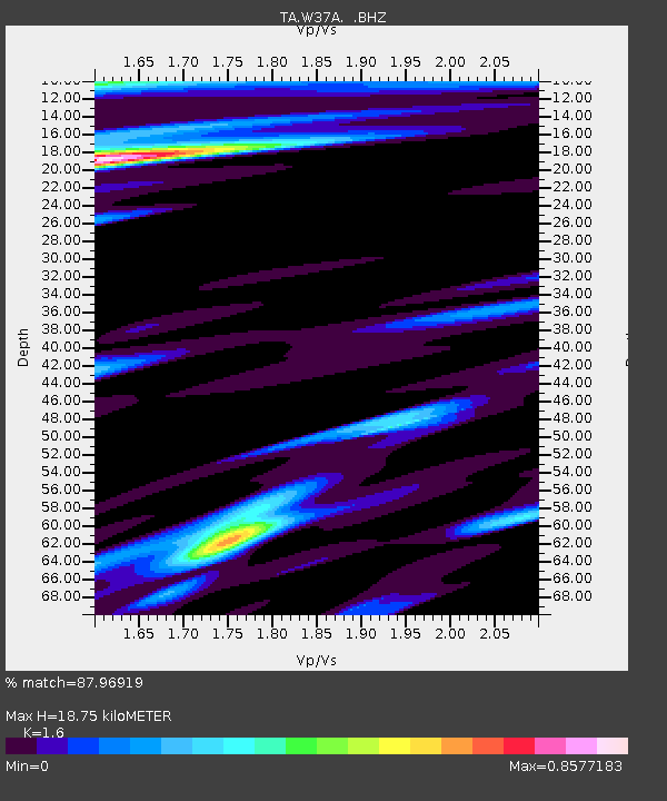
W37A Quinton, OK, USA - Earthquake Result Viewer
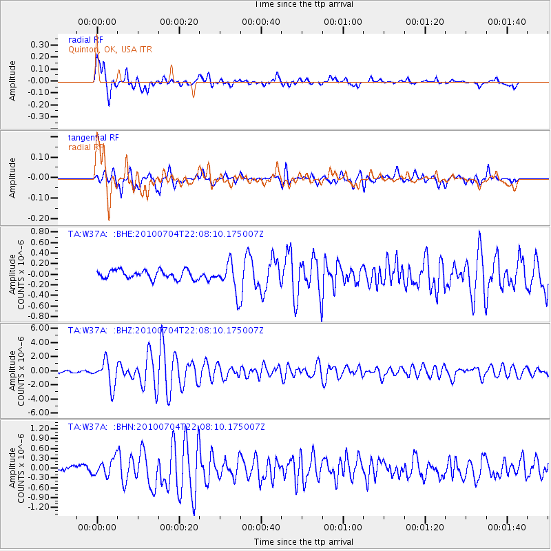
Earthquake location: Near East Coast Of Honshu, Japan
Earthquake latitude/longitude: 39.7/142.4
Earthquake time(UTC): 2010/07/04 (185) 21:55:51 GMT
Earthquake Depth: 27 km
Earthquake Magnitude: 6.4 MB, 6.1 MS, 6.3 MW, 6.2 MW
Earthquake Catalog/Contributor: WHDF/NEIC
Network: TA USArray Transportable Network (new EarthScope stations)
Station: W37A Quinton, OK, USA
Lat/Lon: 35.14 N/95.43 W
Elevation: 281 m
Distance: 88.4 deg
Az: 43.928 deg
Baz: 319.225 deg
Ray Param: 0.04256684
Estimated Moho Depth: 18.75 km
Estimated Crust Vp/Vs: 1.60
Assumed Crust Vp: 6.498 km/s
Estimated Crust Vs: 4.061 km/s
Estimated Crust Poisson's Ratio: 0.18
Radial Match: 87.96919 %
Radial Bump: 400
Transverse Match: 87.61629 %
Transverse Bump: 400
SOD ConfigId: 319893
Insert Time: 2011-01-05 00:38:05.975 +0000
GWidth: 2.5
Max Bumps: 400
Tol: 0.001

Signal To Noise

ChannelStoNSTALTA
TA:W37A: :BHZ:20100704T22:08:10.175007Z18.3079191.8686076E-61.02065535E-7
TA:W37A: :BHN:20100704T22:08:10.175007Z2.01050852.6317596E-71.309002E-7
TA:W37A: :BHE:20100704T22:08:10.175007Z3.62276652.9896816E-78.252483E-8
Arrivals
Ps1.8 SECOND
PpPs7.3 SECOND
PsPs/PpSs9.1 SECOND