You are here: Home > Network List > XA97 - Anatomy of an Archean Craton, South Africa Stations List
> Station SA59 XA.SA59 > Earthquake Result Viewer
SA59 XA.SA59 - Earthquake Result Viewer
| Earthquake location: |
Balleny Islands Region |
| Earthquake latitude/longitude: |
-62.9/149.5 |
| Earthquake time(UTC): |
1998/03/25 (084) 03:12:25 GMT |
| Earthquake Depth: |
10 km |
| Earthquake Magnitude: |
6.6 MB, 8.0 MS, 8.3 UNKNOWN, 8.1 MW |
| Earthquake Catalog/Contributor: |
WHDF/NEIC |
|
| Network: |
XA Anatomy of an Archean Craton, South Africa |
| Station: |
SA59 XA.SA59 |
| Lat/Lon: |
24.84 S/24.46 E |
| Elevation: |
1137 m |
|
| Distance: |
82.4 deg |
| Az: |
228.613 deg |
| Baz: |
157.761 deg |
| Ray Param: |
0.046904784 |
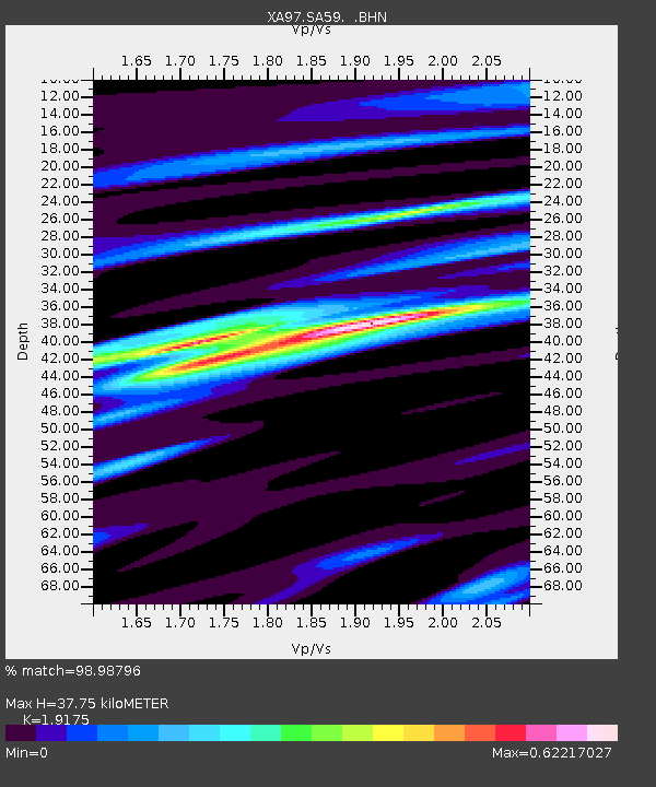
| Estimated Moho Depth: |
37.75 km |
| Estimated Crust Vp/Vs: |
1.92 |
| Assumed Crust Vp: |
6.459 km/s |
| Estimated Crust Vs: |
3.369 km/s |
| Estimated Crust Poisson's Ratio: |
0.31 |
|
| Radial Match: |
98.98796 % |
| Radial Bump: |
227 |
| Transverse Match: |
93.323784 % |
| Transverse Bump: |
400 |
| SOD ConfigId: |
6273 |
| Insert Time: |
2010-02-26 18:25:26.737 +0000 |
| GWidth: |
2.5 |
| Max Bumps: |
400 |
| Tol: |
0.001 |
|
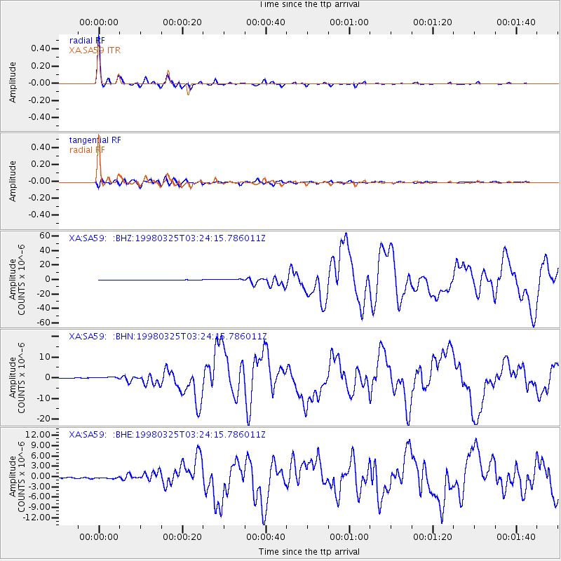
Signal To Noise
| Channel | StoN | STA | LTA |
| XA:SA59: :BHN:19980325T03:24:15.786011Z | 2.940194 | 5.438439E-7 | 1.8496873E-7 |
| XA:SA59: :BHE:19980325T03:24:15.786011Z | 2.0905917 | 2.3385505E-7 | 1.1186069E-7 |
| XA:SA59: :BHZ:19980325T03:24:15.786011Z | 4.4871197 | 1.086578E-6 | 2.421549E-7 |
| Arrivals |
| Ps | 5.5 SECOND |
| PpPs | 17 SECOND |
| PsPs/PpSs | 22 SECOND |


