
Station XA SA59 - XA.SA59
Network: XA97 - Anatomy of an Archean Craton, South Africa
Nearby stations (2 deg radius)
| Station | Name | (Lat, Lon) | Start / End | Elevation |
| SA59 | XA.SA59 | (-24.84, 24.46) | 1997-04-23 / 1999-12-31 | 1137 m |
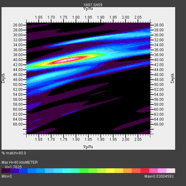
| Crust2 Type: | G1,Archean, no seds. |
| Thickness Estimate: | 40 km |
| Thickness StdDev: | 1.1 km |
| Vp/Vs Estimate: | 1.76 |
| Vp/Vs StdDev: | 0.03 |
| Vs Estimate: | 3.665 km/s |
| Poisson's Ratio: | 0.26 |
| Peak Value: | 0.03 |
| Assumed Vp: | 6.459 km/s |
| Ps Weight: | 0.33333334 |
| PpPs Weight: | 0.33333334 |
| PsPs Weight: | 0.33333328 |
| Residual Complexity: | 0.540 |
| Nearby stations H: | +- |
| (2.0 deg) Vp/Vs: | +- |
5 with match > 90% ( 22.727272 %) and 9 with match > 80% ( 40.909092 %) out of 22.
Download stack as xyz text file.
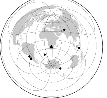
Azimuth Distribution of Events:
Prior Results for this Station
| Study | Thickness | Vp/Vs | Vp | Vs | Poissons Ratio | Extra |
| EARS | 40 km | 1.76 | 6.459 km/s | 3.665 km/s | 0.26 | |
| Crust2.0 | 37 km | 1.76 | 6.459 km/s | 3.665 km/s | 0.26 | G1,Archean, no seds. |
| Global Maxima | 40 km | 1.76 | 6.459 km/s | 3.665 km/s | 0.26 | amp=0.03004593 |
| Local Maxima 1 | 31 km | 1.90 | 6.459 km/s | 3.395 km/s | 0.31 | amp=0.012539872 |
| Local Maxima 2 | 42 km | 1.62 | 6.459 km/s | 3.981 km/s | 0.19 | amp=0.01039496 |
| Local Maxima 3 | 38 km | 1.82 | 6.459 km/s | 3.549 km/s | 0.28 | amp=0.009340968 |
| Local Maxima 4 | 40 km | 1.91 | 6.459 km/s | 3.373 km/s | 0.31 | amp=0.009012125 |
| Predicted Arrivals for vertical incidence (zero ray parameter) | |
| Ps | 4.72 SECOND |
| PpPs | 17.11 SECOND |
| PsPs/PpSs | 21.83 SECOND |
Events Processed for this Station
Download zip of receiver functions as SAC
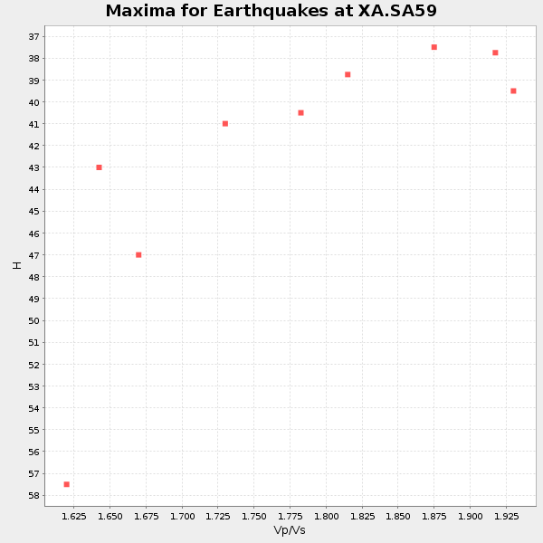
Plot maxima for each earthquake.
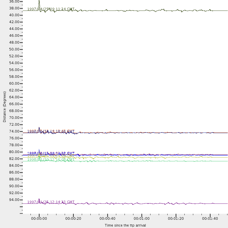
Events Used in the Stack
(9 events)| Radial Match | Distance | Baz | FERegion | Time | Lat/Lon | Depth | Magnitude |
| 98.98796 | 82.4 deg | 157.761 deg | Balleny Islands Region | 1998/03/25 03:12:25 GMT | (-62.9, 149.5) | 10 km | 6.6 MB, 8.0 MS, 8.3 UNKNOWN, 8.1 MW |
| 97.71979 | 82.2 deg | 239.669 deg | Near Coast Of Central Chile | 1997/10/15 01:03:33 GMT | (-30.9, -71.2) | 58 km | 6.8 MB, 6.8 MS, 7.3 UNKNOWN, 7.1 MW |
| 97.31116 | 84.2 deg | 246.46 deg | Near Coast Of Northern Chile | 1998/01/30 12:16:08 GMT | (-23.9, -70.2) | 42 km | 6.3 MB, 6.5 MS, 7.0 UNKNOWN, 6.7 ME |
| 94.56156 | 75.1 deg | 37.26 deg | Hindu Kush Region, Afghanistan | 1997/05/13 14:13:45 GMT | (36.4, 70.9) | 196 km | 6.1 MB, 6.5 UNKNOWN, 6.4 MW |
| 94.18533 | 82.3 deg | 239.554 deg | Near Coast Of Central Chile | 1998/01/12 10:14:07 GMT | (-31.0, -71.4) | 35 km | 5.8 MB, 6.2 MS, 6.6 UNKNOWN, 6.2 ME |
| 88.393135 | 35.8 deg | 220.205 deg | Southern Mid-Atlantic Ridge | 1997/04/25 09:11:34 GMT | (-48.3, -10.0) | 10 km | 5.8 MS, 5.3 MB, 5.8 UNKNOWN, 5.7 MW |
| 87.1354 | 75.2 deg | 37.298 deg | Afghanistan-Tajikistan Bord Reg. | 1998/02/20 12:18:06 GMT | (36.5, 71.1) | 236 km | 5.8 MB, 5.7 MS, 6.4 UNKNOWN, 6.3 MW |
| 82.822624 | 97.8 deg | 92.262 deg | Minahassa Peninsula, Sulawesi | 1997/11/25 12:14:33 GMT | (1.2, 122.5) | 24 km | 6.1 MB, 6.8 MS, 7.1 UNKNOWN, 6.7 ME |
| 81.09148 | 83.0 deg | 240.236 deg | Near Coast Of Central Chile | 1997/07/06 09:54:00 GMT | (-30.1, -71.9) | 19 km | 5.8 MB, 6.5 MS, 6.8 UNKNOWN, 6.4 ME |
Losers
(13 events)| Radial Match | Distance | Baz | FERegion | Time | Lat/Lon | Depth | Magnitude | Reason |
| 79.12634 | 50.7 deg | 211.797 deg | South Sandwich Islands Region | 1997/10/05 18:04:30 GMT | (-59.7, -29.2) | 274 km | 6.0 MB, 6.3 UNKNOWN, 6.3 MW | |
| 78.32458 | 40.8 deg | 82.269 deg | Mid-Indian Ridge | 1997/09/25 14:20:48 GMT | (-13.8, 66.2) | 10 km | 5.3 MB, 5.7 MS, 6.0 UNKNOWN, 6.0 MW | |
| 75.38625 | 36.5 deg | 243.402 deg | Southern Mid-Atlantic Ridge | 1998/01/03 06:10:08 GMT | (-35.5, -16.2) | 10 km | 5.9 MS, 5.4 MB, 6.3 UNKNOWN, 6.1 MW | |
| 72.93404 | 97.1 deg | 194.968 deg | Pacific-Antarctic Ridge | 1997/09/03 06:22:44 GMT | (-55.2, -129.0) | 10 km | 5.1 MB, 6.0 MS, 6.1 UNKNOWN, 6.0 MW | |
| 66.20585 | 82.3 deg | 243.752 deg | Northern Chile | 1997/05/17 02:10:18 GMT | (-27.2, -69.5) | 106 km | 5.5 MB, 5.6 UNKNOWN, 5.5 MW | |
| 64.08152 | 83.4 deg | 248.503 deg | Northern Chile | 1997/09/28 23:13:13 GMT | (-22.4, -68.4) | 107 km | 5.7 MB, 5.6 UNKNOWN, 5.6 MW | |
| 63.517143 | 87.2 deg | 256.247 deg | Peru-Bolivia Border Region | 1997/11/28 22:53:41 GMT | (-13.7, -68.8) | 586 km | 6.4 MB, 6.6 UNKNOWN, 6.6 MW | |
| 63.076397 | 75.1 deg | 36.272 deg | Afghanistan-Tajikistan Bord Reg. | 1998/02/04 14:33:21 GMT | (37.1, 70.1) | 33 km | 5.6 MB, 6.1 MS, 6.0 UNKNOWN, 5.9 MW | |
| 60.876045 | 83.2 deg | 241.014 deg | Near Coast Of Central Chile | 1997/07/19 12:22:57 GMT | (-29.3, -71.7) | 26 km | 5.8 MB, 5.5 MS, 5.9 UNKNOWN, 5.8 MW | |
| 60.223515 | 84.3 deg | 93.63 deg | Java Sea | 1997/07/11 09:55:12 GMT | (-5.7, 110.8) | 574 km | 5.6 MB | |
| 58.538357 | 88.7 deg | 98.884 deg | Sumbawa Region, Indonesia | 1997/10/23 01:16:01 GMT | (-8.7, 117.0) | 160 km | 5.5 MB | |
| 56.964653 | 84.2 deg | 250.519 deg | Chile-Bolivia Border Region | 1997/12/09 14:23:45 GMT | (-20.2, -68.4) | 133 km | 5.7 MB, 5.7 UNKNOWN, 5.7 MW | |
| 56.10597 | 81.3 deg | 248.776 deg | Jujuy Province, Argentina | 1997/07/20 10:14:22 GMT | (-23.0, -66.3) | 256 km | 5.7 MB, 6.1 UNKNOWN, 5.7 ME |
