You are here: Home > Network List > XA97 - Anatomy of an Archean Craton, South Africa Stations List
> Station SA64 XA.SA64 > Earthquake Result Viewer
SA64 XA.SA64 - Earthquake Result Viewer

| Earthquake location: |
South Sandwich Islands Region |
| Earthquake latitude/longitude: |
-59.7/-29.2 |
| Earthquake time(UTC): |
1997/10/05 (278) 18:04:30 GMT |
| Earthquake Depth: |
274 km |
| Earthquake Magnitude: |
6.0 MB, 6.3 UNKNOWN, 6.3 MW |
| Earthquake Catalog/Contributor: |
WHDF/NEIC |
|
| Network: |
XA Anatomy of an Archean Craton, South Africa |
| Station: |
SA64 XA.SA64 |
| Lat/Lon: |
22.97 S/26.20 E |
| Elevation: |
1151 m |
|
| Distance: |
53.2 deg |
| Az: |
71.438 deg |
| Baz: |
211.395 deg |
| Ray Param: |
0.06528232 |
| Estimated Moho Depth: |
41.5 km |
| Estimated Crust Vp/Vs: |
1.69 |
| Assumed Crust Vp: |
6.459 km/s |
| Estimated Crust Vs: |
3.822 km/s |
| Estimated Crust Poisson's Ratio: |
0.23 |
|
| Radial Match: |
89.00746 % |
| Radial Bump: |
366 |
| Transverse Match: |
57.700867 % |
| Transverse Bump: |
400 |
| SOD ConfigId: |
6273 |
| Insert Time: |
2010-02-26 18:26:48.091 +0000 |
| GWidth: |
2.5 |
| Max Bumps: |
400 |
| Tol: |
0.001 |
|
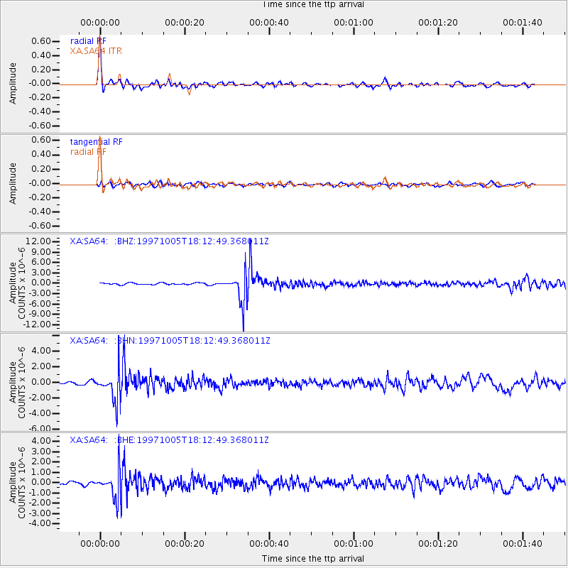
Signal To Noise
| Channel | StoN | STA | LTA |
| XA:SA64: :BHN:19971005T18:12:49.368011Z | 9.7745905 | 1.949055E-6 | 1.9940018E-7 |
| XA:SA64: :BHE:19971005T18:12:49.368011Z | 8.849194 | 1.3395462E-6 | 1.5137493E-7 |
| XA:SA64: :BHZ:19971005T18:12:49.368011Z | 16.512121 | 4.239605E-6 | 2.5675715E-7 |
| Arrivals |
| Ps | 4.7 SECOND |
| PpPs | 16 SECOND |
| PsPs/PpSs | 21 SECOND |


