
Station XA SA64 - XA.SA64
Network: XA97 - Anatomy of an Archean Craton, South Africa
Nearby stations (2 deg radius)
| Station | Name | (Lat, Lon) | Start / End | Elevation |
| SA64 | XA.SA64 | (-22.97, 26.20) | 1997-04-26 / 1999-12-31 | 1151 m |
| Crust2 Type: | G1,Archean, no seds. |
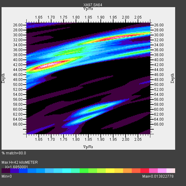
| Thickness Estimate: | 42 km |
| Thickness StdDev: | 8.4 km |
| Vp/Vs Estimate: | 1.69 |
| Vp/Vs StdDev: | 0.16 |
| Vs Estimate: | 3.834 km/s |
| Poisson's Ratio: | 0.23 |
| Peak Value: | 0.01 |
| Assumed Vp: | 6.459 km/s |
| Ps Weight: | 0.33333334 |
| PpPs Weight: | 0.33333334 |
| PsPs Weight: | 0.33333328 |
| Residual Complexity: | 0.721 |
| Nearby stations H: | +- |
| (2.0 deg) Vp/Vs: | +- |
5 with match > 90% ( 25.0 %) and 9 with match > 80% ( 45.0 %) out of 20.
Download stack as xyz text file.
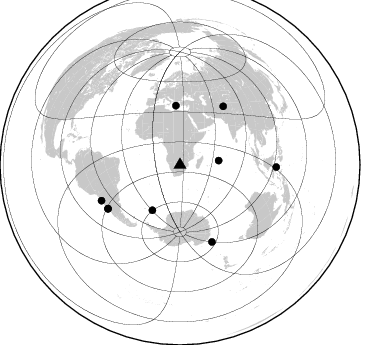
Azimuth Distribution of Events:
Prior Results for this Station
| Study | Thickness | Vp/Vs | Vp | Vs | Poissons Ratio | Extra |
| EARS | 42 km | 1.69 | 6.459 km/s | 3.834 km/s | 0.23 | |
| Crust2.0 | 37 km | 1.76 | 6.459 km/s | 3.665 km/s | 0.26 | G1,Archean, no seds. |
| Global Maxima | 42 km | 1.69 | 6.459 km/s | 3.834 km/s | 0.23 | amp=0.013822778 |
| Local Maxima 1 | 31 km | 1.98 | 6.459 km/s | 3.271 km/s | 0.33 | amp=0.012295045 |
| Local Maxima 2 | 60 km | 1.88 | 6.459 km/s | 3.431 km/s | 0.30 | amp=0.007586669 |
| Local Maxima 3 | 64 km | 1.84 | 6.459 km/s | 3.511 km/s | 0.29 | amp=0.00522863 |
| Local Maxima 4 | 36 km | 2.10 | 6.459 km/s | 3.08 km/s | 0.35 | amp=0.0048407237 |
| Predicted Arrivals for vertical incidence (zero ray parameter) | |
| Ps | 4.45 SECOND |
| PpPs | 17.46 SECOND |
| PsPs/PpSs | 21.91 SECOND |
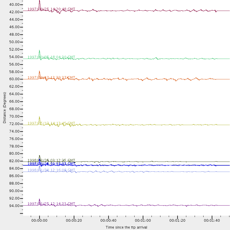
Events Processed for this Station
Download zip of receiver functions as SAC
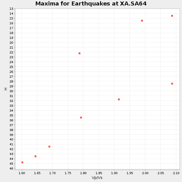
Plot maxima for each earthquake.
Events Used in the Stack
(9 events)| Radial Match | Distance | Baz | FERegion | Time | Lat/Lon | Depth | Magnitude |
| 98.949265 | 83.5 deg | 157.33 deg | Balleny Islands Region | 1998/03/25 03:12:25 GMT | (-62.9, 149.5) | 10 km | 6.6 MB, 8.0 MS, 8.3 UNKNOWN, 8.1 MW |
| 97.532196 | 84.5 deg | 238.876 deg | Near Coast Of Central Chile | 1997/10/15 01:03:33 GMT | (-30.9, -71.2) | 58 km | 6.8 MB, 6.8 MS, 7.3 UNKNOWN, 7.1 MW |
| 96.183975 | 86.4 deg | 245.674 deg | Near Coast Of Northern Chile | 1998/01/30 12:16:08 GMT | (-23.9, -70.2) | 42 km | 6.3 MB, 6.5 MS, 7.0 UNKNOWN, 6.7 ME |
| 94.202576 | 72.6 deg | 36.514 deg | Hindu Kush Region, Afghanistan | 1997/05/13 14:13:45 GMT | (36.4, 70.9) | 196 km | 6.1 MB, 6.5 UNKNOWN, 6.4 MW |
| 93.917465 | 84.6 deg | 238.764 deg | Near Coast Of Central Chile | 1998/01/12 10:14:07 GMT | (-31.0, -71.4) | 35 km | 5.8 MB, 6.2 MS, 6.6 UNKNOWN, 6.2 ME |
| 89.36628 | 96.3 deg | 91.324 deg | Minahassa Peninsula, Sulawesi | 1997/11/25 12:14:33 GMT | (1.2, 122.5) | 24 km | 6.1 MB, 6.8 MS, 7.1 UNKNOWN, 6.7 ME |
| 89.00746 | 53.2 deg | 211.395 deg | South Sandwich Islands Region | 1997/10/05 18:04:30 GMT | (-59.7, -29.2) | 274 km | 6.0 MB, 6.3 UNKNOWN, 6.3 MW |
| 84.9799 | 39.0 deg | 83.541 deg | Mid-Indian Ridge | 1997/09/25 14:20:48 GMT | (-13.8, 66.2) | 10 km | 5.3 MB, 5.7 MS, 6.0 UNKNOWN, 6.0 MW |
| 82.93408 | 59.2 deg | 356.118 deg | Southern Greece | 1997/10/13 13:39:37 GMT | (36.4, 22.1) | 24 km | 6.2 MB, 6.6 MS, 6.7 UNKNOWN, 6.5 MW |
Losers
(11 events)| Radial Match | Distance | Baz | FERegion | Time | Lat/Lon | Depth | Magnitude | Reason |
| 79.50872 | 38.8 deg | 241.517 deg | Southern Mid-Atlantic Ridge | 1998/01/03 06:10:08 GMT | (-35.5, -16.2) | 10 km | 5.9 MS, 5.4 MB, 6.3 UNKNOWN, 6.1 MW | |
| 73.20824 | 85.3 deg | 239.454 deg | Near Coast Of Central Chile | 1997/07/06 09:54:00 GMT | (-30.1, -71.9) | 19 km | 5.8 MB, 6.5 MS, 6.8 UNKNOWN, 6.4 ME | |
| 71.06202 | 84.6 deg | 242.942 deg | Northern Chile | 1997/05/17 02:10:18 GMT | (-27.2, -69.5) | 106 km | 5.5 MB, 5.6 UNKNOWN, 5.5 MW | |
| 70.87672 | 78.6 deg | 320.227 deg | Azores Islands, Portugal | 1997/06/27 04:39:52 GMT | (38.3, -26.7) | 10 km | 5.6 MB, 5.4 MS, 5.9 UNKNOWN, 5.9 MW | |
| 69.64911 | 83.5 deg | 247.923 deg | Jujuy Province, Argentina | 1997/07/20 10:14:22 GMT | (-23.0, -66.3) | 256 km | 5.7 MB, 6.1 UNKNOWN, 5.7 ME | |
| 67.326256 | 85.5 deg | 240.231 deg | Near Coast Of Central Chile | 1997/07/19 12:22:57 GMT | (-29.3, -71.7) | 26 km | 5.8 MB, 5.5 MS, 5.9 UNKNOWN, 5.8 MW | |
| 63.950676 | 85.5 deg | 247.693 deg | Northern Chile | 1997/09/28 23:13:13 GMT | (-22.4, -68.4) | 107 km | 5.7 MB, 5.6 UNKNOWN, 5.6 MW | |
| 62.36994 | 86.3 deg | 249.718 deg | Chile-Bolivia Border Region | 1997/12/09 14:23:45 GMT | (-20.2, -68.4) | 133 km | 5.7 MB, 5.7 UNKNOWN, 5.7 MW | |
| 61.95118 | 83.4 deg | 59.07 deg | Myanmar | 1997/12/30 13:43:18 GMT | (25.4, 96.6) | 33 km | 5.7 MS, 5.4 MB, 5.7 UNKNOWN, 5.7 MW | |
| 56.273663 | 89.2 deg | 255.502 deg | Peru-Bolivia Border Region | 1997/11/28 22:53:41 GMT | (-13.7, -68.8) | 586 km | 6.4 MB, 6.6 UNKNOWN, 6.6 MW | |
| 35.56787 | 82.8 deg | 93.149 deg | Java Sea | 1997/07/11 09:55:12 GMT | (-5.7, 110.8) | 574 km | 5.6 MB |
