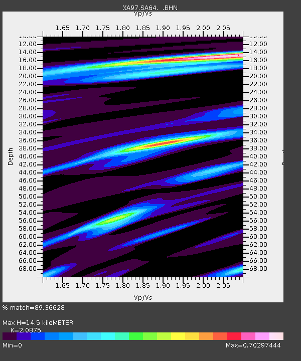
SA64 XA.SA64 - Earthquake Result Viewer

Earthquake location: Minahassa Peninsula, Sulawesi
Earthquake latitude/longitude: 1.2/122.5
Earthquake time(UTC): 1997/11/25 (329) 12:14:33 GMT
Earthquake Depth: 24 km
Earthquake Magnitude: 6.1 MB, 6.8 MS, 7.1 UNKNOWN, 6.7 ME
Earthquake Catalog/Contributor: WHDF/NEIC
Network: XA Anatomy of an Archean Craton, South Africa
Station: SA64 XA.SA64
Lat/Lon: 22.97 S/26.20 E
Elevation: 1151 m
Distance: 96.3 deg
Az: 247.164 deg
Baz: 91.324 deg
Ray Param: 0.04054078
Estimated Moho Depth: 14.5 km
Estimated Crust Vp/Vs: 2.09
Assumed Crust Vp: 6.459 km/s
Estimated Crust Vs: 3.094 km/s
Estimated Crust Poisson's Ratio: 0.35
Radial Match: 89.36628 %
Radial Bump: 270
Transverse Match: 64.72211 %
Transverse Bump: 400
SOD ConfigId: 4480
Insert Time: 2010-02-26 18:26:55.368 +0000
GWidth: 2.5
Max Bumps: 400
Tol: 0.001

Signal To Noise

ChannelStoNSTALTA
XA:SA64: :BHN:19971125T12:27:28.417993Z10.6053682.0644277E-61.9465875E-7
XA:SA64: :BHE:19971125T12:27:28.417993Z0.55504676.5173474E-81.1741981E-7
XA:SA64: :BHZ:19971125T12:27:28.417993Z4.81723647.652773E-71.588623E-7
Arrivals
Ps2.5 SECOND
PpPs6.8 SECOND
PsPs/PpSs9.3 SECOND