You are here: Home > Network List > TA - USArray Transportable Network (new EarthScope stations) Stations List
> Station W37A Quinton, OK, USA > Earthquake Result Viewer
W37A Quinton, OK, USA - Earthquake Result Viewer
| Earthquake location: |
Near Coast Of Central Chile |
| Earthquake latitude/longitude: |
-38.1/-73.3 |
| Earthquake time(UTC): |
2010/07/14 (195) 08:32:21 GMT |
| Earthquake Depth: |
22 km |
| Earthquake Magnitude: |
5.9 MB, 6.5 MS, 6.6 MW, 6.5 MW |
| Earthquake Catalog/Contributor: |
WHDF/NEIC |
|
| Network: |
TA USArray Transportable Network (new EarthScope stations) |
| Station: |
W37A Quinton, OK, USA |
| Lat/Lon: |
35.14 N/95.43 W |
| Elevation: |
281 m |
|
| Distance: |
75.7 deg |
| Az: |
341.429 deg |
| Baz: |
162.139 deg |
| Ray Param: |
0.051488005 |
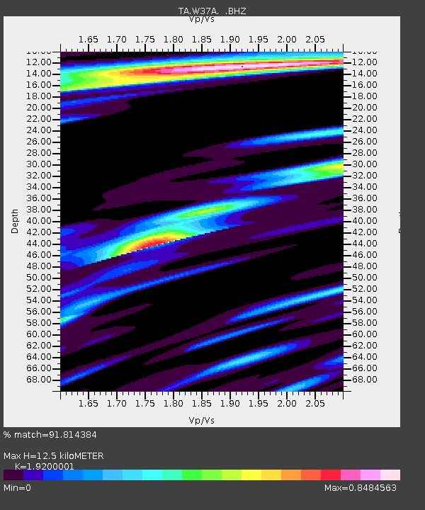
| Estimated Moho Depth: |
12.5 km |
| Estimated Crust Vp/Vs: |
1.92 |
| Assumed Crust Vp: |
6.498 km/s |
| Estimated Crust Vs: |
3.384 km/s |
| Estimated Crust Poisson's Ratio: |
0.31 |
|
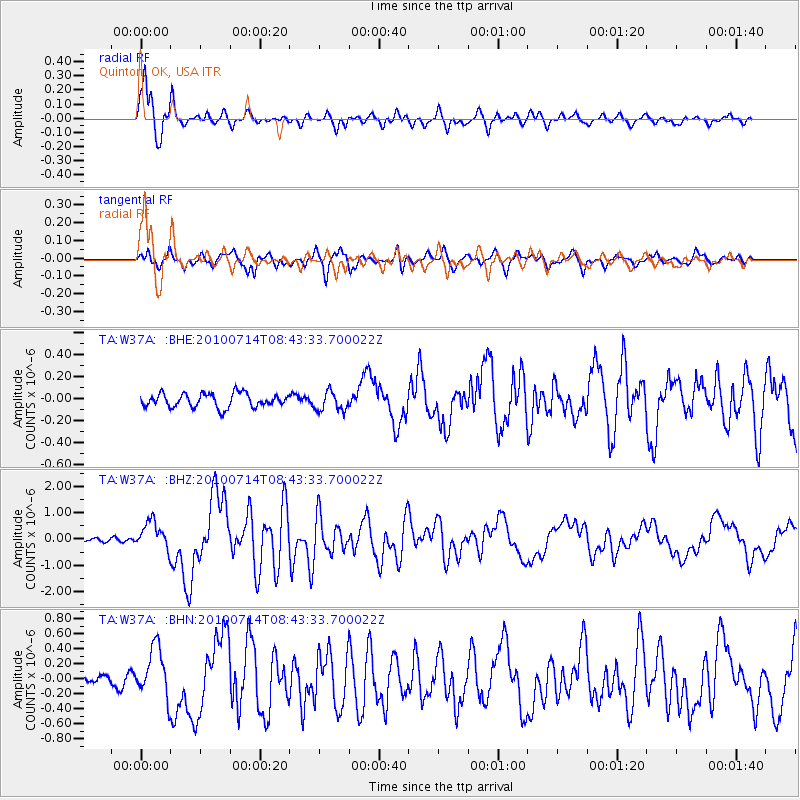
| Radial Match: |
91.814384 % |
| Radial Bump: |
328 |
| Transverse Match: |
80.0094 % |
| Transverse Bump: |
400 |
| SOD ConfigId: |
319893 |
| Insert Time: |
2011-01-05 03:28:35.202 +0000 |
| GWidth: |
2.5 |
| Max Bumps: |
400 |
| Tol: |
0.001 |
|
Signal To Noise
| Channel | StoN | STA | LTA |
| TA:W37A: :BHZ:20100714T08:43:33.700022Z | 4.6273146 | 5.2394466E-7 | 1.1322867E-7 |
| TA:W37A: :BHN:20100714T08:43:33.700022Z | 3.707248 | 3.3532552E-7 | 9.045134E-8 |
| TA:W37A: :BHE:20100714T08:43:33.700022Z | 1.4095879 | 8.902137E-8 | 6.315418E-8 |
| Arrivals |
| Ps | 1.8 SECOND |
| PpPs | 5.5 SECOND |
| PsPs/PpSs | 7.3 SECOND |


