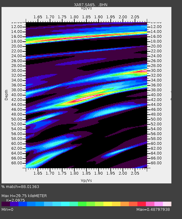
SA65 XA.SA65 - Earthquake Result Viewer
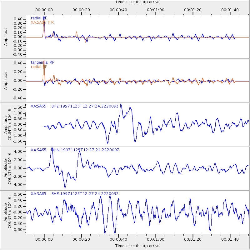
Earthquake location: Minahassa Peninsula, Sulawesi
Earthquake latitude/longitude: 1.2/122.5
Earthquake time(UTC): 1997/11/25 (329) 12:14:33 GMT
Earthquake Depth: 24 km
Earthquake Magnitude: 6.1 MB, 6.8 MS, 7.1 UNKNOWN, 6.7 ME
Earthquake Catalog/Contributor: WHDF/NEIC
Network: XA Anatomy of an Archean Craton, South Africa
Station: SA65 XA.SA65
Lat/Lon: 22.82 S/27.22 E
Elevation: 907 m
Distance: 95.4 deg
Az: 247.333 deg
Baz: 90.913 deg
Ray Param: 0.040789705
Estimated Moho Depth: 29.75 km
Estimated Crust Vp/Vs: 2.10
Assumed Crust Vp: 6.459 km/s
Estimated Crust Vs: 3.08 km/s
Estimated Crust Poisson's Ratio: 0.35
Radial Match: 88.01363 %
Radial Bump: 362
Transverse Match: 77.70477 %
Transverse Bump: 400
SOD ConfigId: 4480
Insert Time: 2010-02-26 18:27:21.260 +0000
GWidth: 2.5
Max Bumps: 400
Tol: 0.001

Signal To Noise

ChannelStoNSTALTA
XA:SA65: :BHN:19971125T12:27:24.222009Z8.2595612.252784E-62.7274868E-7
XA:SA65: :BHE:19971125T12:27:24.222009Z1.14443271.857677E-71.6232296E-7
XA:SA65: :BHZ:19971125T12:27:24.222009Z3.46681647.157009E-72.0644326E-7
Arrivals
Ps5.1 SECOND
PpPs14 SECOND
PsPs/PpSs19 SECOND