
Station XA SA65 - XA.SA65
Network: XA97 - Anatomy of an Archean Craton, South Africa
Nearby stations (2 deg radius)
| Station | Name | (Lat, Lon) | Start / End | Elevation |
| SA65 | XA.SA65 | (-22.82, 27.22) | 1997-05-01 / 1999-12-31 | 907 m |
| Crust2 Type: | G1,Archean, no seds. |
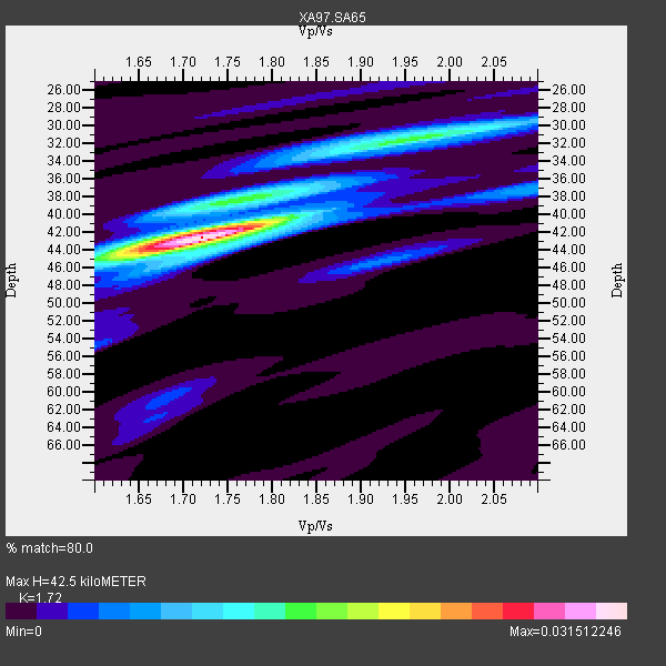
| Thickness Estimate: | 42 km |
| Thickness StdDev: | 0.4 km |
| Vp/Vs Estimate: | 1.72 |
| Vp/Vs StdDev: | 0.03 |
| Vs Estimate: | 3.755 km/s |
| Poisson's Ratio: | 0.24 |
| Peak Value: | 0.03 |
| Assumed Vp: | 6.459 km/s |
| Ps Weight: | 0.33333334 |
| PpPs Weight: | 0.33333334 |
| PsPs Weight: | 0.33333328 |
| Residual Complexity: | 0.482 |
| Nearby stations H: | +- |
| (2.0 deg) Vp/Vs: | +- |
5 with match > 90% ( 21.73913 %) and 8 with match > 80% ( 34.782608 %) out of 23.
Download stack as xyz text file.
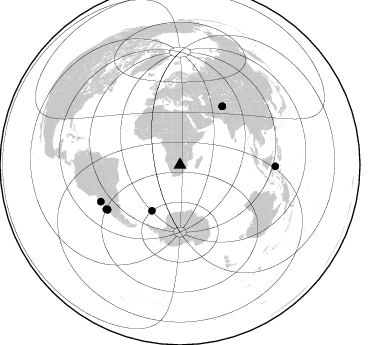
Azimuth Distribution of Events:
Prior Results for this Station
| Study | Thickness | Vp/Vs | Vp | Vs | Poissons Ratio | Extra |
| EARS | 42 km | 1.72 | 6.459 km/s | 3.755 km/s | 0.24 | |
| Crust2.0 | 37 km | 1.76 | 6.459 km/s | 3.665 km/s | 0.26 | G1,Archean, no seds. |
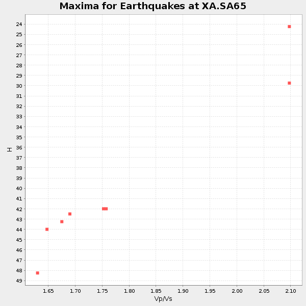
| Global Maxima | 42 km | 1.72 | 6.459 km/s | 3.755 km/s | 0.24 | amp=0.031512246 |
| Local Maxima 1 | 32 km | 1.95 | 6.459 km/s | 3.308 km/s | 0.32 | amp=0.013975421 |
| Local Maxima 2 | 39 km | 1.72 | 6.459 km/s | 3.761 km/s | 0.24 | amp=0.0103567885 |
| Local Maxima 3 | 45 km | 1.92 | 6.459 km/s | 3.364 km/s | 0.31 | amp=0.005859702 |
| Local Maxima 4 | 41 km | 1.74 | 6.459 km/s | 3.707 km/s | 0.25 | amp=0.0054410677 |
| Predicted Arrivals for vertical incidence (zero ray parameter) | |
| Ps | 4.74 SECOND |
| PpPs | 17.90 SECOND |
| PsPs/PpSs | 22.63 SECOND |
Events Processed for this Station
Download zip of receiver functions as SAC
Plot maxima for each earthquake.
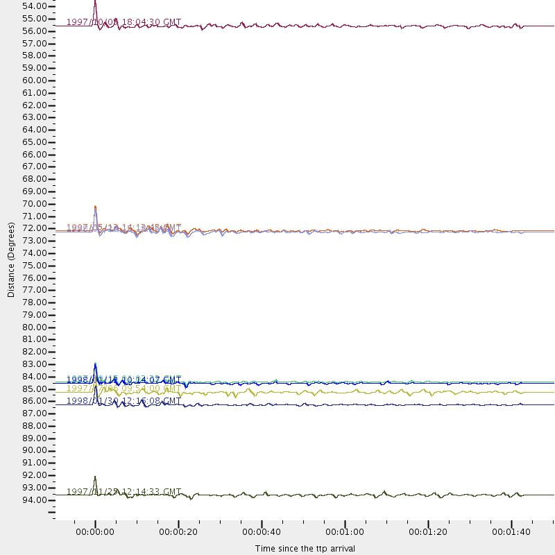
Events Used in the Stack
(8 events)| Radial Match | Distance | Baz | FERegion | Time | Lat/Lon | Depth | Magnitude |
| 98.759315 | 85.4 deg | 238.514 deg | Near Coast Of Central Chile | 1997/10/15 01:03:33 GMT | (-30.9, -71.2) | 58 km | 6.8 MB, 6.8 MS, 7.3 UNKNOWN, 7.1 MW |
| 97.46631 | 87.3 deg | 245.293 deg | Near Coast Of Northern Chile | 1998/01/30 12:16:08 GMT | (-23.9, -70.2) | 42 km | 6.3 MB, 6.5 MS, 7.0 UNKNOWN, 6.7 ME |
| 96.71445 | 71.9 deg | 35.905 deg | Hindu Kush Region, Afghanistan | 1997/05/13 14:13:45 GMT | (36.4, 70.9) | 196 km | 6.1 MB, 6.5 UNKNOWN, 6.4 MW |
| 95.503105 | 85.5 deg | 238.4 deg | Near Coast Of Central Chile | 1998/01/12 10:14:07 GMT | (-31.0, -71.4) | 35 km | 5.8 MB, 6.2 MS, 6.6 UNKNOWN, 6.2 ME |
| 90.65163 | 72.1 deg | 35.946 deg | Afghanistan-Tajikistan Bord Reg. | 1998/02/20 12:18:06 GMT | (36.5, 71.1) | 236 km | 5.8 MB, 5.7 MS, 6.4 UNKNOWN, 6.3 MW |
| 88.01363 | 95.4 deg | 90.913 deg | Minahassa Peninsula, Sulawesi | 1997/11/25 12:14:33 GMT | (1.2, 122.5) | 24 km | 6.1 MB, 6.8 MS, 7.1 UNKNOWN, 6.7 ME |
| 83.7497 | 53.8 deg | 211.537 deg | South Sandwich Islands Region | 1997/10/05 18:04:30 GMT | (-59.7, -29.2) | 274 km | 6.0 MB, 6.3 UNKNOWN, 6.3 MW |
| 82.45676 | 86.2 deg | 239.085 deg | Near Coast Of Central Chile | 1997/07/06 09:54:00 GMT | (-30.1, -71.9) | 19 km | 5.8 MB, 6.5 MS, 6.8 UNKNOWN, 6.4 ME |
Losers
(15 events)| Radial Match | Distance | Baz | FERegion | Time | Lat/Lon | Depth | Magnitude | Reason |
| 78.414764 | 39.7 deg | 241.51 deg | Southern Mid-Atlantic Ridge | 1998/01/03 06:10:08 GMT | (-35.5, -16.2) | 10 km | 5.9 MS, 5.4 MB, 6.3 UNKNOWN, 6.1 MW | |
| 74.99354 | 72.4 deg | 81.151 deg | Northern Sumatra, Indonesia | 1997/07/07 11:24:37 GMT | (1.1, 97.6) | 29 km | 5.7 MS, 5.4 MB, 5.9 UNKNOWN, 5.8 MW | |
| 73.60677 | 60.4 deg | 354.001 deg | Ionian Sea | 1997/11/18 13:07:41 GMT | (37.6, 20.7) | 33 km | 5.9 MB, 6.4 MS, 6.7 UNKNOWN, 6.1 ML | |
| 72.27472 | 86.4 deg | 239.86 deg | Near Coast Of Central Chile | 1997/07/19 12:22:57 GMT | (-29.3, -71.7) | 26 km | 5.8 MB, 5.5 MS, 5.9 UNKNOWN, 5.8 MW | |
| 69.53042 | 77.9 deg | 59.578 deg | India-Bangladesh Border Region | 1997/11/21 11:23:06 GMT | (22.2, 92.7) | 54 km | 5.9 MB, 6.1 UNKNOWN, 6.1 MW | |
| 66.32295 | 84.4 deg | 247.552 deg | Jujuy Province, Argentina | 1997/07/20 10:14:22 GMT | (-23.0, -66.3) | 256 km | 5.7 MB, 6.1 UNKNOWN, 5.7 ME | |
| 65.923935 | 81.9 deg | 92.781 deg | Java Sea | 1997/07/11 09:55:12 GMT | (-5.7, 110.8) | 574 km | 5.6 MB | |
| 64.023445 | 47.8 deg | 126.229 deg | Mid-Indian Ridge | 1997/08/20 13:51:16 GMT | (-41.7, 80.1) | 10 km | 5.6 MB, 6.4 MS, 6.5 UNKNOWN, 6.4 MW | |
| 59.237247 | 87.8 deg | 161.411 deg | Balleny Islands Region | 1997/12/16 07:06:56 GMT | (-62.9, 163.2) | 10 km | 5.6 MS, 4.7 MB | |
| 58.74097 | 79.1 deg | 319.671 deg | Azores Islands, Portugal | 1997/06/27 04:39:52 GMT | (38.3, -26.7) | 10 km | 5.6 MB, 5.4 MS, 5.9 UNKNOWN, 5.9 MW | |
| 58.54365 | 90.2 deg | 255.108 deg | Peru-Bolivia Border Region | 1997/11/28 22:53:41 GMT | (-13.7, -68.8) | 586 km | 6.4 MB, 6.6 UNKNOWN, 6.6 MW | |
| 57.83942 | 86.1 deg | 238.704 deg | Near Coast Of Central Chile | 1997/07/25 06:47:02 GMT | (-30.5, -71.9) | 33 km | 5.6 MB, 5.5 MS, 6.3 UNKNOWN | |
| 56.386127 | 87.2 deg | 249.334 deg | Chile-Bolivia Border Region | 1997/12/09 14:23:45 GMT | (-20.2, -68.4) | 133 km | 5.7 MB, 5.7 UNKNOWN, 5.7 MW | |
| 51.673622 | 85.5 deg | 242.574 deg | Northern Chile | 1997/05/17 02:10:18 GMT | (-27.2, -69.5) | 106 km | 5.5 MB, 5.6 UNKNOWN, 5.5 MW | |
| 38.53511 | 38.0 deg | 83.198 deg | Mid-Indian Ridge | 1997/09/25 14:20:48 GMT | (-13.8, 66.2) | 10 km | 5.3 MB, 5.7 MS, 6.0 UNKNOWN, 6.0 MW |
