You are here: Home > Network List > XA97 - Anatomy of an Archean Craton, South Africa Stations List
> Station SA67 XA.SA67 > Earthquake Result Viewer
SA67 XA.SA67 - Earthquake Result Viewer
| Earthquake location: |
South Sandwich Islands Region |
| Earthquake latitude/longitude: |
-59.7/-29.2 |
| Earthquake time(UTC): |
1997/10/05 (278) 18:04:30 GMT |
| Earthquake Depth: |
274 km |
| Earthquake Magnitude: |
6.0 MB, 6.3 UNKNOWN, 6.3 MW |
| Earthquake Catalog/Contributor: |
WHDF/NEIC |
|
| Network: |
XA Anatomy of an Archean Craton, South Africa |
| Station: |
SA67 XA.SA67 |
| Lat/Lon: |
21.89 S/27.27 E |
| Elevation: |
913 m |
|
| Distance: |
54.6 deg |
| Az: |
71.794 deg |
| Baz: |
211.198 deg |
| Ray Param: |
0.06435613 |
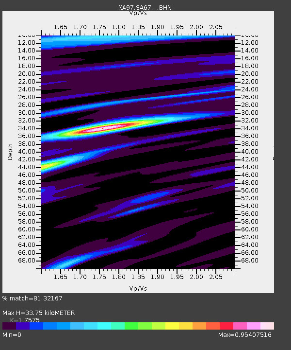
| Estimated Moho Depth: |
33.75 km |
| Estimated Crust Vp/Vs: |
1.76 |
| Assumed Crust Vp: |
6.459 km/s |
| Estimated Crust Vs: |
3.675 km/s |
| Estimated Crust Poisson's Ratio: |
0.26 |
|
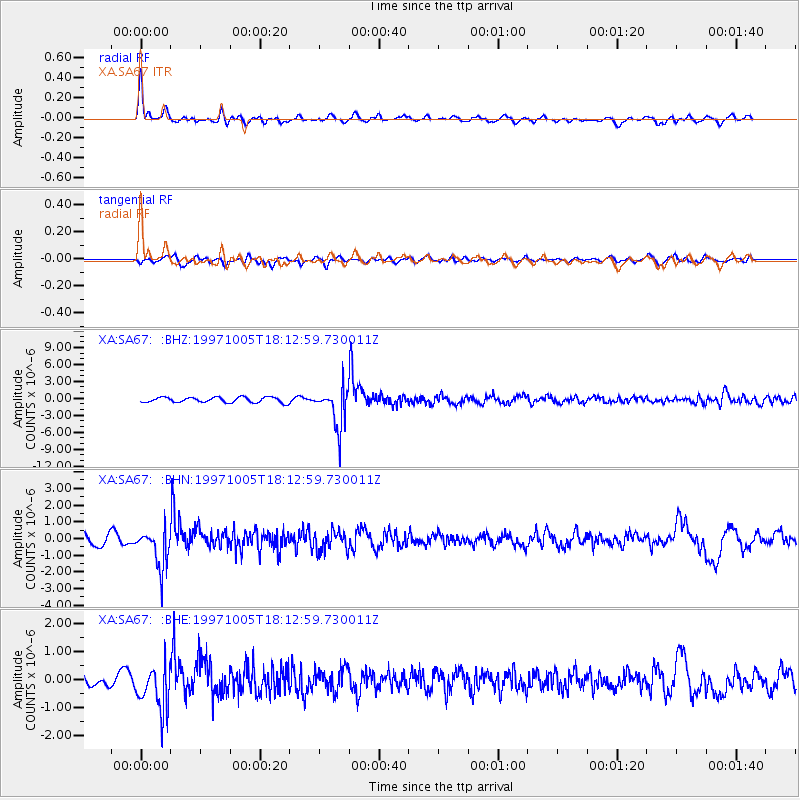
| Radial Match: |
81.32167 % |
| Radial Bump: |
398 |
| Transverse Match: |
67.88648 % |
| Transverse Bump: |
400 |
| SOD ConfigId: |
6273 |
| Insert Time: |
2010-02-26 18:28:15.333 +0000 |
| GWidth: |
2.5 |
| Max Bumps: |
400 |
| Tol: |
0.001 |
|
Signal To Noise
| Channel | StoN | STA | LTA |
| XA:SA67: :BHN:19971005T18:12:59.730011Z | 4.0978494 | 1.2039151E-6 | 2.9379194E-7 |
| XA:SA67: :BHE:19971005T18:12:59.730011Z | 3.4725747 | 8.197298E-7 | 2.3605821E-7 |
| XA:SA67: :BHZ:19971005T18:12:59.730011Z | 7.8102846 | 3.6201202E-6 | 4.635068E-7 |
| Arrivals |
| Ps | 4.2 SECOND |
| PpPs | 14 SECOND |
| PsPs/PpSs | 18 SECOND |


