
Station XA SA67 - XA.SA67
Network: XA97 - Anatomy of an Archean Craton, South Africa
Nearby stations (2 deg radius)
| Station | Name | (Lat, Lon) | Start / End | Elevation |
| SA67 | XA.SA67 | (-21.89, 27.27) | 1997-04-30 / 1999-12-31 | 913 m |
| Crust2 Type: | G1,Archean, no seds. |
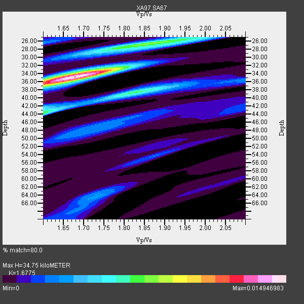
| Thickness Estimate: | 35 km |
| Thickness StdDev: | 3.1 km |
| Vp/Vs Estimate: | 1.68 |
| Vp/Vs StdDev: | 0.08 |
| Vs Estimate: | 3.851 km/s |
| Poisson's Ratio: | 0.22 |
| Peak Value: | 0.01 |
| Assumed Vp: | 6.459 km/s |
| Ps Weight: | 0.33333334 |
| PpPs Weight: | 0.33333334 |
| PsPs Weight: | 0.33333328 |
| Residual Complexity: | 0.648 |
| Nearby stations H: | +- |
| (2.0 deg) Vp/Vs: | +- |
8 with match > 90% ( 30.76923 %) and 13 with match > 80% ( 50.0 %) out of 26.
Download stack as xyz text file.
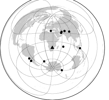
Azimuth Distribution of Events:
Prior Results for this Station
| Study | Thickness | Vp/Vs | Vp | Vs | Poissons Ratio | Extra |
| EARS | 35 km | 1.68 | 6.459 km/s | 3.851 km/s | 0.22 | |
| Crust2.0 | 37 km | 1.76 | 6.459 km/s | 3.665 km/s | 0.26 | G1,Archean, no seds. |
| Global Maxima | 35 km | 1.68 | 6.459 km/s | 3.851 km/s | 0.22 | amp=0.014946983 |
| Local Maxima 1 | 26 km | 1.86 | 6.459 km/s | 3.468 km/s | 0.30 | amp=0.0073859063 |
| Local Maxima 2 | 44 km | 1.60 | 6.459 km/s | 4.037 km/s | 0.18 | amp=0.007079103 |
| Local Maxima 3 | 38 km | 1.83 | 6.459 km/s | 3.535 km/s | 0.29 | amp=0.0065313648 |
| Local Maxima 4 | 33 km | 1.74 | 6.459 km/s | 3.723 km/s | 0.25 | amp=0.004133519 |
| Predicted Arrivals for vertical incidence (zero ray parameter) | |
| Ps | 3.64 SECOND |
| PpPs | 14.40 SECOND |
| PsPs/PpSs | 18.05 SECOND |
Events Processed for this Station
Download zip of receiver functions as SAC
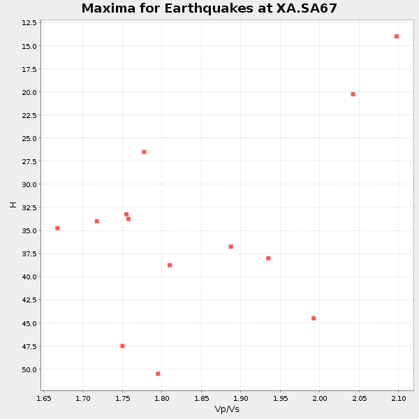
Plot maxima for each earthquake.
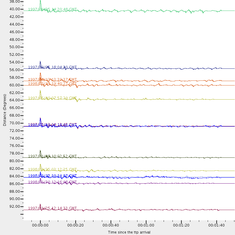
Events Used in the Stack
(13 events)| Radial Match | Distance | Baz | FERegion | Time | Lat/Lon | Depth | Magnitude |
| 98.56577 | 84.1 deg | 157.067 deg | Balleny Islands Region | 1998/03/25 03:12:25 GMT | (-62.9, 149.5) | 10 km | 6.6 MB, 8.0 MS, 8.3 UNKNOWN, 8.1 MW |
| 98.3027 | 85.9 deg | 238.436 deg | Near Coast Of Central Chile | 1997/10/15 01:03:33 GMT | (-30.9, -71.2) | 58 km | 6.8 MB, 6.8 MS, 7.3 UNKNOWN, 7.1 MW |
| 96.894455 | 63.5 deg | 30.024 deg | Northern And Central Iran | 1997/05/10 07:57:29 GMT | (33.8, 59.8) | 10 km | 6.4 MB, 7.3 MS, 7.5 UNKNOWN, 7.2 MW |
| 96.163445 | 87.8 deg | 245.238 deg | Near Coast Of Northern Chile | 1998/01/30 12:16:08 GMT | (-23.9, -70.2) | 42 km | 6.3 MB, 6.5 MS, 7.0 UNKNOWN, 6.7 ME |
| 95.48363 | 80.3 deg | 46.14 deg | Xizang | 1997/11/08 10:02:52 GMT | (35.1, 87.3) | 33 km | 6.2 MB, 7.9 MS, 7.7 UNKNOWN, 7.6 MW |
| 94.46886 | 71.2 deg | 36.055 deg | Hindu Kush Region, Afghanistan | 1997/05/13 14:13:45 GMT | (36.4, 70.9) | 196 km | 6.1 MB, 6.5 UNKNOWN, 6.4 MW |
| 91.69737 | 86.0 deg | 238.324 deg | Near Coast Of Central Chile | 1998/01/12 10:14:07 GMT | (-31.0, -71.4) | 35 km | 5.8 MB, 6.2 MS, 6.6 UNKNOWN, 6.2 ME |
| 90.78282 | 59.4 deg | 30.543 deg | Northern And Central Iran | 1998/03/14 19:40:27 GMT | (30.2, 57.6) | 9.0 km | 5.9 MB, 6.9 MS, 6.6 UNKNOWN, 6.3 ME |
| 88.752205 | 95.3 deg | 90.806 deg | Minahassa Peninsula, Sulawesi | 1997/11/25 12:14:33 GMT | (1.2, 122.5) | 24 km | 6.1 MB, 6.8 MS, 7.1 UNKNOWN, 6.7 ME |
| 86.27241 | 58.2 deg | 355.058 deg | Southern Greece | 1997/10/13 13:39:37 GMT | (36.4, 22.1) | 24 km | 6.2 MB, 6.6 MS, 6.7 UNKNOWN, 6.5 MW |
| 85.48851 | 71.3 deg | 36.094 deg | Afghanistan-Tajikistan Bord Reg. | 1998/02/20 12:18:06 GMT | (36.5, 71.1) | 236 km | 5.8 MB, 5.7 MS, 6.4 UNKNOWN, 6.3 MW |
| 82.58243 | 37.9 deg | 84.354 deg | Mid-Indian Ridge | 1997/09/25 14:20:48 GMT | (-13.8, 66.2) | 10 km | 5.3 MB, 5.7 MS, 6.0 UNKNOWN, 6.0 MW |
| 81.32167 | 54.6 deg | 211.198 deg | South Sandwich Islands Region | 1997/10/05 18:04:30 GMT | (-59.7, -29.2) | 274 km | 6.0 MB, 6.3 UNKNOWN, 6.3 MW |
Losers
(13 events)| Radial Match | Distance | Baz | FERegion | Time | Lat/Lon | Depth | Magnitude | Reason |
| 85.9055 | 71.0 deg | 35.964 deg | Hindu Kush Region, Afghanistan | 1997/12/17 05:51:29 GMT | (36.4, 70.8) | 207 km | 5.5 MB, 6.3 UNKNOWN | |
| 77.22545 | 78.4 deg | 319.525 deg | Azores Islands, Portugal | 1997/06/27 04:39:52 GMT | (38.3, -26.7) | 10 km | 5.6 MB, 5.4 MS, 5.9 UNKNOWN, 5.9 MW | |
| 71.60605 | 90.4 deg | 255.093 deg | Peru-Bolivia Border Region | 1997/11/28 22:53:41 GMT | (-13.7, -68.8) | 586 km | 6.4 MB, 6.6 UNKNOWN, 6.6 MW | |
| 65.63492 | 85.9 deg | 242.494 deg | Northern Chile | 1997/05/17 02:10:18 GMT | (-27.2, -69.5) | 106 km | 5.5 MB, 5.6 UNKNOWN, 5.5 MW | |
| 63.8554 | 40.2 deg | 240.548 deg | Southern Mid-Atlantic Ridge | 1998/01/03 06:10:08 GMT | (-35.5, -16.2) | 10 km | 5.9 MS, 5.4 MB, 6.3 UNKNOWN, 6.1 MW | |
| 62.187134 | 84.8 deg | 247.453 deg | Jujuy Province, Argentina | 1997/07/20 10:14:22 GMT | (-23.0, -66.3) | 256 km | 5.7 MB, 6.1 UNKNOWN, 5.7 ME | |
| 60.50624 | 72.5 deg | 77.821 deg | Northern Sumatra, Indonesia | 1997/08/20 07:15:15 GMT | (4.4, 96.5) | 33 km | 5.9 MB, 6.0 MS, 6.1 UNKNOWN, 6.0 MW | |
| 59.47038 | 86.6 deg | 238.636 deg | Near Coast Of Central Chile | 1997/07/25 06:47:02 GMT | (-30.5, -71.9) | 33 km | 5.6 MB, 5.5 MS, 6.3 UNKNOWN | |
| 56.265247 | 86.9 deg | 239.795 deg | Near Coast Of Central Chile | 1997/07/19 12:22:57 GMT | (-29.3, -71.7) | 26 km | 5.8 MB, 5.5 MS, 5.9 UNKNOWN, 5.8 MW | |
| 50.506016 | 86.9 deg | 247.245 deg | Northern Chile | 1997/09/28 23:13:13 GMT | (-22.4, -68.4) | 107 km | 5.7 MB, 5.6 UNKNOWN, 5.6 MW | |
| 49.581844 | 81.9 deg | 92.894 deg | Java Sea | 1997/07/11 09:55:12 GMT | (-5.7, 110.8) | 574 km | 5.6 MB | |
| 47.211353 | 87.6 deg | 249.276 deg | Chile-Bolivia Border Region | 1997/12/09 14:23:45 GMT | (-20.2, -68.4) | 133 km | 5.7 MB, 5.7 UNKNOWN, 5.7 MW | |
| 41.94002 | 82.0 deg | 58.716 deg | Myanmar | 1997/12/30 13:43:18 GMT | (25.4, 96.6) | 33 km | 5.7 MS, 5.4 MB, 5.7 UNKNOWN, 5.7 MW |
