You are here: Home > Network List > SP - South Carolina Earth Physics Project Stations List
> Station AGBLF Silver Bluff High School, Aiken County, SC, USA > Earthquake Result Viewer
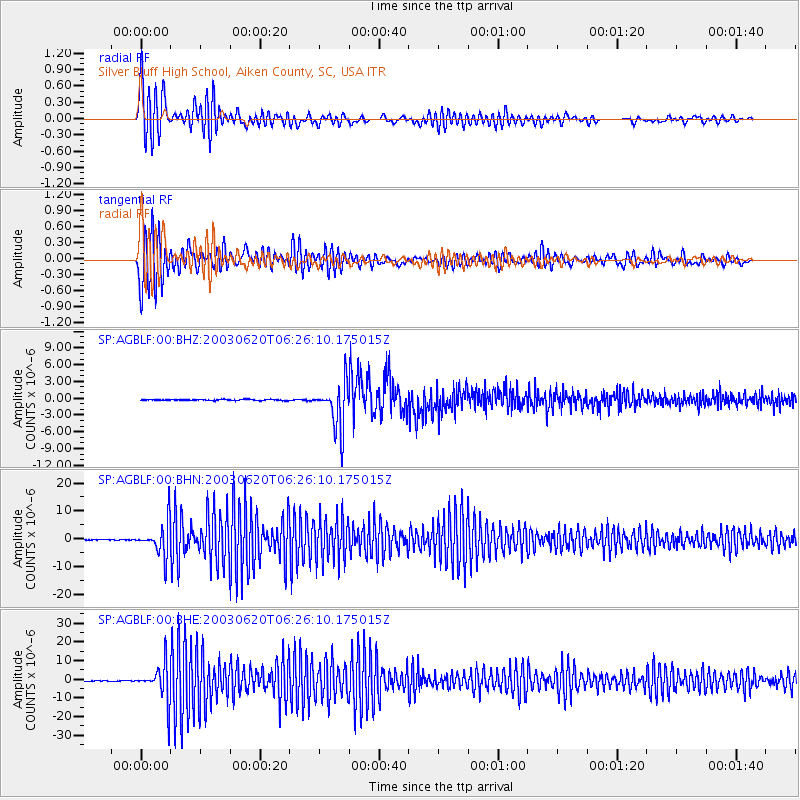
AGBLF Silver Bluff High School, Aiken County, SC, USA - Earthquake Result Viewer
*The percent match for this event was below the threshold and hence no stack was calculated.
| Earthquake location: |
Western Brazil |
| Earthquake latitude/longitude: |
-7.6/-71.7 |
| Earthquake time(UTC): |
2003/06/20 (171) 06:19:38 GMT |
| Earthquake Depth: |
558 km |
| Earthquake Magnitude: |
6.4 MB, 7.1 MW, 7.0 MW |
| Earthquake Catalog/Contributor: |
WHDF/NEIC |
|
| Network: |
SP South Carolina Earth Physics Project |
| Station: |
AGBLF Silver Bluff High School, Aiken County, SC, USA |
| Lat/Lon: |
33.40 N/81.76 W |
| Elevation: |
118 m |
|
| Distance: |
41.9 deg |
| Az: |
347.384 deg |
| Baz: |
165.001 deg |
| Ray Param: |
$rayparam |
*The percent match for this event was below the threshold and hence was not used in the summary stack. |
|
| Radial Match: |
86.024155 % |
| Radial Bump: |
400 |
| Transverse Match: |
81.435646 % |
| Transverse Bump: |
400 |
| SOD ConfigId: |
2277 |
| Insert Time: |
2010-02-25 19:31:38.821 +0000 |
| GWidth: |
2.5 |
| Max Bumps: |
400 |
| Tol: |
0.001 |
|
Signal To Noise
| Channel | StoN | STA | LTA |
| SP:AGBLF:00:BHN:20030620T06:26:10.175015Z | 46.2924 | 5.959066E-6 | 1.2872665E-7 |
| SP:AGBLF:00:BHE:20030620T06:26:10.175015Z | 49.806305 | 9.705557E-6 | 1.9486605E-7 |
| SP:AGBLF:00:BHZ:20030620T06:26:10.175015Z | 43.94439 | 4.190265E-6 | 9.5353805E-8 |
| Arrivals |
| Ps | |
| PpPs | |
| PsPs/PpSs | |


