You are here: Home > Network List > XA97 - Anatomy of an Archean Craton, South Africa Stations List
> Station SA70 XA.SA70 > Earthquake Result Viewer
SA70 XA.SA70 - Earthquake Result Viewer
| Earthquake location: |
Southern Greece |
| Earthquake latitude/longitude: |
36.4/22.1 |
| Earthquake time(UTC): |
1997/10/13 (286) 13:39:37 GMT |
| Earthquake Depth: |
24 km |
| Earthquake Magnitude: |
6.2 MB, 6.6 MS, 6.7 UNKNOWN, 6.5 MW |
| Earthquake Catalog/Contributor: |
WHDF/NEIC |
|
| Network: |
XA Anatomy of an Archean Craton, South Africa |
| Station: |
SA70 XA.SA70 |
| Lat/Lon: |
21.09 S/26.34 E |
| Elevation: |
990 m |
|
| Distance: |
57.3 deg |
| Az: |
175.267 deg |
| Baz: |
355.911 deg |
| Ray Param: |
0.06354727 |
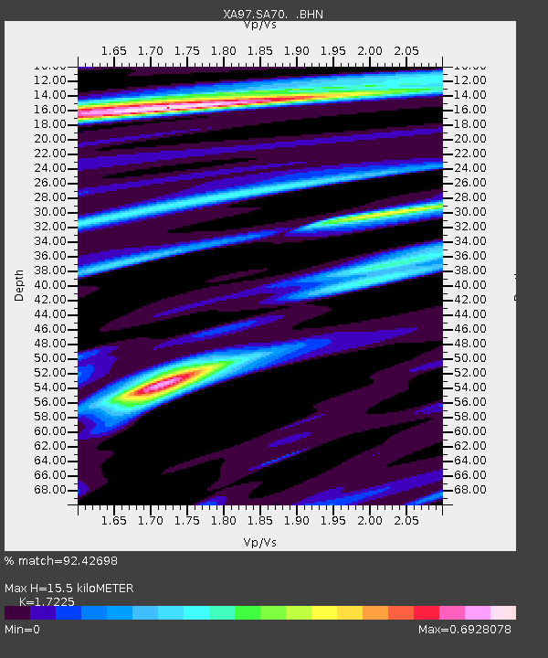
| Estimated Moho Depth: |
15.5 km |
| Estimated Crust Vp/Vs: |
1.72 |
| Assumed Crust Vp: |
6.459 km/s |
| Estimated Crust Vs: |
3.75 km/s |
| Estimated Crust Poisson's Ratio: |
0.25 |
|
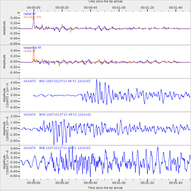
| Radial Match: |
92.42698 % |
| Radial Bump: |
398 |
| Transverse Match: |
59.157185 % |
| Transverse Bump: |
400 |
| SOD ConfigId: |
6273 |
| Insert Time: |
2010-02-26 18:29:13.153 +0000 |
| GWidth: |
2.5 |
| Max Bumps: |
400 |
| Tol: |
0.001 |
|
Signal To Noise
| Channel | StoN | STA | LTA |
| XA:SA70: :BHN:19971013T13:48:52.191016Z | 2.088021 | 1.8432794E-7 | 8.8278775E-8 |
| XA:SA70: :BHE:19971013T13:48:52.191016Z | 0.9597939 | 1.7945364E-7 | 1.86971E-7 |
| XA:SA70: :BHZ:19971013T13:48:52.191016Z | 2.6904926 | 4.3732655E-7 | 1.6254516E-7 |
| Arrivals |
| Ps | 1.8 SECOND |
| PpPs | 6.2 SECOND |
| PsPs/PpSs | 8.0 SECOND |


