
Station XA SA70 - XA.SA70
Network: XA97 - Anatomy of an Archean Craton, South Africa
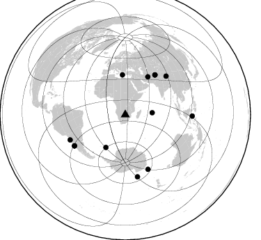
Nearby stations (2 deg radius)
| Station | Name | (Lat, Lon) | Start / End | Elevation |
| SA70 | XA.SA70 | (-21.09, 26.34) | 1997-05-02 / 1999-12-31 | 990 m |
| Crust2 Type: | G1,Archean, no seds. |
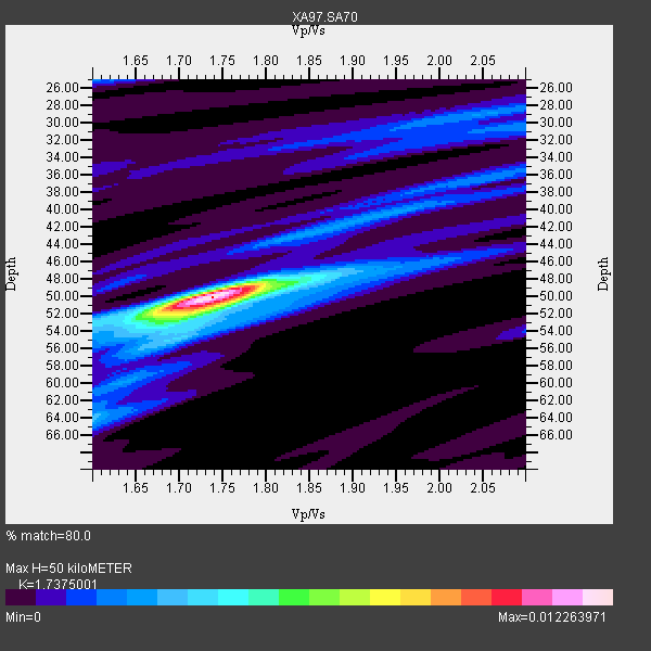
| Thickness Estimate: | 50 km |
| Thickness StdDev: | 4.1 km |
| Vp/Vs Estimate: | 1.74 |
| Vp/Vs StdDev: | 0.03 |
| Vs Estimate: | 3.718 km/s |
| Poisson's Ratio: | 0.25 |
| Peak Value: | 0.01 |
| Assumed Vp: | 6.459 km/s |
| Ps Weight: | 0.33333334 |
| PpPs Weight: | 0.33333334 |
| PsPs Weight: | 0.33333328 |
| Residual Complexity: | 0.445 |
| Nearby stations H: | +- |
| (2.0 deg) Vp/Vs: | +- |
9 with match > 90% ( 34.615383 %) and 13 with match > 80% ( 50.0 %) out of 26.
Download stack as xyz text file.
Azimuth Distribution of Events:
Prior Results for this Station
| Study | Thickness | Vp/Vs | Vp | Vs | Poissons Ratio | Extra |
| EARS | 50 km | 1.74 | 6.459 km/s | 3.718 km/s | 0.25 | |
| Crust2.0 | 37 km | 1.76 | 6.459 km/s | 3.665 km/s | 0.26 | G1,Archean, no seds. |
| Global Maxima | 50 km | 1.74 | 6.459 km/s | 3.718 km/s | 0.25 | amp=0.012263971 |
| Local Maxima 1 | 52 km | 1.70 | 6.459 km/s | 3.8 km/s | 0.24 | amp=0.0041414956 |
| Local Maxima 2 | 64 km | 1.60 | 6.459 km/s | 4.037 km/s | 0.18 | amp=0.0031988632 |
| Local Maxima 3 | 29 km | 2.06 | 6.459 km/s | 3.136 km/s | 0.35 | amp=0.0025066447 |
| Local Maxima 4 | 52 km | 1.80 | 6.459 km/s | 3.584 km/s | 0.28 | amp=0.0022494318 |
| Predicted Arrivals for vertical incidence (zero ray parameter) | |
| Ps | 5.71 SECOND |
| PpPs | 21.19 SECOND |
| PsPs/PpSs | 26.90 SECOND |
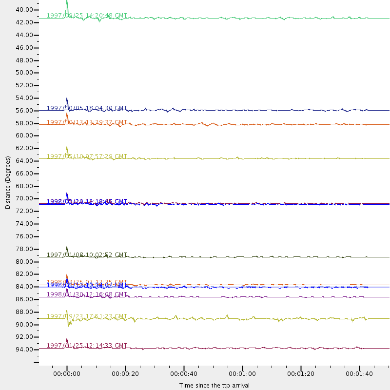
Events Processed for this Station
Download zip of receiver functions as SAC
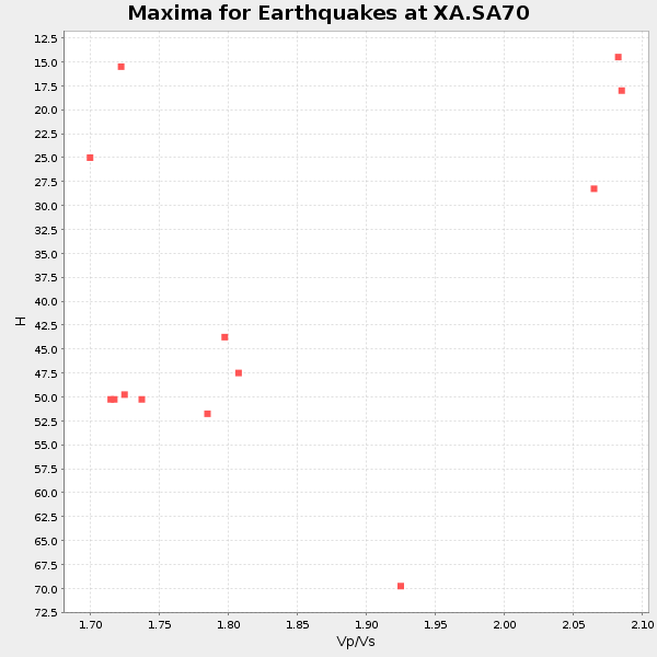
Plot maxima for each earthquake.
Events Used in the Stack
(13 events)| Radial Match | Distance | Baz | FERegion | Time | Lat/Lon | Depth | Magnitude |
| 99.29824 | 85.2 deg | 157.363 deg | Balleny Islands Region | 1998/03/25 03:12:25 GMT | (-62.9, 149.5) | 10 km | 6.6 MB, 8.0 MS, 8.3 UNKNOWN, 8.1 MW |
| 98.26221 | 85.6 deg | 238.693 deg | Near Coast Of Central Chile | 1997/10/15 01:03:33 GMT | (-30.9, -71.2) | 58 km | 6.8 MB, 6.8 MS, 7.3 UNKNOWN, 7.1 MW |
| 98.10228 | 87.3 deg | 245.534 deg | Near Coast Of Northern Chile | 1998/01/30 12:16:08 GMT | (-23.9, -70.2) | 42 km | 6.3 MB, 6.5 MS, 7.0 UNKNOWN, 6.7 ME |
| 97.65595 | 63.2 deg | 30.945 deg | Northern And Central Iran | 1997/05/10 07:57:29 GMT | (33.8, 59.8) | 10 km | 6.4 MB, 7.3 MS, 7.5 UNKNOWN, 7.2 MW |
| 96.665184 | 80.4 deg | 46.682 deg | Xizang | 1997/11/08 10:02:52 GMT | (35.1, 87.3) | 33 km | 6.2 MB, 7.9 MS, 7.7 UNKNOWN, 7.6 MW |
| 95.06239 | 85.7 deg | 238.584 deg | Near Coast Of Central Chile | 1998/01/12 10:14:07 GMT | (-31.0, -71.4) | 35 km | 5.8 MB, 6.2 MS, 6.6 UNKNOWN, 6.2 ME |
| 93.662315 | 96.2 deg | 91.069 deg | Minahassa Peninsula, Sulawesi | 1997/11/25 12:14:33 GMT | (1.2, 122.5) | 24 km | 6.1 MB, 6.8 MS, 7.1 UNKNOWN, 6.7 ME |
| 93.427444 | 71.0 deg | 36.799 deg | Hindu Kush Region, Afghanistan | 1997/05/13 14:13:45 GMT | (36.4, 70.9) | 196 km | 6.1 MB, 6.5 UNKNOWN, 6.4 MW |
| 92.42698 | 57.3 deg | 355.911 deg | Southern Greece | 1997/10/13 13:39:37 GMT | (36.4, 22.1) | 24 km | 6.2 MB, 6.6 MS, 6.7 UNKNOWN, 6.5 MW |
| 89.74414 | 38.7 deg | 85.793 deg | Mid-Indian Ridge | 1997/09/25 14:20:48 GMT | (-13.8, 66.2) | 10 km | 5.3 MB, 5.7 MS, 6.0 UNKNOWN, 6.0 MW |
| 88.36624 | 71.2 deg | 36.835 deg | Afghanistan-Tajikistan Bord Reg. | 1998/02/20 12:18:06 GMT | (36.5, 71.1) | 236 km | 5.8 MB, 5.7 MS, 6.4 UNKNOWN, 6.3 MW |
| 85.31497 | 54.8 deg | 210.72 deg | South Sandwich Islands Region | 1997/10/05 18:04:30 GMT | (-59.7, -29.2) | 274 km | 6.0 MB, 6.3 UNKNOWN, 6.3 MW |
| 80.458954 | 91.1 deg | 168.899 deg | Balleny Islands Region | 1997/09/23 17:51:23 GMT | (-65.5, 178.8) | 10 km | 5.9 MS, 5.0 MB |
Losers
(13 events)| Radial Match | Distance | Baz | FERegion | Time | Lat/Lon | Depth | Magnitude | Reason |
| 78.282585 | 58.6 deg | 354.714 deg | Ionian Sea | 1997/11/18 13:07:41 GMT | (37.6, 20.7) | 33 km | 5.9 MB, 6.4 MS, 6.7 UNKNOWN, 6.1 ML | |
| 74.69089 | 86.4 deg | 239.292 deg | Near Coast Of Central Chile | 1997/07/06 09:54:00 GMT | (-30.1, -71.9) | 19 km | 5.8 MB, 6.5 MS, 6.8 UNKNOWN, 6.4 ME | |
| 73.04448 | 39.8 deg | 239.548 deg | Southern Mid-Atlantic Ridge | 1998/01/03 06:10:08 GMT | (-35.5, -16.2) | 10 km | 5.9 MS, 5.4 MB, 6.3 UNKNOWN, 6.1 MW | |
| 71.69083 | 68.3 deg | 53.013 deg | Southern India | 1997/05/21 22:51:28 GMT | (23.1, 80.0) | 36 km | 6.0 MB, 5.6 MS, 5.8 UNKNOWN, 5.6 ME | |
| 68.60022 | 82.8 deg | 93.335 deg | Java Sea | 1997/07/11 09:55:12 GMT | (-5.7, 110.8) | 574 km | 5.6 MB | |
| 66.323586 | 86.2 deg | 238.871 deg | Near Coast Of Central Chile | 1997/07/27 05:21:29 GMT | (-30.5, -71.9) | 33 km | 5.6 MB, 5.8 MS, 6.3 UNKNOWN, 6.2 MW | |
| 65.93448 | 86.3 deg | 239.028 deg | Near Coast Of Central Chile | 1997/07/21 23:19:39 GMT | (-30.3, -71.9) | 33 km | 5.2 MB, 5.5 MS, 6.1 UNKNOWN | |
| 65.02901 | 87.1 deg | 249.569 deg | Chile-Bolivia Border Region | 1997/12/09 14:23:45 GMT | (-20.2, -68.4) | 133 km | 5.7 MB, 5.7 UNKNOWN, 5.7 MW | |
| 63.686676 | 89.8 deg | 255.437 deg | Peru-Bolivia Border Region | 1997/11/28 22:53:41 GMT | (-13.7, -68.8) | 586 km | 6.4 MB, 6.6 UNKNOWN, 6.6 MW | |
| 61.27908 | 86.5 deg | 240.073 deg | Near Coast Of Central Chile | 1997/07/19 12:22:57 GMT | (-29.3, -71.7) | 26 km | 5.8 MB, 5.5 MS, 5.9 UNKNOWN, 5.8 MW | |
| 59.443474 | 85.5 deg | 242.753 deg | Northern Chile | 1997/05/17 02:10:18 GMT | (-27.2, -69.5) | 106 km | 5.5 MB, 5.6 UNKNOWN, 5.5 MW | |
| 58.39915 | 84.3 deg | 247.693 deg | Jujuy Province, Argentina | 1997/07/20 10:14:22 GMT | (-23.0, -66.3) | 256 km | 5.7 MB, 6.1 UNKNOWN, 5.7 ME | |
| 51.393993 | 86.4 deg | 247.524 deg | Northern Chile | 1997/09/28 23:13:13 GMT | (-22.4, -68.4) | 107 km | 5.7 MB, 5.6 UNKNOWN, 5.6 MW |
