You are here: Home > Network List > XA97 - Anatomy of an Archean Craton, South Africa Stations List
> Station SA70 XA.SA70 > Earthquake Result Viewer
SA70 XA.SA70 - Earthquake Result Viewer
| Earthquake location: |
Balleny Islands Region |
| Earthquake latitude/longitude: |
-62.9/149.5 |
| Earthquake time(UTC): |
1998/03/25 (084) 03:12:25 GMT |
| Earthquake Depth: |
10 km |
| Earthquake Magnitude: |
6.6 MB, 8.0 MS, 8.3 UNKNOWN, 8.1 MW |
| Earthquake Catalog/Contributor: |
WHDF/NEIC |
|
| Network: |
XA Anatomy of an Archean Craton, South Africa |
| Station: |
SA70 XA.SA70 |
| Lat/Lon: |
21.09 S/26.34 E |
| Elevation: |
990 m |
|
| Distance: |
85.2 deg |
| Az: |
231.648 deg |
| Baz: |
157.363 deg |
| Ray Param: |
0.04493267 |
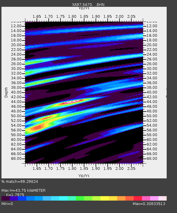
| Estimated Moho Depth: |
43.75 km |
| Estimated Crust Vp/Vs: |
1.80 |
| Assumed Crust Vp: |
6.459 km/s |
| Estimated Crust Vs: |
3.594 km/s |
| Estimated Crust Poisson's Ratio: |
0.28 |
|
| Radial Match: |
99.29824 % |
| Radial Bump: |
205 |
| Transverse Match: |
95.36193 % |
| Transverse Bump: |
400 |
| SOD ConfigId: |
6273 |
| Insert Time: |
2010-02-26 18:29:29.225 +0000 |
| GWidth: |
2.5 |
| Max Bumps: |
400 |
| Tol: |
0.001 |
|
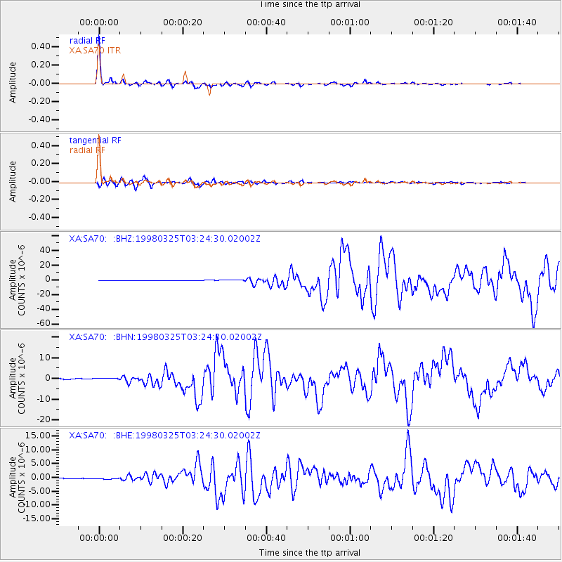
Signal To Noise
| Channel | StoN | STA | LTA |
| XA:SA70: :BHN:19980325T03:24:30.02002Z | 2.9730933 | 4.360074E-7 | 1.466511E-7 |
| XA:SA70: :BHE:19980325T03:24:30.02002Z | 2.1284478 | 1.9319062E-7 | 9.0765965E-8 |
| XA:SA70: :BHZ:19980325T03:24:30.02002Z | 5.468497 | 9.552813E-7 | 1.7468808E-7 |
| Arrivals |
| Ps | 5.5 SECOND |
| PpPs | 18 SECOND |
| PsPs/PpSs | 24 SECOND |


