You are here: Home > Network List > IC - New China Digital Seismograph Network Stations List
> Station HIA Hailar, Neimenggu Autonomous Region, China > Earthquake Result Viewer
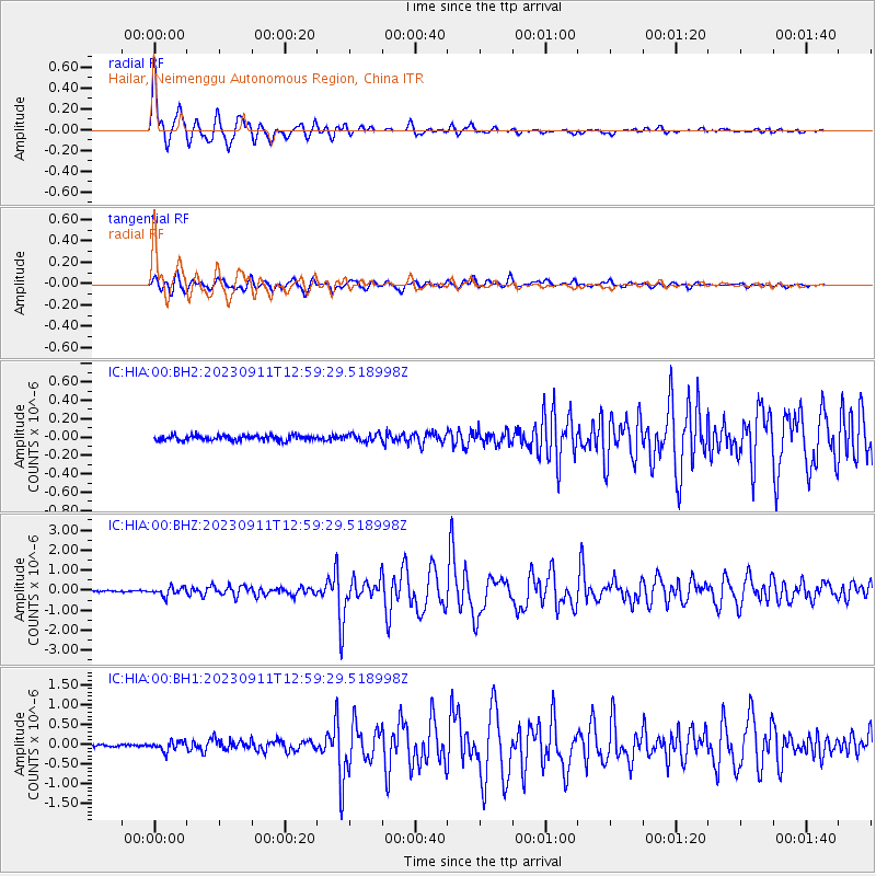
HIA Hailar, Neimenggu Autonomous Region, China - Earthquake Result Viewer
| Earthquake location: |
Halmahera, Indonesia |
| Earthquake latitude/longitude: |
1.1/127.5 |
| Earthquake time(UTC): |
2023/09/11 (254) 12:51:34 GMT |
| Earthquake Depth: |
163 km |
| Earthquake Magnitude: |
6.0 mww |
| Earthquake Catalog/Contributor: |
NEIC PDE/us |
|
| Network: |
IC New China Digital Seismograph Network |
| Station: |
HIA Hailar, Neimenggu Autonomous Region, China |
| Lat/Lon: |
49.27 N/119.74 E |
| Elevation: |
620 m |
|
| Distance: |
48.4 deg |
| Az: |
353.229 deg |
| Baz: |
169.633 deg |
| Ray Param: |
0.06878664 |
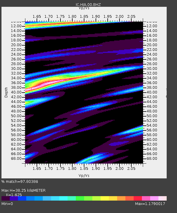
| Estimated Moho Depth: |
38.25 km |
| Estimated Crust Vp/Vs: |
1.62 |
| Assumed Crust Vp: |
6.577 km/s |
| Estimated Crust Vs: |
4.047 km/s |
| Estimated Crust Poisson's Ratio: |
0.20 |
|
| Radial Match: |
97.80386 % |
| Radial Bump: |
364 |
| Transverse Match: |
93.47724 % |
| Transverse Bump: |
400 |
| SOD ConfigId: |
31937991 |
| Insert Time: |
2023-09-25 13:01:40.232 +0000 |
| GWidth: |
2.5 |
| Max Bumps: |
400 |
| Tol: |
0.001 |
|
Signal To Noise
| Channel | StoN | STA | LTA |
| IC:HIA:00:BHZ:20230911T12:59:29.518998Z | 5.7100677 | 2.0881357E-7 | 3.6569368E-8 |
| IC:HIA:00:BH1:20230911T12:59:29.518998Z | 4.2287245 | 1.1652364E-7 | 2.7555268E-8 |
| IC:HIA:00:BH2:20230911T12:59:29.518998Z | 1.5274044 | 4.174359E-8 | 2.7329754E-8 |
| Arrivals |
| Ps | 3.9 SECOND |
| PpPs | 14 SECOND |
| PsPs/PpSs | 18 SECOND |


