You are here: Home > Network List > XA97 - Anatomy of an Archean Craton, South Africa Stations List
> Station SA71 XA.SA71 > Earthquake Result Viewer
SA71 XA.SA71 - Earthquake Result Viewer
| Earthquake location: |
South Sandwich Islands Region |
| Earthquake latitude/longitude: |
-59.7/-29.2 |
| Earthquake time(UTC): |
1997/10/05 (278) 18:04:30 GMT |
| Earthquake Depth: |
274 km |
| Earthquake Magnitude: |
6.0 MB, 6.3 UNKNOWN, 6.3 MW |
| Earthquake Catalog/Contributor: |
WHDF/NEIC |
|
| Network: |
XA Anatomy of an Archean Craton, South Africa |
| Station: |
SA71 XA.SA71 |
| Lat/Lon: |
20.93 S/27.14 E |
| Elevation: |
1072 m |
|
| Distance: |
55.3 deg |
| Az: |
71.063 deg |
| Baz: |
210.827 deg |
| Ray Param: |
0.06387309 |
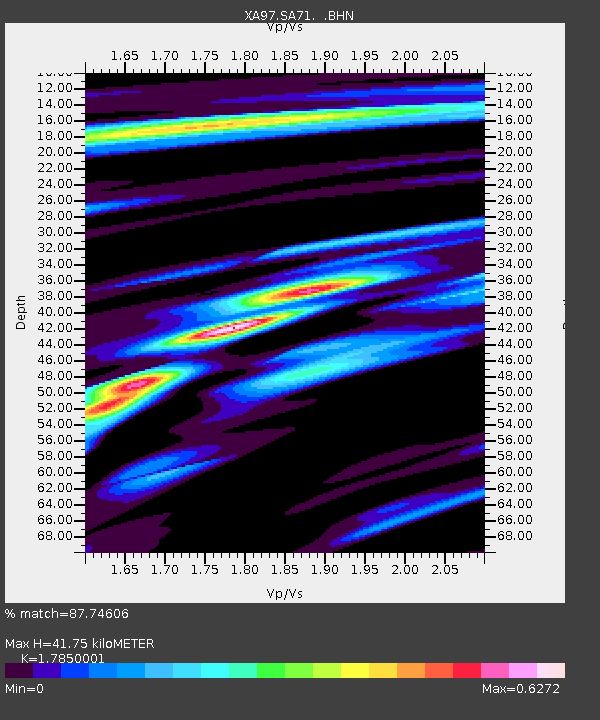
| Estimated Moho Depth: |
41.75 km |
| Estimated Crust Vp/Vs: |
1.79 |
| Assumed Crust Vp: |
6.459 km/s |
| Estimated Crust Vs: |
3.619 km/s |
| Estimated Crust Poisson's Ratio: |
0.27 |
|
| Radial Match: |
87.74606 % |
| Radial Bump: |
357 |
| Transverse Match: |
63.49851 % |
| Transverse Bump: |
400 |
| SOD ConfigId: |
6273 |
| Insert Time: |
2010-02-26 18:29:55.304 +0000 |
| GWidth: |
2.5 |
| Max Bumps: |
400 |
| Tol: |
0.001 |
|
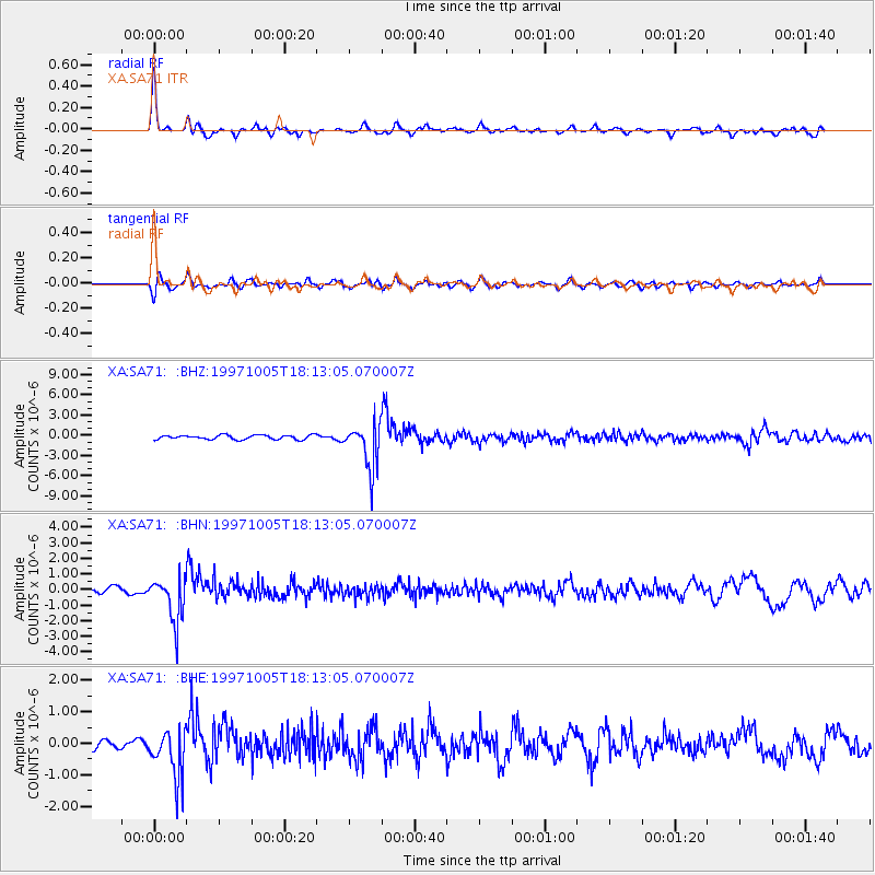
Signal To Noise
| Channel | StoN | STA | LTA |
| XA:SA71: :BHN:19971005T18:13:05.070007Z | 5.9931464 | 1.4607629E-6 | 2.4373887E-7 |
| XA:SA71: :BHE:19971005T18:13:05.070007Z | 6.0690174 | 7.815508E-7 | 1.2877716E-7 |
| XA:SA71: :BHZ:19971005T18:13:05.070007Z | 10.700274 | 3.3714086E-6 | 3.1507685E-7 |
| Arrivals |
| Ps | 5.3 SECOND |
| PpPs | 17 SECOND |
| PsPs/PpSs | 22 SECOND |


