
Station XA SA71 - XA.SA71
Network: XA97 - Anatomy of an Archean Craton, South Africa
Nearby stations (2 deg radius)
| Station | Name | (Lat, Lon) | Start / End | Elevation |
| SA71 | XA.SA71 | (-20.93, 27.14) | 1997-04-28 / 1999-12-31 | 1072 m |
| Crust2 Type: | G1,Archean, no seds. |
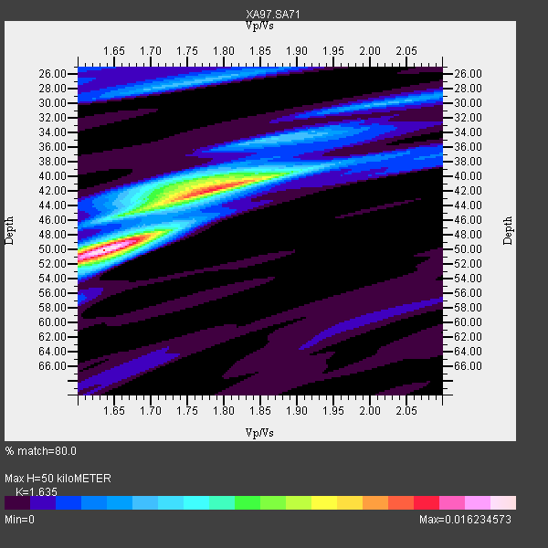
| Thickness Estimate: | 50 km |
| Thickness StdDev: | 4.3 km |
| Vp/Vs Estimate: | 1.63 |
| Vp/Vs StdDev: | 0.09 |
| Vs Estimate: | 3.951 km/s |
| Poisson's Ratio: | 0.20 |
| Peak Value: | 0.02 |
| Assumed Vp: | 6.459 km/s |
| Ps Weight: | 0.33333334 |
| PpPs Weight: | 0.33333334 |
| PsPs Weight: | 0.33333328 |
| Residual Complexity: | 0.739 |
| Nearby stations H: | +- |
| (2.0 deg) Vp/Vs: | +- |
6 with match > 90% ( 28.571428 %) and 10 with match > 80% ( 47.61905 %) out of 21.
Download stack as xyz text file.
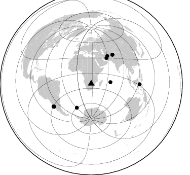
Azimuth Distribution of Events:
Prior Results for this Station
| Study | Thickness | Vp/Vs | Vp | Vs | Poissons Ratio | Extra |
| EARS | 50 km | 1.63 | 6.459 km/s | 3.951 km/s | 0.20 | |
| Crust2.0 | 37 km | 1.76 | 6.459 km/s | 3.665 km/s | 0.26 | G1,Archean, no seds. |
| Global Maxima | 50 km | 1.63 | 6.459 km/s | 3.951 km/s | 0.20 | amp=0.016234573 |
| Local Maxima 1 | 42 km | 1.80 | 6.459 km/s | 3.599 km/s | 0.27 | amp=0.012206227 |
| Local Maxima 2 | 41 km | 1.75 | 6.459 km/s | 3.691 km/s | 0.26 | amp=0.006629739 |
| Local Maxima 3 | 27 km | 1.75 | 6.459 km/s | 3.691 km/s | 0.26 | amp=0.0046642455 |
| Local Maxima 4 | 52 km | 1.60 | 6.459 km/s | 4.031 km/s | 0.18 | amp=0.0034623884 |
| Predicted Arrivals for vertical incidence (zero ray parameter) | |
| Ps | 4.92 SECOND |
| PpPs | 20.40 SECOND |
| PsPs/PpSs | 25.31 SECOND |
Events Processed for this Station
Download zip of receiver functions as SAC
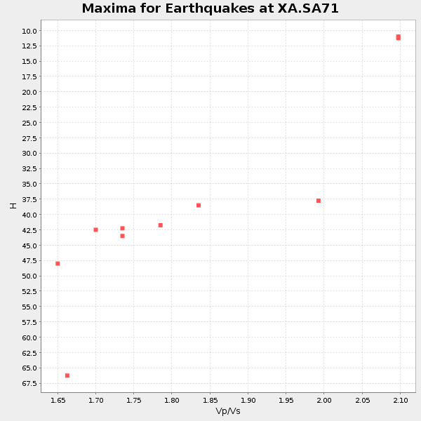
Plot maxima for each earthquake.
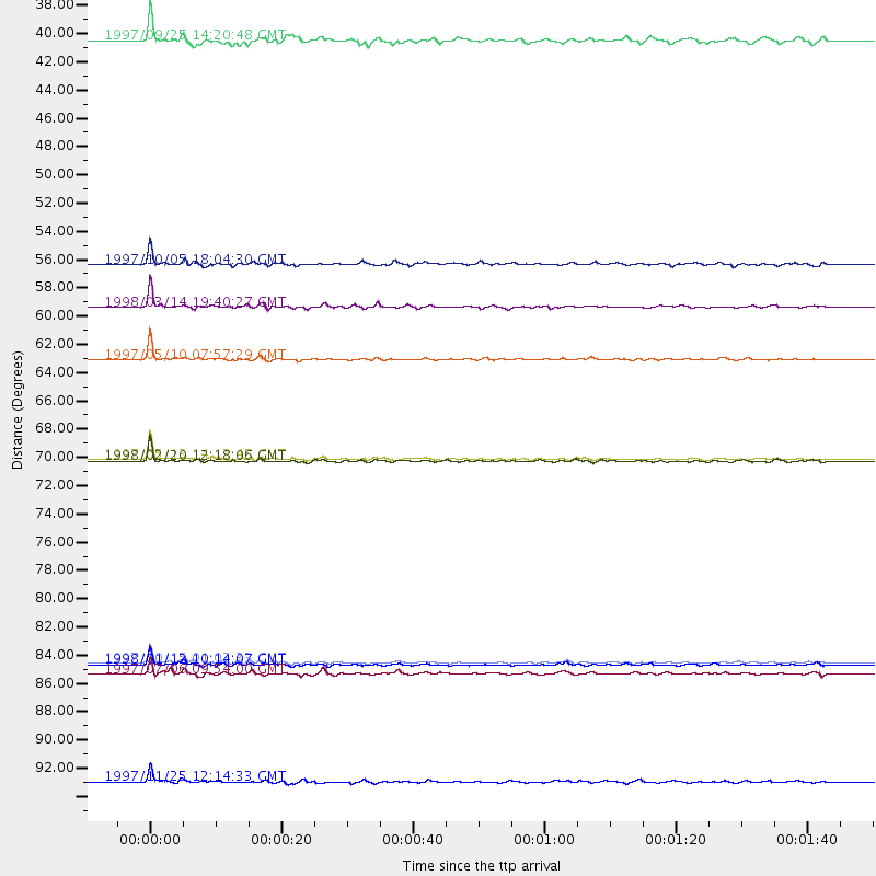
Events Used in the Stack
(10 events)| Radial Match | Distance | Baz | FERegion | Time | Lat/Lon | Depth | Magnitude |
| 97.81187 | 86.3 deg | 238.424 deg | Near Coast Of Central Chile | 1997/10/15 01:03:33 GMT | (-30.9, -71.2) | 58 km | 6.8 MB, 6.8 MS, 7.3 UNKNOWN, 7.1 MW |
| 97.07474 | 62.7 deg | 30.37 deg | Northern And Central Iran | 1997/05/10 07:57:29 GMT | (33.8, 59.8) | 10 km | 6.4 MB, 7.3 MS, 7.5 UNKNOWN, 7.2 MW |
| 95.54825 | 70.5 deg | 36.334 deg | Hindu Kush Region, Afghanistan | 1997/05/13 14:13:45 GMT | (36.4, 70.9) | 196 km | 6.1 MB, 6.5 UNKNOWN, 6.4 MW |
| 92.37274 | 86.4 deg | 238.314 deg | Near Coast Of Central Chile | 1998/01/12 10:14:07 GMT | (-31.0, -71.4) | 35 km | 5.8 MB, 6.2 MS, 6.6 UNKNOWN, 6.2 ME |
| 91.144905 | 58.6 deg | 30.949 deg | Northern And Central Iran | 1998/03/14 19:40:27 GMT | (30.2, 57.6) | 9.0 km | 5.9 MB, 6.9 MS, 6.6 UNKNOWN, 6.3 ME |
| 90.00587 | 70.6 deg | 36.372 deg | Afghanistan-Tajikistan Bord Reg. | 1998/02/20 12:18:06 GMT | (36.5, 71.1) | 236 km | 5.8 MB, 5.7 MS, 6.4 UNKNOWN, 6.3 MW |
| 87.76261 | 95.5 deg | 90.764 deg | Minahassa Peninsula, Sulawesi | 1997/11/25 12:14:33 GMT | (1.2, 122.5) | 24 km | 6.1 MB, 6.8 MS, 7.1 UNKNOWN, 6.7 ME |
| 87.74606 | 55.3 deg | 210.827 deg | South Sandwich Islands Region | 1997/10/05 18:04:30 GMT | (-59.7, -29.2) | 274 km | 6.0 MB, 6.3 UNKNOWN, 6.3 MW |
| 82.461 | 87.1 deg | 239.019 deg | Near Coast Of Central Chile | 1997/07/06 09:54:00 GMT | (-30.1, -71.9) | 19 km | 5.8 MB, 6.5 MS, 6.8 UNKNOWN, 6.4 ME |
| 81.42994 | 37.9 deg | 85.638 deg | Mid-Indian Ridge | 1997/09/25 14:20:48 GMT | (-13.8, 66.2) | 10 km | 5.3 MB, 5.7 MS, 6.0 UNKNOWN, 6.0 MW |
Losers
(11 events)| Radial Match | Distance | Baz | FERegion | Time | Lat/Lon | Depth | Magnitude | Reason |
| 80.02827 | 62.7 deg | 30.041 deg | Northern And Central Iran | 1997/06/25 19:38:40 GMT | (33.9, 59.5) | 10 km | 5.5 MB, 5.8 MS, 6.0 UNKNOWN, 5.9 MW | |
| 78.5892 | 82.1 deg | 93.075 deg | Java Sea | 1997/07/11 09:55:12 GMT | (-5.7, 110.8) | 574 km | 5.6 MB | |
| 73.809425 | 87.3 deg | 239.798 deg | Near Coast Of Central Chile | 1997/07/19 12:22:57 GMT | (-29.3, -71.7) | 26 km | 5.8 MB, 5.5 MS, 5.9 UNKNOWN, 5.8 MW | |
| 70.4346 | 85.1 deg | 247.418 deg | Jujuy Province, Argentina | 1997/07/20 10:14:22 GMT | (-23.0, -66.3) | 256 km | 5.7 MB, 6.1 UNKNOWN, 5.7 ME | |
| 68.73531 | 49.0 deg | 127.558 deg | Mid-Indian Ridge | 1997/08/20 13:51:16 GMT | (-41.7, 80.1) | 10 km | 5.6 MB, 6.4 MS, 6.5 UNKNOWN, 6.4 MW | |
| 66.67072 | 67.6 deg | 52.594 deg | Southern India | 1997/05/21 22:51:28 GMT | (23.1, 80.0) | 36 km | 6.0 MB, 5.6 MS, 5.8 UNKNOWN, 5.6 ME | |
| 66.12108 | 87.1 deg | 247.245 deg | Northern Chile | 1997/09/28 23:13:13 GMT | (-22.4, -68.4) | 107 km | 5.7 MB, 5.6 UNKNOWN, 5.6 MW | |
| 65.55478 | 77.0 deg | 59.979 deg | India-Bangladesh Border Region | 1997/11/21 11:23:06 GMT | (22.2, 92.7) | 54 km | 5.9 MB, 6.1 UNKNOWN, 6.1 MW | |
| 59.998142 | 87.1 deg | 238.755 deg | Near Coast Of Central Chile | 1997/07/21 23:19:39 GMT | (-30.3, -71.9) | 33 km | 5.2 MB, 5.5 MS, 6.1 UNKNOWN | |
| 57.881588 | 77.6 deg | 319.461 deg | Azores Islands, Portugal | 1997/06/27 04:39:52 GMT | (38.3, -26.7) | 10 km | 5.6 MB, 5.4 MS, 5.9 UNKNOWN, 5.9 MW | |
| 49.002003 | 86.3 deg | 242.481 deg | Northern Chile | 1997/05/17 02:10:18 GMT | (-27.2, -69.5) | 106 km | 5.5 MB, 5.6 UNKNOWN, 5.5 MW |
