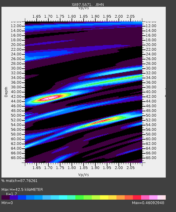
SA71 XA.SA71 - Earthquake Result Viewer
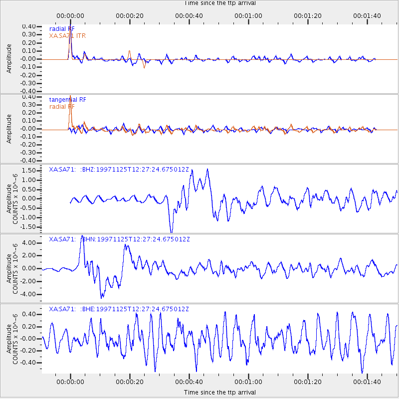
Earthquake location: Minahassa Peninsula, Sulawesi
Earthquake latitude/longitude: 1.2/122.5
Earthquake time(UTC): 1997/11/25 (329) 12:14:33 GMT
Earthquake Depth: 24 km
Earthquake Magnitude: 6.1 MB, 6.8 MS, 7.1 UNKNOWN, 6.7 ME
Earthquake Catalog/Contributor: WHDF/NEIC
Network: XA Anatomy of an Archean Craton, South Africa
Station: SA71 XA.SA71
Lat/Lon: 20.93 S/27.14 E
Elevation: 1072 m
Distance: 95.5 deg
Az: 249.224 deg
Baz: 90.764 deg
Ray Param: 0.04076242
Estimated Moho Depth: 42.5 km
Estimated Crust Vp/Vs: 1.70
Assumed Crust Vp: 6.459 km/s
Estimated Crust Vs: 3.8 km/s
Estimated Crust Poisson's Ratio: 0.24
Radial Match: 87.76261 %
Radial Bump: 278
Transverse Match: 66.2227 %
Transverse Bump: 400
SOD ConfigId: 4480
Insert Time: 2010-02-26 18:30:02.328 +0000
GWidth: 2.5
Max Bumps: 400
Tol: 0.001

Signal To Noise

ChannelStoNSTALTA
XA:SA71: :BHN:19971125T12:27:24.675012Z9.1752542.3035393E-62.5106E-7
XA:SA71: :BHE:19971125T12:27:24.675012Z0.52388129.322183E-81.779446E-7
XA:SA71: :BHZ:19971125T12:27:24.675012Z7.0526867.8728795E-71.1162952E-7
Arrivals
Ps4.7 SECOND
PpPs17 SECOND
PsPs/PpSs22 SECOND