You are here: Home > Network List > XU06 - Cascadia Arrays For Earthscope Stations List
> Station W030 Quilcene, WA, USA > Earthquake Result Viewer
W030 Quilcene, WA, USA - Earthquake Result Viewer
| Earthquake location: |
New Britain Region, P.N.G. |
| Earthquake latitude/longitude: |
-6.0/150.4 |
| Earthquake time(UTC): |
2010/07/18 (199) 13:04:09 GMT |
| Earthquake Depth: |
28 km |
| Earthquake Magnitude: |
6.3 MB, 7.1 MS, 6.9 MW, 6.8 MW |
| Earthquake Catalog/Contributor: |
WHDF/NEIC |
|
| Network: |
XU Cascadia Arrays For Earthscope |
| Station: |
W030 Quilcene, WA, USA |
| Lat/Lon: |
47.81 N/122.91 W |
| Elevation: |
69 m |
|
| Distance: |
92.1 deg |
| Az: |
42.326 deg |
| Baz: |
263.543 deg |
| Ray Param: |
0.041497864 |
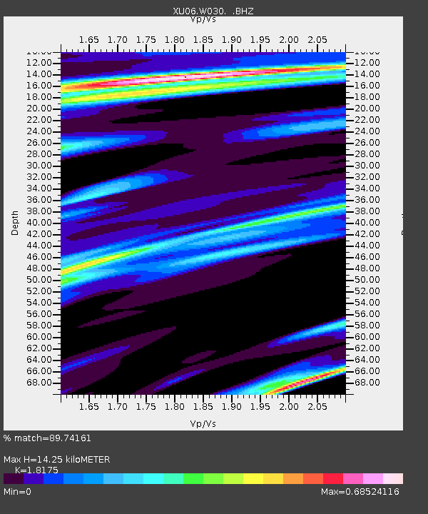
| Estimated Moho Depth: |
14.25 km |
| Estimated Crust Vp/Vs: |
1.82 |
| Assumed Crust Vp: |
6.566 km/s |
| Estimated Crust Vs: |
3.613 km/s |
| Estimated Crust Poisson's Ratio: |
0.28 |
|
| Radial Match: |
89.74161 % |
| Radial Bump: |
400 |
| Transverse Match: |
85.17138 % |
| Transverse Bump: |
400 |
| SOD ConfigId: |
319893 |
| Insert Time: |
2011-01-05 06:40:36.816 +0000 |
| GWidth: |
2.5 |
| Max Bumps: |
400 |
| Tol: |
0.001 |
|

Signal To Noise
| Channel | StoN | STA | LTA |
| XU:W030: :BHZ:20100718T13:16:44.719998Z | 25.764114 | 2.7962208E-6 | 1.0853161E-7 |
| XU:W030: :BHN:20100718T13:16:44.719998Z | 1.2415264 | 1.4023763E-7 | 1.1295583E-7 |
| XU:W030: :BHE:20100718T13:16:44.719998Z | 4.632313 | 5.818829E-7 | 1.256139E-7 |
| Arrivals |
| Ps | 1.8 SECOND |
| PpPs | 6.0 SECOND |
| PsPs/PpSs | 7.8 SECOND |


