
Station XU W030 - Quilcene, WA, USA
Network: XU06 - Cascadia Arrays For Earthscope
Nearby stations (2 deg radius)
| Station | Name | (Lat, Lon) | Start / End | Elevation |
| W030 | Quilcene, WA, USA | (47.81, -122.91) | 2006-10-20 / 2010-12-31 | 69 m |
| Crust2 Type: | L8,thin continental arc, Cordilleras, 0.5 km seds. |
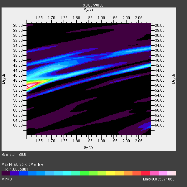
| Thickness Estimate: | 50 km |
| Thickness StdDev: | 4.0 km |
| Vp/Vs Estimate: | 1.60 |
| Vp/Vs StdDev: | 0.08 |
| Vs Estimate: | 4.097 km/s |
| Poisson's Ratio: | 0.18 |
| Peak Value: | 0.04 |
| Assumed Vp: | 6.566 km/s |
| Ps Weight: | 0.33333334 |
| PpPs Weight: | 0.33333334 |
| PsPs Weight: | 0.33333328 |
| Residual Complexity: | 0.614 |
| Nearby stations H: | +- |
| (2.0 deg) Vp/Vs: | +- |
0 with match > 90% ( 0.0 %) and 5 with match > 80% ( 38.46154 %) out of 13.
Download stack as xyz text file.
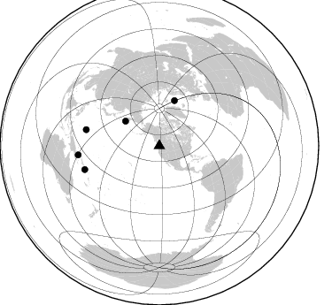
Azimuth Distribution of Events:
Prior Results for this Station
| Study | Thickness | Vp/Vs | Vp | Vs | Poissons Ratio | Extra |
| EARS | 50 km | 1.60 | 6.566 km/s | 4.097 km/s | 0.18 | |
| Crust2.0 | 34 km | 1.77 | 6.566 km/s | 3.707 km/s | 0.27 | L8,thin continental arc, Cordilleras, 0.5 km seds. |
| Global Maxima | 50 km | 1.60 | 6.566 km/s | 4.097 km/s | 0.18 | amp=0.035871863 |
| Local Maxima 1 | 49 km | 1.61 | 6.566 km/s | 4.085 km/s | 0.18 | amp=0.014430184 |
| Local Maxima 2 | 35 km | 2.09 | 6.566 km/s | 3.142 km/s | 0.35 | amp=0.012332335 |
| Local Maxima 3 | 44 km | 1.70 | 6.566 km/s | 3.862 km/s | 0.24 | amp=0.010952637 |
| Local Maxima 4 | 45 km | 1.81 | 6.566 km/s | 3.633 km/s | 0.28 | amp=0.008462578 |
| Predicted Arrivals for vertical incidence (zero ray parameter) | |
| Ps | 4.61 SECOND |
| PpPs | 19.92 SECOND |
| PsPs/PpSs | 24.53 SECOND |
Events Processed for this Station
Download zip of receiver functions as SAC
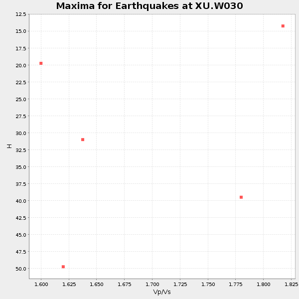
Plot maxima for each earthquake.
Events Used in the Stack
(5 events)| Radial Match | Distance | Baz | FERegion | Time | Lat/Lon | Depth | Magnitude |
| 89.74161 | 92.1 deg | 263.543 deg | New Britain Region, P.N.G. | 2010/07/18 13:04:09 GMT | (-6.0, 150.4) | 28 km | 6.3 MB, 7.1 MS, 6.9 MW, 6.8 MW |
| 88.79506 | 54.0 deg | 18.397 deg | Norwegian Sea | 2009/08/20 06:35:04 GMT | (72.2, 0.9) | 6.0 km | 5.9 MB, 5.7 MS, 6.0 MW, 6.0 MW |
| 86.20724 | 47.5 deg | 306.03 deg | Off East Coast Of Kamchatka | 2010/07/30 03:56:13 GMT | (52.5, 159.8) | 23 km | 6.1 MB, 6.3 MS, 6.3 MW, 6.3 MW |
| 85.70473 | 88.3 deg | 252.32 deg | Solomon Islands | 2010/06/26 05:30:19 GMT | (-10.6, 161.4) | 35 km | 6.4 MB, 6.8 MS, 6.7 MW, 6.6 MW |
| 82.77057 | 84.6 deg | 282.492 deg | South Of Mariana Islands | 2010/08/13 21:19:33 GMT | (12.5, 141.5) | 10 km | 6.5 MB, 6.9 MS, 6.9 MW, 6.9 MW |
Losers
(8 events)| Radial Match | Distance | Baz | FERegion | Time | Lat/Lon | Depth | Magnitude | Reason |
| 79.0989 | 64.7 deg | 301.744 deg | Near East Coast Of Honshu, Japan | 2010/07/04 21:55:51 GMT | (39.7, 142.4) | 27 km | 6.4 MB, 6.1 MS, 6.3 MW, 6.2 MW | |
| 74.60829 | 84.5 deg | 282.329 deg | South Of Mariana Islands | 2010/08/14 07:31:01 GMT | (12.4, 141.6) | 10 km | 5.7 MB | |
| 65.06931 | 94.2 deg | 266.519 deg | Eastern New Guinea Reg., P.N.G. | 2010/08/04 07:15:34 GMT | (-5.5, 146.8) | 226 km | 6.1 MB, 6.5 MW, 6.4 MW | |
| 63.302826 | 89.0 deg | 226.513 deg | South Of Fiji Islands | 2010/08/04 04:46:20 GMT | (-26.9, -177.2) | 18 km | 5.7 MB, 5.8 MS, 6.0 MW, 5.9 MW | |
| 60.13602 | 87.6 deg | 244.406 deg | Vanuatu Islands | 2010/07/22 05:03:57 GMT | (-15.1, 168.2) | 10 km | 6.2 MB, 5.4 MS, 6.1 MW, 5.9 MW | |
| 57.876537 | 93.3 deg | 265.261 deg | New Britain Region, P.N.G. | 2010/08/15 15:09:29 GMT | (-5.7, 148.3) | 175 km | 5.8 MB, 6.3 MW, 6.3 MW | |
| 52.91252 | 86.1 deg | 230.989 deg | South Of Fiji Islands | 2009/06/07 12:46:30 GMT | (-22.0, -179.6) | 590 km | 5.5 MW, 5.1 MB | |
| 42.51171 | 81.1 deg | 280.964 deg | Mariana Islands | 2010/07/10 05:39:43 GMT | (14.0, 145.0) | 136 km | 5.6 MB, 5.6 MW, 5.5 MW |
