You are here: Home > Network List > XA97 - Anatomy of an Archean Craton, South Africa Stations List
> Station SA73 XA.SA73 > Earthquake Result Viewer
SA73 XA.SA73 - Earthquake Result Viewer
| Earthquake location: |
South Sandwich Islands Region |
| Earthquake latitude/longitude: |
-59.7/-29.2 |
| Earthquake time(UTC): |
1997/10/05 (278) 18:04:30 GMT |
| Earthquake Depth: |
274 km |
| Earthquake Magnitude: |
6.0 MB, 6.3 UNKNOWN, 6.3 MW |
| Earthquake Catalog/Contributor: |
WHDF/NEIC |
|
| Network: |
XA Anatomy of an Archean Craton, South Africa |
| Station: |
SA73 XA.SA73 |
| Lat/Lon: |
21.85 S/30.28 E |
| Elevation: |
590 m |
|
| Distance: |
56.1 deg |
| Az: |
74.667 deg |
| Baz: |
211.72 deg |
| Ray Param: |
0.06341162 |
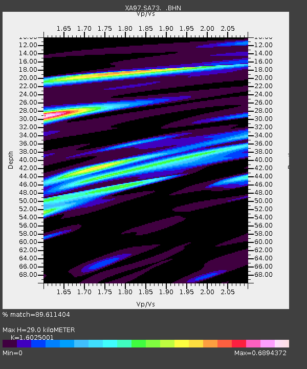
| Estimated Moho Depth: |
29.0 km |
| Estimated Crust Vp/Vs: |
1.60 |
| Assumed Crust Vp: |
6.642 km/s |
| Estimated Crust Vs: |
4.145 km/s |
| Estimated Crust Poisson's Ratio: |
0.18 |
|
| Radial Match: |
89.611404 % |
| Radial Bump: |
400 |
| Transverse Match: |
73.44393 % |
| Transverse Bump: |
400 |
| SOD ConfigId: |
6273 |
| Insert Time: |
2010-02-26 18:30:54.318 +0000 |
| GWidth: |
2.5 |
| Max Bumps: |
400 |
| Tol: |
0.001 |
|

Signal To Noise
| Channel | StoN | STA | LTA |
| XA:SA73: :BHN:19971005T18:13:10.221008Z | 4.823106 | 9.139137E-7 | 1.8948656E-7 |
| XA:SA73: :BHE:19971005T18:13:10.221008Z | 4.345556 | 7.783149E-7 | 1.7910597E-7 |
| XA:SA73: :BHZ:19971005T18:13:10.221008Z | 10.929022 | 2.4798708E-6 | 2.2690693E-7 |
| Arrivals |
| Ps | 2.8 SECOND |
| PpPs | 11 SECOND |
| PsPs/PpSs | 14 SECOND |


