
Station XA SA73 - XA.SA73
Network: XA97 - Anatomy of an Archean Craton, South Africa
Nearby stations (2 deg radius)
| Station | Name | (Lat, Lon) | Start / End | Elevation |
| SA73 | XA.SA73 | (-21.85, 30.28) | 1997-04-14 / 1999-12-31 | 590 m |
| Crust2 Type: | I1,late Proter., no seds. |
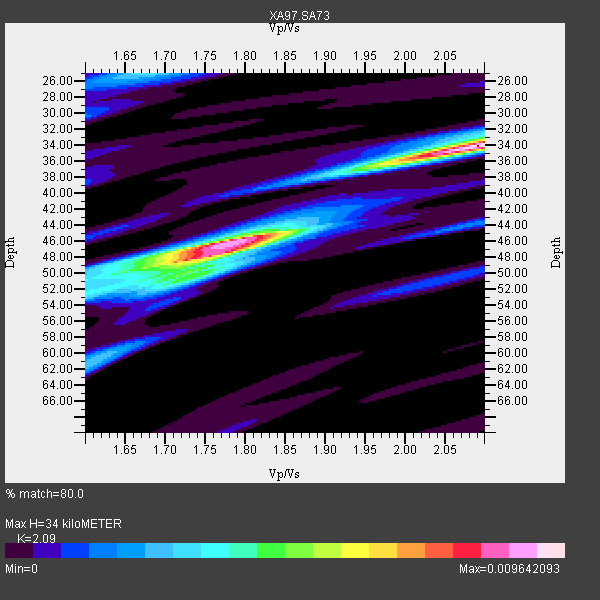
| Thickness Estimate: | 34 km |
| Thickness StdDev: | 8.6 km |
| Vp/Vs Estimate: | 2.09 |
| Vp/Vs StdDev: | 0.15 |
| Vs Estimate: | 3.178 km/s |
| Poisson's Ratio: | 0.35 |
| Peak Value: | 0.01 |
| Assumed Vp: | 6.642 km/s |
| Ps Weight: | 0.33333334 |
| PpPs Weight: | 0.33333334 |
| PsPs Weight: | 0.33333328 |
| Residual Complexity: | 0.795 |
| Nearby stations H: | +- |
| (2.0 deg) Vp/Vs: | +- |
4 with match > 90% ( 15.384615 %) and 8 with match > 80% ( 30.76923 %) out of 26.
Download stack as xyz text file.
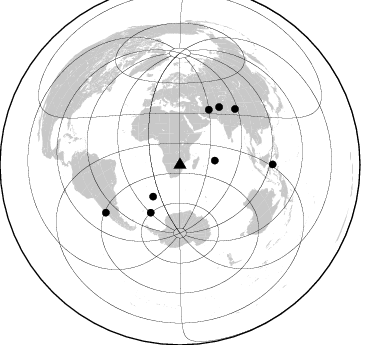
Azimuth Distribution of Events:
Prior Results for this Station
| Study | Thickness | Vp/Vs | Vp | Vs | Poissons Ratio | Extra |
| EARS | 34 km | 2.09 | 6.642 km/s | 3.178 km/s | 0.35 | |
| Crust2.0 | 43 km | 1.77 | 6.642 km/s | 3.756 km/s | 0.26 | I1,late Proter., no seds. |
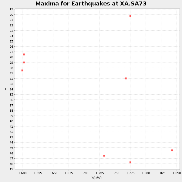
| Global Maxima | 34 km | 2.09 | 6.642 km/s | 3.178 km/s | 0.35 | amp=0.009642093 |
| Local Maxima 1 | 46 km | 1.79 | 6.642 km/s | 3.721 km/s | 0.27 | amp=0.008299075 |
| Local Maxima 2 | 50 km | 1.65 | 6.642 km/s | 4.031 km/s | 0.21 | amp=0.0037437999 |
| Local Maxima 3 | 50 km | 1.71 | 6.642 km/s | 3.896 km/s | 0.24 | amp=0.0031490226 |
| Local Maxima 4 | 25 km | 1.67 | 6.642 km/s | 3.971 km/s | 0.22 | amp=0.0031108493 |
| Predicted Arrivals for vertical incidence (zero ray parameter) | |
| Ps | 5.58 SECOND |
| PpPs | 15.82 SECOND |
| PsPs/PpSs | 21.40 SECOND |
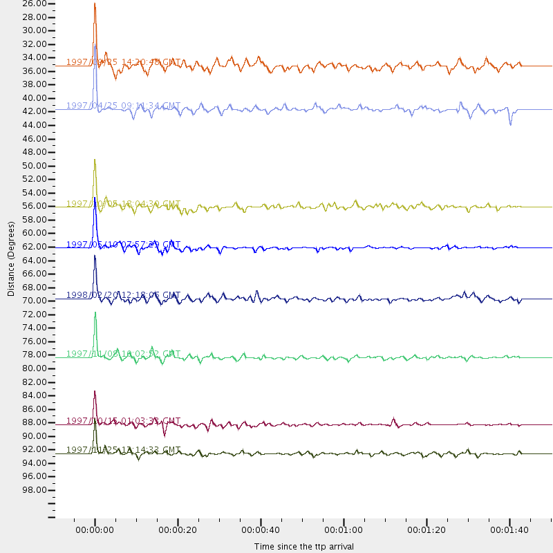
Events Processed for this Station
Download zip of receiver functions as SAC
Plot maxima for each earthquake.
Events Used in the Stack
(8 events)| Radial Match | Distance | Baz | FERegion | Time | Lat/Lon | Depth | Magnitude |
| 98.164314 | 88.3 deg | 237.397 deg | Near Coast Of Central Chile | 1997/10/15 01:03:33 GMT | (-30.9, -71.2) | 58 km | 6.8 MB, 6.8 MS, 7.3 UNKNOWN, 7.1 MW |
| 98.147545 | 62.1 deg | 27.662 deg | Northern And Central Iran | 1997/05/10 07:57:29 GMT | (33.8, 59.8) | 10 km | 6.4 MB, 7.3 MS, 7.5 UNKNOWN, 7.2 MW |
| 96.58378 | 78.3 deg | 44.661 deg | Xizang | 1997/11/08 10:02:52 GMT | (35.1, 87.3) | 33 km | 6.2 MB, 7.9 MS, 7.7 UNKNOWN, 7.6 MW |
| 93.274445 | 92.6 deg | 89.69 deg | Minahassa Peninsula, Sulawesi | 1997/11/25 12:14:33 GMT | (1.2, 122.5) | 24 km | 6.1 MB, 6.8 MS, 7.1 UNKNOWN, 6.7 ME |
| 89.611404 | 56.1 deg | 211.72 deg | South Sandwich Islands Region | 1997/10/05 18:04:30 GMT | (-59.7, -29.2) | 274 km | 6.0 MB, 6.3 UNKNOWN, 6.3 MW |
| 88.99441 | 69.7 deg | 34.179 deg | Afghanistan-Tajikistan Bord Reg. | 1998/02/20 12:18:06 GMT | (36.5, 71.1) | 236 km | 5.8 MB, 5.7 MS, 6.4 UNKNOWN, 6.3 MW |
| 84.74741 | 41.6 deg | 220.594 deg | Southern Mid-Atlantic Ridge | 1997/04/25 09:11:34 GMT | (-48.3, -10.0) | 10 km | 5.8 MS, 5.3 MB, 5.8 UNKNOWN, 5.7 MW |
| 81.226654 | 35.1 deg | 82.865 deg | Mid-Indian Ridge | 1997/09/25 14:20:48 GMT | (-13.8, 66.2) | 10 km | 5.3 MB, 5.7 MS, 6.0 UNKNOWN, 6.0 MW |
Losers
(18 events)| Radial Match | Distance | Baz | FERegion | Time | Lat/Lon | Depth | Magnitude | Reason |
| 84.88041 | 90.2 deg | 248.182 deg | Chile-Bolivia Border Region | 1997/12/09 14:23:45 GMT | (-20.2, -68.4) | 133 km | 5.7 MB, 5.7 UNKNOWN, 5.7 MW | |
| 77.5107 | 65.9 deg | 50.364 deg | Southern India | 1997/05/21 22:51:28 GMT | (23.1, 80.0) | 36 km | 6.0 MB, 5.6 MS, 5.8 UNKNOWN, 5.6 ME | |
| 77.29118 | 88.4 deg | 237.567 deg | Near Coast Of Central Chile | 1997/11/03 19:17:33 GMT | (-30.7, -71.2) | 45 km | 6.2 MB, 5.6 MS, 6.3 UNKNOWN, 5.8 MD | |
| 74.56065 | 80.2 deg | 318.012 deg | Azores Islands, Portugal | 1997/06/27 04:39:52 GMT | (38.3, -26.7) | 10 km | 5.6 MB, 5.4 MS, 5.9 UNKNOWN, 5.9 MW | |
| 71.5966 | 86.1 deg | 234.989 deg | Chile-Argentina Border Region | 1997/04/20 19:53:15 GMT | (-34.0, -70.0) | 105 km | 5.6 UNKNOWN, 5.3 MB, 5.5 MD | |
| 68.53075 | 89.1 deg | 237.957 deg | Near Coast Of Central Chile | 1997/07/06 09:54:00 GMT | (-30.1, -71.9) | 19 km | 5.8 MB, 6.5 MS, 6.8 UNKNOWN, 6.4 ME | |
| 64.432755 | 87.4 deg | 246.413 deg | Jujuy Province, Argentina | 1997/07/20 10:14:22 GMT | (-23.0, -66.3) | 256 km | 5.7 MB, 6.1 UNKNOWN, 5.7 ME | |
| 64.081245 | 46.1 deg | 127.379 deg | Mid-Indian Ridge | 1997/08/20 13:51:16 GMT | (-41.7, 80.1) | 10 km | 5.6 MB, 6.4 MS, 6.5 UNKNOWN, 6.4 MW | |
| 63.7727 | 71.9 deg | 86.337 deg | Southern Sumatra, Indonesia | 1997/04/22 05:55:59 GMT | (-3.4, 102.1) | 108 km | 5.6 MB, 5.9 UNKNOWN, 5.9 MW | |
| 63.07296 | 97.3 deg | 100.136 deg | Banda Sea | 1997/07/31 21:54:21 GMT | (-6.6, 130.9) | 59 km | 5.9 MB, 5.3 MS, 6.1 UNKNOWN, 6.1 MW | |
| 59.36341 | 90.3 deg | 244.145 deg | Near Coast Of Northern Chile | 1998/01/30 12:16:08 GMT | (-23.9, -70.2) | 42 km | 6.3 MB, 6.5 MS, 7.0 UNKNOWN, 6.7 ME | |
| 57.95679 | 83.8 deg | 96.831 deg | Sumbawa Region, Indonesia | 1997/10/23 01:16:01 GMT | (-8.7, 117.0) | 160 km | 5.5 MB | |
| 56.86964 | 88.1 deg | 93.282 deg | Sulawesi, Indonesia | 1997/09/28 01:38:28 GMT | (-3.8, 119.7) | 33 km | 5.6 MB, 5.5 MS, 5.9 UNKNOWN, 5.9 MW | |
| 56.834347 | 93.1 deg | 253.958 deg | Peru-Bolivia Border Region | 1997/11/28 22:53:41 GMT | (-13.7, -68.8) | 586 km | 6.4 MB, 6.6 UNKNOWN, 6.6 MW | |
| 56.145103 | 96.9 deg | 86.645 deg | Mindanao, Philippines | 1997/10/05 19:00:02 GMT | (5.7, 125.5) | 224 km | 5.6 MB, 5.8 UNKNOWN | |
| 49.864563 | 79.1 deg | 91.805 deg | Java Sea | 1997/07/11 09:55:12 GMT | (-5.7, 110.8) | 574 km | 5.6 MB | |
| 46.956627 | 69.5 deg | 34.133 deg | Hindu Kush Region, Afghanistan | 1997/05/13 14:13:45 GMT | (36.4, 70.9) | 196 km | 6.1 MB, 6.5 UNKNOWN, 6.4 MW | |
| 41.38648 | 88.4 deg | 237.282 deg | Near Coast Of Central Chile | 1998/01/12 10:14:07 GMT | (-31.0, -71.4) | 35 km | 5.8 MB, 6.2 MS, 6.6 UNKNOWN, 6.2 ME |
