You are here: Home > Network List > IC - New China Digital Seismograph Network Stations List
> Station HIA Hailar, Neimenggu Autonomous Region, China > Earthquake Result Viewer
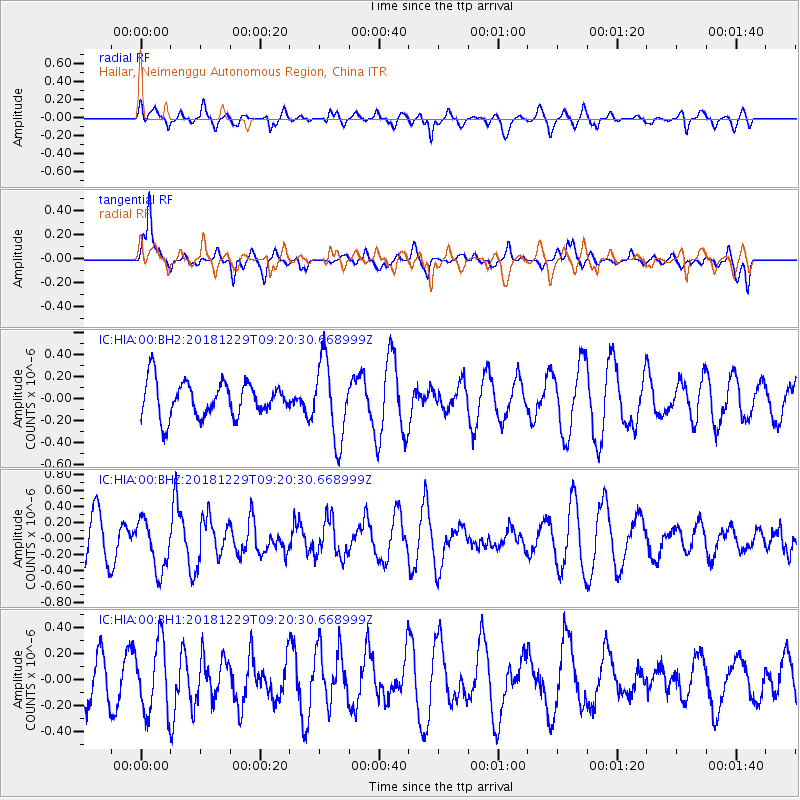
HIA Hailar, Neimenggu Autonomous Region, China - Earthquake Result Viewer
*The percent match for this event was below the threshold and hence no stack was calculated.
| Earthquake location: |
Mindanao, Philippines |
| Earthquake latitude/longitude: |
5.8/126.9 |
| Earthquake time(UTC): |
2018/12/29 (363) 09:13:01 GMT |
| Earthquake Depth: |
62 km |
| Earthquake Magnitude: |
5.3 Mww |
| Earthquake Catalog/Contributor: |
NEIC PDE/us |
|
| Network: |
IC New China Digital Seismograph Network |
| Station: |
HIA Hailar, Neimenggu Autonomous Region, China |
| Lat/Lon: |
49.27 N/119.74 E |
| Elevation: |
620 m |
|
| Distance: |
43.8 deg |
| Az: |
353.192 deg |
| Baz: |
169.626 deg |
| Ray Param: |
$rayparam |
*The percent match for this event was below the threshold and hence was not used in the summary stack. |
|
| Radial Match: |
45.528095 % |
| Radial Bump: |
400 |
| Transverse Match: |
72.529884 % |
| Transverse Bump: |
400 |
| SOD ConfigId: |
3257111 |
| Insert Time: |
2019-01-25 08:33:16.469 +0000 |
| GWidth: |
2.5 |
| Max Bumps: |
400 |
| Tol: |
0.001 |
|
Signal To Noise
| Channel | StoN | STA | LTA |
| IC:HIA:00:BHZ:20181229T09:20:30.668999Z | 1.0832235 | 3.106353E-7 | 2.8676934E-7 |
| IC:HIA:00:BH1:20181229T09:20:30.668999Z | 1.4816495 | 2.7082064E-7 | 1.827832E-7 |
| IC:HIA:00:BH2:20181229T09:20:30.668999Z | 2.245549 | 3.534108E-7 | 1.5738281E-7 |
| Arrivals |
| Ps | |
| PpPs | |
| PsPs/PpSs | |


