You are here: Home > Network List > XA97 - Anatomy of an Archean Craton, South Africa Stations List
> Station SA76 XA.SA76 > Earthquake Result Viewer
SA76 XA.SA76 - Earthquake Result Viewer
| Earthquake location: |
South Sandwich Islands Region |
| Earthquake latitude/longitude: |
-59.7/-29.2 |
| Earthquake time(UTC): |
1997/10/05 (278) 18:04:30 GMT |
| Earthquake Depth: |
274 km |
| Earthquake Magnitude: |
6.0 MB, 6.3 UNKNOWN, 6.3 MW |
| Earthquake Catalog/Contributor: |
WHDF/NEIC |
|
| Network: |
XA Anatomy of an Archean Craton, South Africa |
| Station: |
SA76 XA.SA76 |
| Lat/Lon: |
20.64 S/29.85 E |
| Elevation: |
978 m |
|
| Distance: |
56.9 deg |
| Az: |
73.497 deg |
| Baz: |
211.229 deg |
| Ray Param: |
0.06288965 |
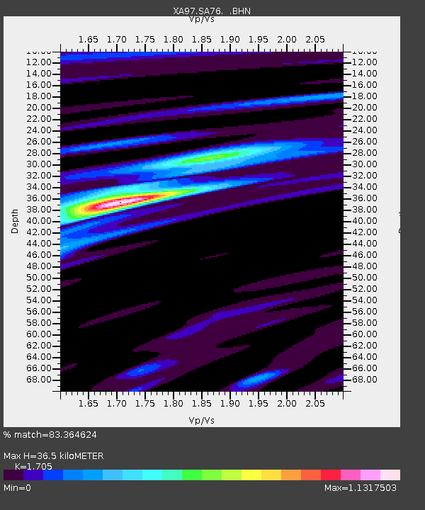
| Estimated Moho Depth: |
36.5 km |
| Estimated Crust Vp/Vs: |
1.71 |
| Assumed Crust Vp: |
6.459 km/s |
| Estimated Crust Vs: |
3.789 km/s |
| Estimated Crust Poisson's Ratio: |
0.24 |
|
| Radial Match: |
83.364624 % |
| Radial Bump: |
374 |
| Transverse Match: |
68.60484 % |
| Transverse Bump: |
400 |
| SOD ConfigId: |
6273 |
| Insert Time: |
2010-02-26 18:31:52.055 +0000 |
| GWidth: |
2.5 |
| Max Bumps: |
400 |
| Tol: |
0.001 |
|
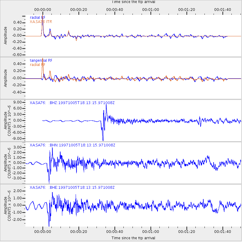
Signal To Noise
| Channel | StoN | STA | LTA |
| XA:SA76: :BHN:19971005T18:13:15.971008Z | 8.749049 | 1.1889123E-6 | 1.3589045E-7 |
| XA:SA76: :BHE:19971005T18:13:15.971008Z | 3.6502655 | 9.374764E-7 | 2.5682417E-7 |
| XA:SA76: :BHZ:19971005T18:13:15.971008Z | 14.469951 | 3.1154655E-6 | 2.1530587E-7 |
| Arrivals |
| Ps | 4.2 SECOND |
| PpPs | 15 SECOND |
| PsPs/PpSs | 19 SECOND |


