
Station XA SA76 - XA.SA76
Network: XA97 - Anatomy of an Archean Craton, South Africa
Nearby stations (2 deg radius)
| Station | Name | (Lat, Lon) | Start / End | Elevation |
| SA76 | XA.SA76 | (-20.64, 29.85) | 1997-04-11 / 1999-12-31 | 978 m |
| Crust2 Type: | G1,Archean, no seds. |
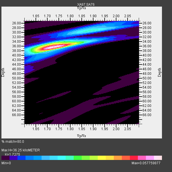
| Thickness Estimate: | 36 km |
| Thickness StdDev: | 0.2 km |
| Vp/Vs Estimate: | 1.73 |
| Vp/Vs StdDev: | 0.01 |
| Vs Estimate: | 3.739 km/s |
| Poisson's Ratio: | 0.25 |
| Peak Value: | 0.06 |
| Assumed Vp: | 6.459 km/s |
| Ps Weight: | 0.33333334 |
| PpPs Weight: | 0.33333334 |
| PsPs Weight: | 0.33333328 |
| Residual Complexity: | 0.434 |
| Nearby stations H: | +- |
| (2.0 deg) Vp/Vs: | +- |
10 with match > 90% ( 28.571428 %) and 13 with match > 80% ( 37.142857 %) out of 35.
Download stack as xyz text file.
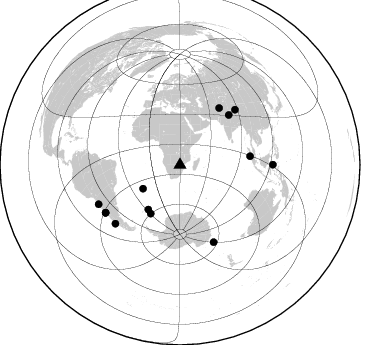
Azimuth Distribution of Events:
Prior Results for this Station
| Study | Thickness | Vp/Vs | Vp | Vs | Poissons Ratio | Extra |
| EARS | 36 km | 1.73 | 6.459 km/s | 3.739 km/s | 0.25 | |
| Crust2.0 | 37 km | 1.76 | 6.459 km/s | 3.665 km/s | 0.26 | G1,Archean, no seds. |
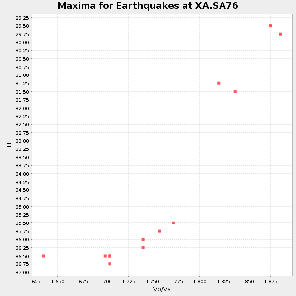
| Global Maxima | 36 km | 1.73 | 6.459 km/s | 3.739 km/s | 0.25 | amp=0.057759877 |
| Local Maxima 1 | 35 km | 1.71 | 6.459 km/s | 3.772 km/s | 0.24 | amp=0.023967016 |
| Local Maxima 2 | 29 km | 1.90 | 6.459 km/s | 3.404 km/s | 0.31 | amp=0.020766443 |
| Local Maxima 3 | 38 km | 1.70 | 6.459 km/s | 3.794 km/s | 0.24 | amp=0.008973007 |
| Local Maxima 4 | 28 km | 1.88 | 6.459 km/s | 3.431 km/s | 0.30 | amp=0.008689539 |
| Predicted Arrivals for vertical incidence (zero ray parameter) | |
| Ps | 4.08 SECOND |
| PpPs | 15.31 SECOND |
| PsPs/PpSs | 19.39 SECOND |
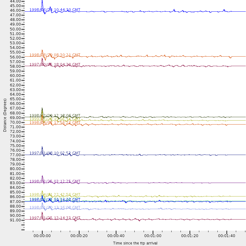
Events Processed for this Station
Download zip of receiver functions as SAC
Plot maxima for each earthquake.
Events Used in the Stack
(13 events)| Radial Match | Distance | Baz | FERegion | Time | Lat/Lon | Depth | Magnitude |
| 98.92785 | 84.3 deg | 156.412 deg | Balleny Islands Region | 1998/03/25 03:12:25 GMT | (-62.9, 149.5) | 10 km | 6.6 MB, 8.0 MS, 8.3 UNKNOWN, 8.1 MW |
| 98.72724 | 69.7 deg | 44.459 deg | Western Xizang-India Border Reg. | 1999/03/28 19:05:11 GMT | (30.5, 79.4) | 15 km | 6.4 MB, 6.6 MS, 6.6 MW, 6.5 ME |
| 97.699684 | 88.6 deg | 237.519 deg | Near Coast Of Central Chile | 1997/10/15 01:03:33 GMT | (-30.9, -71.2) | 58 km | 6.8 MB, 6.8 MS, 7.3 UNKNOWN, 7.1 MW |
| 97.531876 | 70.6 deg | 83.036 deg | Southern Sumatra, Indonesia | 1998/04/01 17:56:23 GMT | (-0.5, 99.3) | 56 km | 6.2 MB, 6.9 MS, 7.0 UNKNOWN, 6.6 ME |
| 97.00094 | 77.7 deg | 45.059 deg | Xizang | 1997/11/08 10:02:52 GMT | (35.1, 87.3) | 33 km | 6.2 MB, 7.9 MS, 7.7 UNKNOWN, 7.6 MW |
| 96.60203 | 87.5 deg | 227.752 deg | Off Coast Of Southern Chile | 1998/04/01 22:42:56 GMT | (-40.3, -74.9) | 9.0 km | 6.2 MB, 6.0 MS, 6.7 UNKNOWN, 6.6 ME |
| 95.60267 | 90.5 deg | 244.309 deg | Near Coast Of Northern Chile | 1998/01/30 12:16:08 GMT | (-23.9, -70.2) | 42 km | 6.3 MB, 6.5 MS, 7.0 UNKNOWN, 6.7 ME |
| 95.35895 | 93.0 deg | 89.787 deg | Minahassa Peninsula, Sulawesi | 1997/11/25 12:14:33 GMT | (1.2, 122.5) | 24 km | 6.1 MB, 6.8 MS, 7.1 UNKNOWN, 6.7 ME |
| 93.595116 | 88.7 deg | 237.407 deg | Near Coast Of Central Chile | 1998/01/12 10:14:07 GMT | (-31.0, -71.4) | 35 km | 5.8 MB, 6.2 MS, 6.6 UNKNOWN, 6.2 ME |
| 91.35451 | 68.9 deg | 34.719 deg | Afghanistan-Tajikistan Bord Reg. | 1998/02/20 12:18:06 GMT | (36.5, 71.1) | 236 km | 5.8 MB, 5.7 MS, 6.4 UNKNOWN, 6.3 MW |
| 89.57143 | 44.1 deg | 237.334 deg | Southern Mid-Atlantic Ridge | 1998/06/24 10:44:30 GMT | (-37.3, -17.4) | 10 km | 5.7 MB, 5.8 MS, 6.0 UNKNOWN, 5.9 MW |
| 85.059235 | 54.7 deg | 215.499 deg | South Sandwich Islands Region | 1998/08/29 08:30:21 GMT | (-55.7, -27.0) | 33 km | 5.6 MB, 5.6 MS, 6.0 UNKNOWN, 5.9 MW |
| 83.364624 | 56.9 deg | 211.229 deg | South Sandwich Islands Region | 1997/10/05 18:04:30 GMT | (-59.7, -29.2) | 274 km | 6.0 MB, 6.3 UNKNOWN, 6.3 MW |
Losers
(22 events)| Radial Match | Distance | Baz | FERegion | Time | Lat/Lon | Depth | Magnitude | Reason |
| 94.38139 | 68.6 deg | 34.581 deg | Hindu Kush Region, Afghanistan | 1997/12/17 05:51:29 GMT | (36.4, 70.8) | 207 km | 5.5 MB, 6.3 UNKNOWN | |
| 79.02094 | 93.8 deg | 85.702 deg | Celebes Sea | 1999/03/04 08:52:01 GMT | (5.4, 121.9) | 33 km | 6.4 MB, 6.5 MS, 7.1 MW, 7.1 MW | |
| 73.49143 | 85.6 deg | 230.881 deg | S. Chile-Argentina Border Region | 1998/12/14 16:25:24 GMT | (-38.2, -71.0) | 138 km | 6.0 UNKNOWN, 4.8 MS, 5.4 MB | |
| 71.71818 | 90.9 deg | 167.597 deg | Balleny Islands Region | 1997/09/23 17:51:23 GMT | (-65.5, 178.8) | 10 km | 5.9 MS, 5.0 MB | |
| 71.156204 | 89.6 deg | 238.872 deg | Near Coast Of Central Chile | 1997/07/19 12:22:57 GMT | (-29.3, -71.7) | 26 km | 5.8 MB, 5.5 MS, 5.9 UNKNOWN, 5.8 MW | |
| 70.8762 | 97.0 deg | 97.449 deg | Banda Sea | 1998/02/19 14:14:51 GMT | (-4.5, 129.1) | 33 km | 6.1 MB, 6.4 MS, 6.5 UNKNOWN, 6.5 MW | |
| 69.50275 | 48.4 deg | 287.444 deg | North Of Ascension Island | 1998/04/10 16:40:38 GMT | (-1.3, -15.7) | 10 km | 5.9 MS, 5.4 MB, 6.2 UNKNOWN, 6.1 MW | |
| 69.3362 | 37.3 deg | 83.13 deg | Mid-Indian Ridge | 1998/04/09 23:26:52 GMT | (-12.2, 67.8) | 10 km | 5.5 MB, 5.4 MS, 5.9 UNKNOWN, 5.9 MW | |
| 67.695045 | 58.2 deg | 81.658 deg | South Indian Ocean | 1999/03/29 06:17:58 GMT | (-4.0, 87.3) | 10 km | 5.5 MS, 5.4 MB, 5.8 MW, 5.8 MW | |
| 65.805756 | 58.5 deg | 351.444 deg | Ionian Sea | 1997/11/18 13:07:41 GMT | (37.6, 20.7) | 33 km | 5.9 MB, 6.4 MS, 6.7 UNKNOWN, 6.1 ML | |
| 65.47021 | 68.7 deg | 76.924 deg | Northern Sumatra, Indonesia | 1999/02/04 19:28:00 GMT | (4.0, 95.3) | 56 km | 5.8 MB, 5.4 MS, 5.9 MW, 5.9 MW | |
| 64.46386 | 90.3 deg | 248.343 deg | Chile-Bolivia Border Region | 1997/12/09 14:23:45 GMT | (-20.2, -68.4) | 133 km | 5.7 MB, 5.7 UNKNOWN, 5.7 MW | |
| 64.433235 | 79.1 deg | 318.074 deg | Azores Islands, Portugal | 1997/06/27 04:39:52 GMT | (38.3, -26.7) | 10 km | 5.6 MB, 5.4 MS, 5.9 UNKNOWN, 5.9 MW | |
| 63.467476 | 89.6 deg | 246.311 deg | Northern Chile | 1997/09/28 23:13:13 GMT | (-22.4, -68.4) | 107 km | 5.7 MB, 5.6 UNKNOWN, 5.6 MW | |
| 63.27387 | 88.3 deg | 99.05 deg | Savu Sea | 1998/11/08 07:25:48 GMT | (-9.1, 121.4) | 33 km | 6.0 MB, 5.9 MS, 6.4 UNKNOWN, 5.7 ME | |
| 61.620464 | 79.6 deg | 92.186 deg | Java Sea | 1997/07/11 09:55:12 GMT | (-5.7, 110.8) | 574 km | 5.6 MB | |
| 61.21479 | 86.7 deg | 151.549 deg | West Of Macquarie Island | 1997/10/17 09:55:15 GMT | (-57.5, 148.0) | 10 km | 5.2 MB, 5.9 MS, 6.2 UNKNOWN, 6.0 MW | |
| 60.957176 | 93.1 deg | 254.183 deg | Peru-Bolivia Border Region | 1997/11/28 22:53:41 GMT | (-13.7, -68.8) | 586 km | 6.4 MB, 6.6 UNKNOWN, 6.6 MW | |
| 59.58581 | 89.4 deg | 237.834 deg | Near Coast Of Central Chile | 1997/07/21 23:19:39 GMT | (-30.3, -71.9) | 33 km | 5.2 MB, 5.5 MS, 6.1 UNKNOWN | |
| 58.63374 | 61.2 deg | 346.967 deg | Southern Italy | 1998/05/18 17:19:04 GMT | (39.3, 15.1) | 280 km | 5.6 MB | |
| 56.252823 | 68.9 deg | 34.652 deg | Afghanistan-Tajikistan Bord Reg. | 1998/12/11 20:16:24 GMT | (36.5, 71.0) | 223 km | 5.7 UNKNOWN, 5.0 MB, 5.6 MW | |
| 50.000572 | 85.0 deg | 95.594 deg | Bali Sea | 1999/03/24 20:32:59 GMT | (-7.0, 117.1) | 621 km | 5.9 MW, 5.3 MB |
