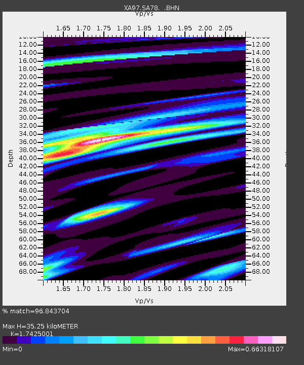
SA78 XA.SA78 - Earthquake Result Viewer
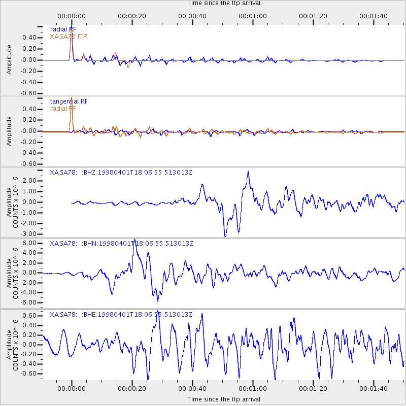
Earthquake location: Southern Sumatra, Indonesia
Earthquake latitude/longitude: -0.5/99.3
Earthquake time(UTC): 1998/04/01 (091) 17:56:23 GMT
Earthquake Depth: 56 km
Earthquake Magnitude: 6.2 MB, 6.9 MS, 7.0 UNKNOWN, 6.6 ME
Earthquake Catalog/Contributor: WHDF/NEIC
Network: XA Anatomy of an Archean Craton, South Africa
Station: SA78 XA.SA78
Lat/Lon: 19.47 S/30.77 E
Elevation: 1401 m
Distance: 69.6 deg
Az: 249.511 deg
Baz: 83.1 deg
Ray Param: 0.055441435
Estimated Moho Depth: 35.25 km
Estimated Crust Vp/Vs: 1.74
Assumed Crust Vp: 6.642 km/s
Estimated Crust Vs: 3.812 km/s
Estimated Crust Poisson's Ratio: 0.25
Radial Match: 96.843704 %
Radial Bump: 246
Transverse Match: 70.98169 %
Transverse Bump: 400
SOD ConfigId: 4480
Insert Time: 2010-02-26 18:33:13.313 +0000
GWidth: 2.5
Max Bumps: 400
Tol: 0.001

Signal To Noise

ChannelStoNSTALTA
XA:SA78: :BHN:19980401T18:06:55.513013Z1.79682963.1518778E-71.7541328E-7
XA:SA78: :BHE:19980401T18:06:55.513013Z1.24491421.5113086E-71.2139863E-7
XA:SA78: :BHZ:19980401T18:06:55.513013Z0.86909667.807322E-88.9832625E-8
Arrivals
Ps4.1 SECOND
PpPs14 SECOND
PsPs/PpSs18 SECOND