
Station XA SA78 - XA.SA78
Network: XA97 - Anatomy of an Archean Craton, South Africa
Nearby stations (2 deg radius)
| Station | Name | (Lat, Lon) | Start / End | Elevation |
| SA78 | XA.SA78 | (-19.47, 30.77) | 1997-04-10 / 1999-12-31 | 1401 m |
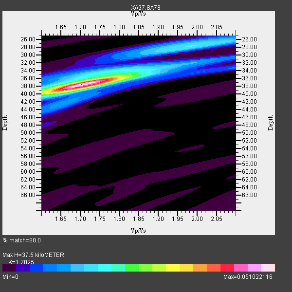
| Crust2 Type: | I1,late Proter., no seds. |
| Thickness Estimate: | 38 km |
| Thickness StdDev: | 0.3 km |
| Vp/Vs Estimate: | 1.70 |
| Vp/Vs StdDev: | 0.02 |
| Vs Estimate: | 3.901 km/s |
| Poisson's Ratio: | 0.24 |
| Peak Value: | 0.05 |
| Assumed Vp: | 6.642 km/s |
| Ps Weight: | 0.33333334 |
| PpPs Weight: | 0.33333334 |
| PsPs Weight: | 0.33333328 |
| Residual Complexity: | 0.467 |
| Nearby stations H: | +- |
| (2.0 deg) Vp/Vs: | +- |
11 with match > 90% ( 32.35294 %) and 15 with match > 80% ( 44.117645 %) out of 34.
Download stack as xyz text file.
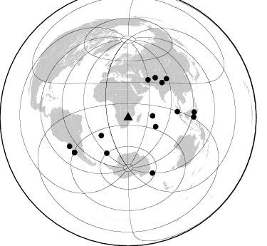
Azimuth Distribution of Events:
Prior Results for this Station
| Study | Thickness | Vp/Vs | Vp | Vs | Poissons Ratio | Extra |
| EARS | 38 km | 1.70 | 6.642 km/s | 3.901 km/s | 0.24 | |
| Crust2.0 | 43 km | 1.77 | 6.642 km/s | 3.756 km/s | 0.26 | I1,late Proter., no seds. |
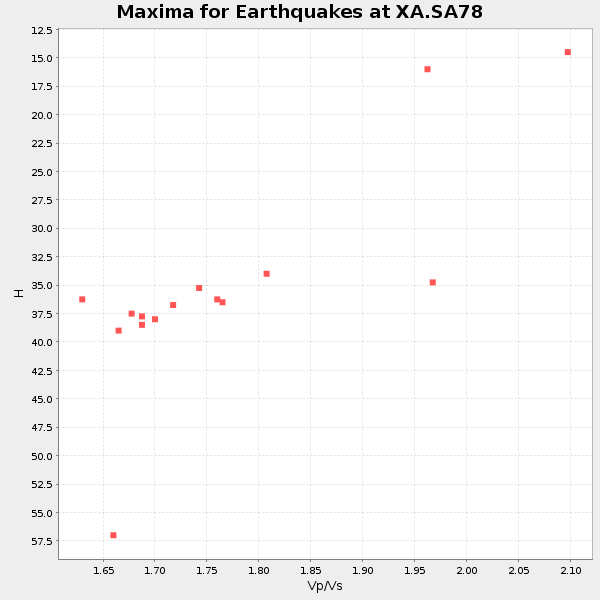
| Global Maxima | 38 km | 1.70 | 6.642 km/s | 3.901 km/s | 0.24 | amp=0.051022116 |
| Local Maxima 1 | 28 km | 2.00 | 6.642 km/s | 3.329 km/s | 0.33 | amp=0.016525377 |
| Local Maxima 2 | 34 km | 1.80 | 6.642 km/s | 3.7 km/s | 0.27 | amp=0.012805523 |
| Local Maxima 3 | 34 km | 1.88 | 6.642 km/s | 3.524 km/s | 0.30 | amp=0.007276057 |
| Local Maxima 4 | 40 km | 1.66 | 6.642 km/s | 4.007 km/s | 0.21 | amp=0.007092356 |
| Predicted Arrivals for vertical incidence (zero ray parameter) | |
| Ps | 3.97 SECOND |
| PpPs | 15.26 SECOND |
| PsPs/PpSs | 19.22 SECOND |
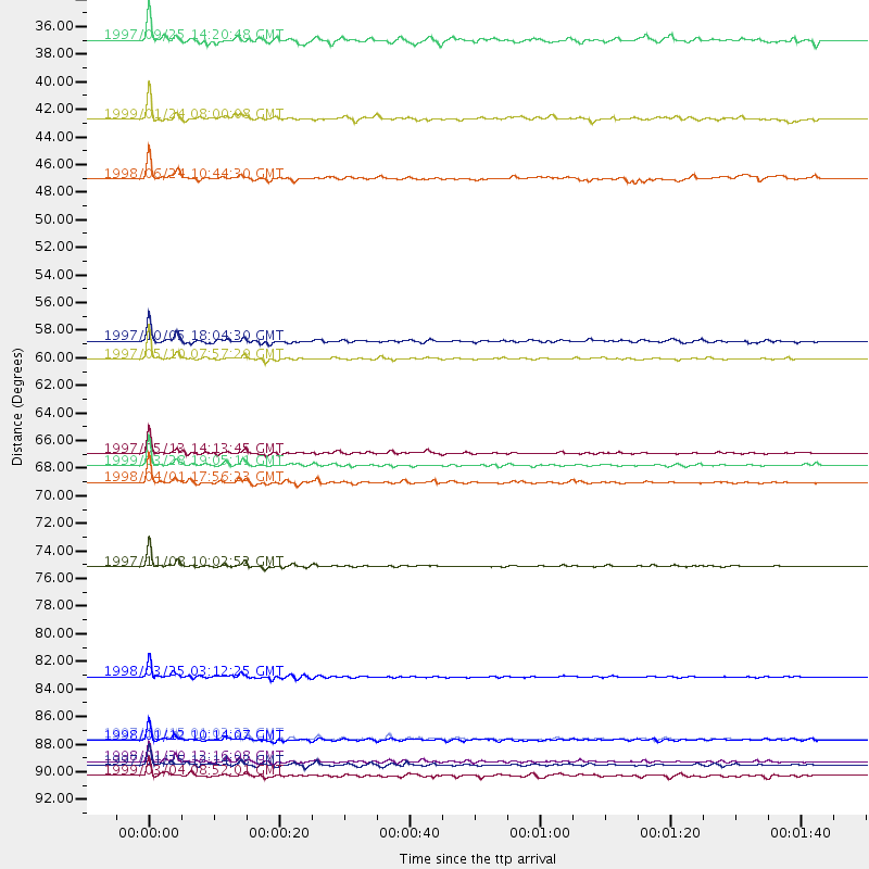
Events Processed for this Station
Download zip of receiver functions as SAC
Plot maxima for each earthquake.
Events Used in the Stack
(15 events)| Radial Match | Distance | Baz | FERegion | Time | Lat/Lon | Depth | Magnitude |
| 98.47537 | 85.0 deg | 156.214 deg | Balleny Islands Region | 1998/03/25 03:12:25 GMT | (-62.9, 149.5) | 10 km | 6.6 MB, 8.0 MS, 8.3 UNKNOWN, 8.1 MW |
| 97.86901 | 76.3 deg | 44.79 deg | Xizang | 1997/11/08 10:02:52 GMT | (35.1, 87.3) | 33 km | 6.2 MB, 7.9 MS, 7.7 UNKNOWN, 7.6 MW |
| 97.83228 | 59.8 deg | 27.876 deg | Northern And Central Iran | 1997/05/10 07:57:29 GMT | (33.8, 59.8) | 10 km | 6.4 MB, 7.3 MS, 7.5 UNKNOWN, 7.2 MW |
| 97.13662 | 89.9 deg | 237.196 deg | Near Coast Of Central Chile | 1997/10/15 01:03:33 GMT | (-30.9, -71.2) | 58 km | 6.8 MB, 6.8 MS, 7.3 UNKNOWN, 7.1 MW |
| 96.843704 | 69.6 deg | 83.1 deg | Southern Sumatra, Indonesia | 1998/04/01 17:56:23 GMT | (-0.5, 99.3) | 56 km | 6.2 MB, 6.9 MS, 7.0 UNKNOWN, 6.6 ME |
| 96.73358 | 68.2 deg | 44.217 deg | Western Xizang-India Border Reg. | 1999/03/28 19:05:11 GMT | (30.5, 79.4) | 15 km | 6.4 MB, 6.6 MS, 6.6 MW, 6.5 ME |
| 95.75755 | 91.8 deg | 244.007 deg | Near Coast Of Northern Chile | 1998/01/30 12:16:08 GMT | (-23.9, -70.2) | 42 km | 6.3 MB, 6.5 MS, 7.0 UNKNOWN, 6.7 ME |
| 95.402245 | 92.1 deg | 89.421 deg | Minahassa Peninsula, Sulawesi | 1997/11/25 12:14:33 GMT | (1.2, 122.5) | 24 km | 6.1 MB, 6.8 MS, 7.1 UNKNOWN, 6.7 ME |
| 94.63074 | 67.3 deg | 34.336 deg | Hindu Kush Region, Afghanistan | 1997/05/13 14:13:45 GMT | (36.4, 70.9) | 196 km | 6.1 MB, 6.5 UNKNOWN, 6.4 MW |
| 93.831276 | 90.1 deg | 237.086 deg | Near Coast Of Central Chile | 1998/01/12 10:14:07 GMT | (-31.0, -71.4) | 35 km | 5.8 MB, 6.2 MS, 6.6 UNKNOWN, 6.2 ME |
| 90.93392 | 40.7 deg | 108.19 deg | Mid-Indian Ridge | 1999/01/24 08:00:08 GMT | (-26.5, 74.5) | 10 km | 6.0 MB, 6.3 MS, 6.3 MW, 6.3 ME |
| 88.18079 | 45.4 deg | 236.514 deg | Southern Mid-Atlantic Ridge | 1998/06/24 10:44:30 GMT | (-37.3, -17.4) | 10 km | 5.7 MB, 5.8 MS, 6.0 UNKNOWN, 5.9 MW |
| 87.93302 | 58.3 deg | 211.005 deg | South Sandwich Islands Region | 1997/10/05 18:04:30 GMT | (-59.7, -29.2) | 274 km | 6.0 MB, 6.3 UNKNOWN, 6.3 MW |
| 85.0967 | 34.4 deg | 86.032 deg | Mid-Indian Ridge | 1997/09/25 14:20:48 GMT | (-13.8, 66.2) | 10 km | 5.3 MB, 5.7 MS, 6.0 UNKNOWN, 6.0 MW |
| 83.27882 | 92.9 deg | 85.322 deg | Celebes Sea | 1999/03/04 08:52:01 GMT | (5.4, 121.9) | 33 km | 6.4 MB, 6.5 MS, 7.1 MW, 7.1 MW |
Losers
(19 events)| Radial Match | Distance | Baz | FERegion | Time | Lat/Lon | Depth | Magnitude | Reason |
| 79.6584 | 87.6 deg | 98.781 deg | Savu Sea | 1998/11/08 07:25:48 GMT | (-9.1, 121.4) | 33 km | 6.0 MB, 5.9 MS, 6.4 UNKNOWN, 5.7 ME | |
| 77.23663 | 96.3 deg | 96.986 deg | Banda Sea | 1998/02/19 14:14:51 GMT | (-4.5, 129.1) | 33 km | 6.1 MB, 6.4 MS, 6.5 UNKNOWN, 6.5 MW | |
| 75.02335 | 47.2 deg | 129.237 deg | Mid-Indian Ridge | 1997/08/20 13:51:16 GMT | (-41.7, 80.1) | 10 km | 5.6 MB, 6.4 MS, 6.5 UNKNOWN, 6.4 MW | |
| 73.52455 | 55.9 deg | 212.543 deg | South Sandwich Islands Region | 1997/06/02 21:24:38 GMT | (-57.8, -25.5) | 33 km | 5.9 MB, 5.8 MS, 6.1 UNKNOWN, 6.1 MW | |
| 72.4721 | 67.4 deg | 33.295 deg | Afghanistan-Tajikistan Bord Reg. | 1998/05/30 06:22:28 GMT | (37.1, 70.1) | 33 km | 5.9 MB, 6.9 MS, 6.6 UNKNOWN, 6.5 MW | |
| 71.16948 | 56.2 deg | 4.375 deg | Turkey | 1998/06/27 13:55:52 GMT | (36.9, 35.3) | 33 km | 5.8 MB, 6.2 MS, 6.3 UNKNOWN, 6.3 ME | |
| 70.47487 | 48.9 deg | 285.927 deg | North Of Ascension Island | 1998/04/10 16:40:38 GMT | (-1.3, -15.7) | 10 km | 5.9 MS, 5.4 MB, 6.2 UNKNOWN, 6.1 MW | |
| 69.61767 | 90.6 deg | 237.364 deg | Near Coast Of Central Chile | 1997/07/27 05:21:29 GMT | (-30.5, -71.9) | 33 km | 5.6 MB, 5.8 MS, 6.3 UNKNOWN, 6.2 MW | |
| 69.11097 | 78.8 deg | 317.479 deg | Azores Islands, Portugal | 1997/06/27 04:39:52 GMT | (38.3, -26.7) | 10 km | 5.6 MB, 5.4 MS, 5.9 UNKNOWN, 5.9 MW | |
| 67.16466 | 87.0 deg | 230.543 deg | S. Chile-Argentina Border Region | 1998/12/14 16:25:24 GMT | (-38.2, -71.0) | 138 km | 6.0 UNKNOWN, 4.8 MS, 5.4 MB | |
| 66.7678 | 78.7 deg | 92.1 deg | Java Sea | 1997/07/11 09:55:12 GMT | (-5.7, 110.8) | 574 km | 5.6 MB | |
| 62.828262 | 72.8 deg | 35.731 deg | Southern Xinjiang, China | 1997/04/11 05:34:42 GMT | (39.5, 76.9) | 15 km | 5.8 MB, 6.1 MS, 6.1 UNKNOWN, 5.8 ME | |
| 62.07296 | 67.5 deg | 76.985 deg | Northern Sumatra, Indonesia | 1999/02/04 19:28:00 GMT | (4.0, 95.3) | 56 km | 5.8 MB, 5.4 MS, 5.9 MW, 5.9 MW | |
| 58.317406 | 91.0 deg | 238.559 deg | Near Coast Of Central Chile | 1997/07/19 12:22:57 GMT | (-29.3, -71.7) | 26 km | 5.8 MB, 5.5 MS, 5.9 UNKNOWN, 5.8 MW | |
| 58.127243 | 96.6 deg | 88.251 deg | Talaud Islands, Indonesia | 1998/09/28 19:23:23 GMT | (3.8, 126.4) | 30 km | 5.8 MB, 5.9 MS, 6.2 UNKNOWN, 6.1 MW | |
| 50.00356 | 89.5 deg | 235.906 deg | Near Coast Of Central Chile | 1998/07/29 07:14:24 GMT | (-32.3, -71.3) | 51 km | 6.3 MB, 6.5 UNKNOWN, 6.5 ME | |
| 49.4304 | 68.0 deg | 73.327 deg | Nicobar Islands, India Region | 1998/08/10 09:52:14 GMT | (7.3, 94.3) | 33 km | 5.9 MB, 5.8 MS, 6.0 UNKNOWN | |
| 49.358074 | 98.2 deg | 84.29 deg | Mindanao, Philippines | 1997/09/15 13:05:42 GMT | (8.1, 126.6) | 51 km | 5.8 MB, 5.7 MS, 6.1 UNKNOWN, 6.1 MW | |
| 48.217266 | 97.4 deg | 86.882 deg | Mindanao, Philippines | 1998/09/02 08:37:29 GMT | (5.4, 126.8) | 50 km | 6.6 MB, 6.7 MS, 6.8 UNKNOWN, 6.8 ME |
