You are here: Home > Network List > XA97 - Anatomy of an Archean Craton, South Africa Stations List
> Station SA78 XA.SA78 > Earthquake Result Viewer
SA78 XA.SA78 - Earthquake Result Viewer
| Earthquake location: |
South Sandwich Islands Region |
| Earthquake latitude/longitude: |
-59.7/-29.2 |
| Earthquake time(UTC): |
1997/10/05 (278) 18:04:30 GMT |
| Earthquake Depth: |
274 km |
| Earthquake Magnitude: |
6.0 MB, 6.3 UNKNOWN, 6.3 MW |
| Earthquake Catalog/Contributor: |
WHDF/NEIC |
|
| Network: |
XA Anatomy of an Archean Craton, South Africa |
| Station: |
SA78 XA.SA78 |
| Lat/Lon: |
19.47 S/30.77 E |
| Elevation: |
1401 m |
|
| Distance: |
58.3 deg |
| Az: |
73.668 deg |
| Baz: |
211.005 deg |
| Ray Param: |
0.061960764 |
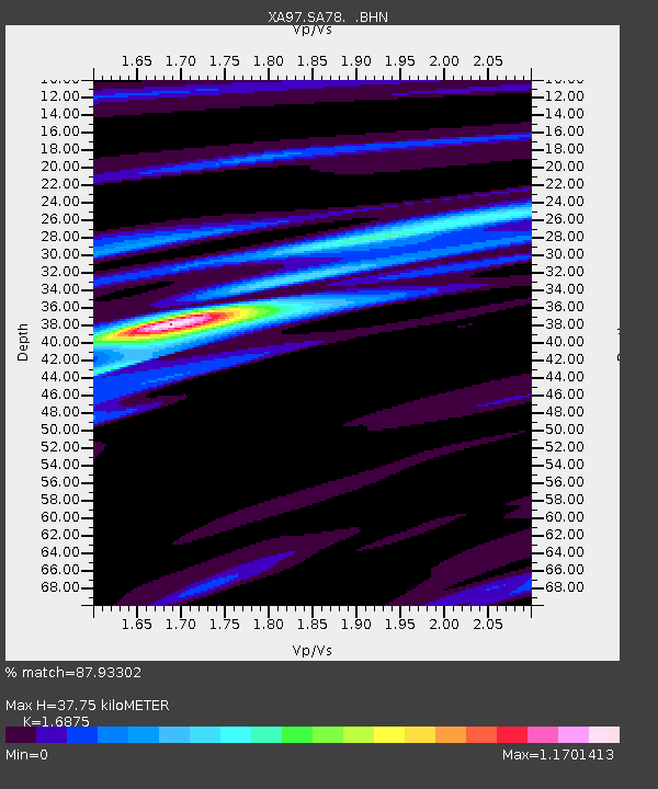
| Estimated Moho Depth: |
37.75 km |
| Estimated Crust Vp/Vs: |
1.69 |
| Assumed Crust Vp: |
6.642 km/s |
| Estimated Crust Vs: |
3.936 km/s |
| Estimated Crust Poisson's Ratio: |
0.23 |
|
| Radial Match: |
87.93302 % |
| Radial Bump: |
380 |
| Transverse Match: |
58.410427 % |
| Transverse Bump: |
400 |
| SOD ConfigId: |
6273 |
| Insert Time: |
2010-02-26 18:33:17.651 +0000 |
| GWidth: |
2.5 |
| Max Bumps: |
400 |
| Tol: |
0.001 |
|
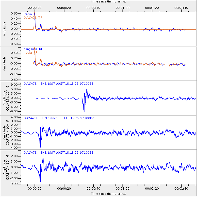
Signal To Noise
| Channel | StoN | STA | LTA |
| XA:SA78: :BHN:19971005T18:13:25.971008Z | 6.4417644 | 1.1874115E-6 | 1.8433016E-7 |
| XA:SA78: :BHE:19971005T18:13:25.971008Z | 5.2304177 | 9.439203E-7 | 1.8046748E-7 |
| XA:SA78: :BHZ:19971005T18:13:25.971008Z | 11.085634 | 3.1233433E-6 | 2.817469E-7 |
| Arrivals |
| Ps | 4.1 SECOND |
| PpPs | 14 SECOND |
| PsPs/PpSs | 19 SECOND |


