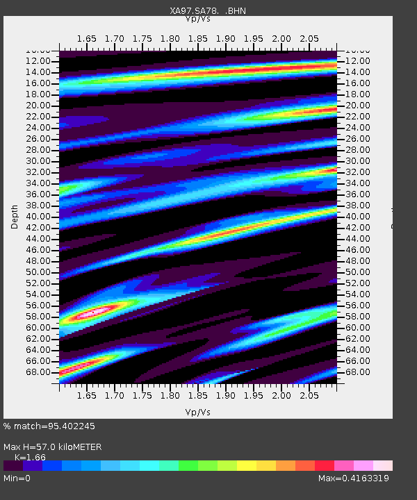
SA78 XA.SA78 - Earthquake Result Viewer
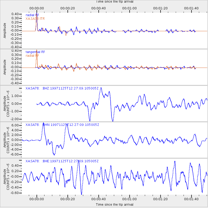
Earthquake location: Minahassa Peninsula, Sulawesi
Earthquake latitude/longitude: 1.2/122.5
Earthquake time(UTC): 1997/11/25 (329) 12:14:33 GMT
Earthquake Depth: 24 km
Earthquake Magnitude: 6.1 MB, 6.8 MS, 7.1 UNKNOWN, 6.7 ME
Earthquake Catalog/Contributor: WHDF/NEIC
Network: XA Anatomy of an Archean Craton, South Africa
Station: SA78 XA.SA78
Lat/Lon: 19.47 S/30.77 E
Elevation: 1401 m
Distance: 92.1 deg
Az: 250.683 deg
Baz: 89.421 deg
Ray Param: 0.041508667
Estimated Moho Depth: 57.0 km
Estimated Crust Vp/Vs: 1.66
Assumed Crust Vp: 6.642 km/s
Estimated Crust Vs: 4.001 km/s
Estimated Crust Poisson's Ratio: 0.22
Radial Match: 95.402245 %
Radial Bump: 300
Transverse Match: 77.873886 %
Transverse Bump: 400
SOD ConfigId: 4480
Insert Time: 2010-02-26 18:33:25.743 +0000
GWidth: 2.5
Max Bumps: 400
Tol: 0.001

Signal To Noise

ChannelStoNSTALTA
XA:SA78: :BHN:19971125T12:27:09.105005Z15.687213.081729E-61.964485E-7
XA:SA78: :BHE:19971125T12:27:09.105005Z0.64769657.2744655E-81.12312875E-7
XA:SA78: :BHZ:19971125T12:27:09.105005Z7.4602129.40277E-71.2603891E-7
Arrivals
Ps5.8 SECOND
PpPs22 SECOND
PsPs/PpSs28 SECOND