You are here: Home > Network List > SP - South Carolina Earth Physics Project Stations List
> Station TRLBY Terrell's Bay High School, Marion County, SC USA > Earthquake Result Viewer
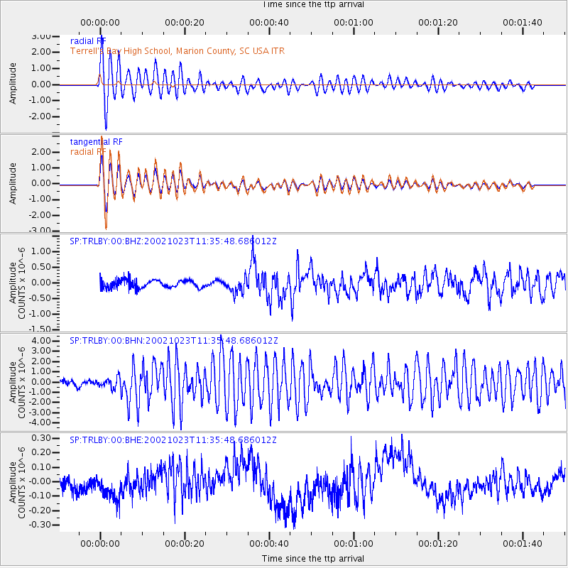
TRLBY Terrell's Bay High School, Marion County, SC USA - Earthquake Result Viewer
*The percent match for this event was below the threshold and hence no stack was calculated.
| Earthquake location: |
Central Alaska |
| Earthquake latitude/longitude: |
63.5/-147.9 |
| Earthquake time(UTC): |
2002/10/23 (296) 11:27:19 GMT |
| Earthquake Depth: |
4.2 km |
| Earthquake Magnitude: |
6.0 MB, 6.7 MS, 6.7 MW, 6.7 MW |
| Earthquake Catalog/Contributor: |
WHDF/NEIC |
|
| Network: |
SP South Carolina Earth Physics Project |
| Station: |
TRLBY Terrell's Bay High School, Marion County, SC USA |
| Lat/Lon: |
34.03 N/79.36 W |
| Elevation: |
15 m |
|
| Distance: |
50.7 deg |
| Az: |
91.606 deg |
| Baz: |
327.338 deg |
| Ray Param: |
$rayparam |
*The percent match for this event was below the threshold and hence was not used in the summary stack. |
|
| Radial Match: |
93.25408 % |
| Radial Bump: |
400 |
| Transverse Match: |
91.40018 % |
| Transverse Bump: |
400 |
| SOD ConfigId: |
2277 |
| Insert Time: |
2010-02-25 19:32:07.345 +0000 |
| GWidth: |
2.5 |
| Max Bumps: |
400 |
| Tol: |
0.001 |
|
Signal To Noise
| Channel | StoN | STA | LTA |
| SP:TRLBY:00:BHN:20021023T11:35:48.686012Z | 1.5649155 | 4.995636E-7 | 3.192272E-7 |
| SP:TRLBY:00:BHE:20021023T11:35:48.686012Z | 1.3916292 | 1.0889628E-7 | 7.825093E-8 |
| SP:TRLBY:00:BHZ:20021023T11:35:48.686012Z | 1.7888244 | 2.2889893E-7 | 1.2796053E-7 |
| Arrivals |
| Ps | |
| PpPs | |
| PsPs/PpSs | |


