You are here: Home > Network List > SP - South Carolina Earth Physics Project Stations List
> Station TRLBY Terrell's Bay High School, Marion County, SC USA > Earthquake Result Viewer
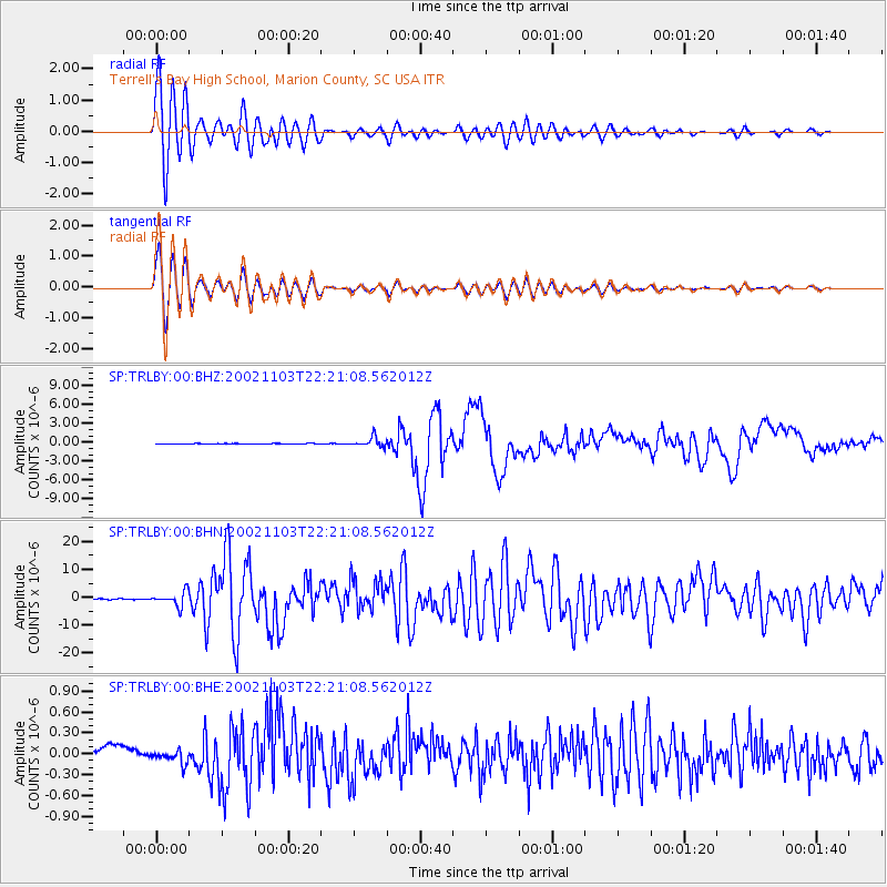
TRLBY Terrell's Bay High School, Marion County, SC USA - Earthquake Result Viewer
*The percent match for this event was below the threshold and hence no stack was calculated.
| Earthquake location: |
Central Alaska |
| Earthquake latitude/longitude: |
63.5/-147.4 |
| Earthquake time(UTC): |
2002/11/03 (307) 22:12:41 GMT |
| Earthquake Depth: |
4.9 km |
| Earthquake Magnitude: |
7.0 MB, 8.5 MS, 7.9 MW |
| Earthquake Catalog/Contributor: |
WHDF/NEIC |
|
| Network: |
SP South Carolina Earth Physics Project |
| Station: |
TRLBY Terrell's Bay High School, Marion County, SC USA |
| Lat/Lon: |
34.03 N/79.36 W |
| Elevation: |
15 m |
|
| Distance: |
50.4 deg |
| Az: |
92.033 deg |
| Baz: |
327.351 deg |
| Ray Param: |
$rayparam |
*The percent match for this event was below the threshold and hence was not used in the summary stack. |
|
| Radial Match: |
90.309586 % |
| Radial Bump: |
400 |
| Transverse Match: |
90.08485 % |
| Transverse Bump: |
400 |
| SOD ConfigId: |
2277 |
| Insert Time: |
2010-02-25 19:32:07.950 +0000 |
| GWidth: |
2.5 |
| Max Bumps: |
400 |
| Tol: |
0.001 |
|
Signal To Noise
| Channel | StoN | STA | LTA |
| SP:TRLBY:00:BHN:20021103T22:21:08.562012Z | 13.056025 | 2.5899092E-6 | 1.983689E-7 |
| SP:TRLBY:00:BHE:20021103T22:21:08.562012Z | 1.1895888 | 9.31002E-8 | 7.82625E-8 |
| SP:TRLBY:00:BHZ:20021103T22:21:08.562012Z | 28.162043 | 7.575005E-7 | 2.6897926E-8 |
| Arrivals |
| Ps | |
| PpPs | |
| PsPs/PpSs | |


