You are here: Home > Network List > XA97 - Anatomy of an Archean Craton, South Africa Stations List
> Station SA79 XA.SA79 > Earthquake Result Viewer
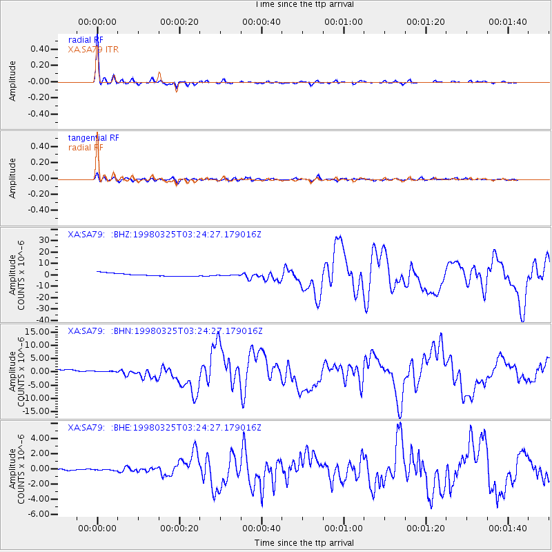
SA79 XA.SA79 - Earthquake Result Viewer

| Earthquake location: |
Balleny Islands Region |
| Earthquake latitude/longitude: |
-62.9/149.5 |
| Earthquake time(UTC): |
1998/03/25 (084) 03:12:25 GMT |
| Earthquake Depth: |
10 km |
| Earthquake Magnitude: |
6.6 MB, 8.0 MS, 8.3 UNKNOWN, 8.1 MW |
| Earthquake Catalog/Contributor: |
WHDF/NEIC |
|
| Network: |
XA Anatomy of an Archean Craton, South Africa |
| Station: |
SA79 XA.SA79 |
| Lat/Lon: |
20.02 S/30.52 E |
| Elevation: |
1078 m |
|
| Distance: |
84.6 deg |
| Az: |
235.685 deg |
| Baz: |
156.26 deg |
| Ray Param: |
0.04534098 |
| Estimated Moho Depth: |
39.5 km |
| Estimated Crust Vp/Vs: |
1.66 |
| Assumed Crust Vp: |
6.642 km/s |
| Estimated Crust Vs: |
3.995 km/s |
| Estimated Crust Poisson's Ratio: |
0.22 |
|
| Radial Match: |
97.68406 % |
| Radial Bump: |
263 |
| Transverse Match: |
81.50173 % |
| Transverse Bump: |
400 |
| SOD ConfigId: |
6273 |
| Insert Time: |
2010-02-26 18:33:46.322 +0000 |
| GWidth: |
2.5 |
| Max Bumps: |
400 |
| Tol: |
0.001 |
|
Signal To Noise
| Channel | StoN | STA | LTA |
| XA:SA79: :BHN:19980325T03:24:27.179016Z | 0.43148625 | 3.627931E-7 | 8.407987E-7 |
| XA:SA79: :BHE:19980325T03:24:27.179016Z | 0.30918515 | 2.1711807E-7 | 7.022267E-7 |
| XA:SA79: :BHZ:19980325T03:24:27.179016Z | 0.28602985 | 3.588218E-7 | 1.2544908E-6 |
| Arrivals |
| Ps | 4.1 SECOND |
| PpPs | 15 SECOND |
| PsPs/PpSs | 19 SECOND |


