
Station XA SA79 - XA.SA79
Network: XA97 - Anatomy of an Archean Craton, South Africa
Nearby stations (2 deg radius)
| Station | Name | (Lat, Lon) | Start / End | Elevation |
| SA79 | XA.SA79 | (-20.02, 30.52) | 1997-04-11 / 1999-12-31 | 1078 m |
| Crust2 Type: | I1,late Proter., no seds. |
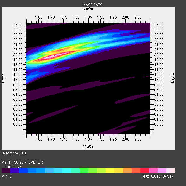
| Thickness Estimate: | 38 km |
| Thickness StdDev: | 1.5 km |
| Vp/Vs Estimate: | 1.71 |
| Vp/Vs StdDev: | 0.03 |
| Vs Estimate: | 3.878 km/s |
| Poisson's Ratio: | 0.24 |
| Peak Value: | 0.04 |
| Assumed Vp: | 6.642 km/s |
| Ps Weight: | 0.33333334 |
| PpPs Weight: | 0.33333334 |
| PsPs Weight: | 0.33333328 |
| Residual Complexity: | 0.555 |
| Nearby stations H: | +- |
| (2.0 deg) Vp/Vs: | +- |
4 with match > 90% ( 14.814815 %) and 8 with match > 80% ( 29.62963 %) out of 27.
Download stack as xyz text file.
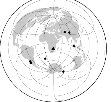
Azimuth Distribution of Events:
Prior Results for this Station
| Study | Thickness | Vp/Vs | Vp | Vs | Poissons Ratio | Extra |
| EARS | 38 km | 1.71 | 6.642 km/s | 3.878 km/s | 0.24 | |
| Crust2.0 | 43 km | 1.77 | 6.642 km/s | 3.756 km/s | 0.26 | I1,late Proter., no seds. |
| Global Maxima | 38 km | 1.71 | 6.642 km/s | 3.878 km/s | 0.24 | amp=0.042484947 |
| Local Maxima 1 | 36 km | 1.73 | 6.642 km/s | 3.839 km/s | 0.25 | amp=0.026005605 |
| Local Maxima 2 | 33 km | 1.86 | 6.642 km/s | 3.576 km/s | 0.30 | amp=0.014784526 |
| Local Maxima 3 | 41 km | 1.64 | 6.642 km/s | 4.038 km/s | 0.21 | amp=0.011260118 |
| Local Maxima 4 | 32 km | 1.81 | 6.642 km/s | 3.67 km/s | 0.28 | amp=0.0100720525 |
| Predicted Arrivals for vertical incidence (zero ray parameter) | |
| Ps | 4.10 SECOND |
| PpPs | 15.62 SECOND |
| PsPs/PpSs | 19.72 SECOND |
Events Processed for this Station
Download zip of receiver functions as SAC
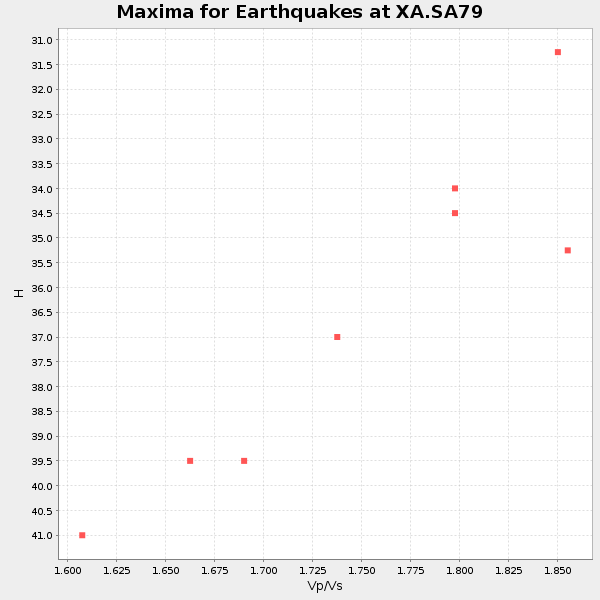
Plot maxima for each earthquake.
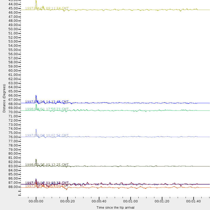
Events Used in the Stack
(8 events)| Radial Match | Distance | Baz | FERegion | Time | Lat/Lon | Depth | Magnitude |
| 97.68406 | 84.6 deg | 156.26 deg | Balleny Islands Region | 1998/03/25 03:12:25 GMT | (-62.9, 149.5) | 10 km | 6.6 MB, 8.0 MS, 8.3 UNKNOWN, 8.1 MW |
| 96.97076 | 89.4 deg | 237.284 deg | Near Coast Of Central Chile | 1997/10/15 01:03:33 GMT | (-30.9, -71.2) | 58 km | 6.8 MB, 6.8 MS, 7.3 UNKNOWN, 7.1 MW |
| 96.65458 | 67.9 deg | 34.375 deg | Hindu Kush Region, Afghanistan | 1997/05/13 14:13:45 GMT | (36.4, 70.9) | 196 km | 6.1 MB, 6.5 UNKNOWN, 6.4 MW |
| 93.91507 | 76.8 deg | 44.824 deg | Xizang | 1997/11/08 10:02:52 GMT | (35.1, 87.3) | 33 km | 6.2 MB, 7.9 MS, 7.7 UNKNOWN, 7.6 MW |
| 88.22707 | 69.9 deg | 82.995 deg | Southern Sumatra, Indonesia | 1998/04/01 17:56:23 GMT | (-0.5, 99.3) | 56 km | 6.2 MB, 6.9 MS, 7.0 UNKNOWN, 6.6 ME |
| 85.69989 | 43.1 deg | 219.411 deg | Southern Mid-Atlantic Ridge | 1997/04/25 09:11:34 GMT | (-48.3, -10.0) | 10 km | 5.8 MS, 5.3 MB, 5.8 UNKNOWN, 5.7 MW |
| 82.95855 | 90.3 deg | 237.865 deg | Near Coast Of Central Chile | 1997/07/06 09:54:00 GMT | (-30.1, -71.9) | 19 km | 5.8 MB, 6.5 MS, 6.8 UNKNOWN, 6.4 ME |
| 80.93475 | 89.5 deg | 241.332 deg | Northern Chile | 1997/05/17 02:10:18 GMT | (-27.2, -69.5) | 106 km | 5.5 MB, 5.6 UNKNOWN, 5.5 MW |
Losers
(19 events)| Radial Match | Distance | Baz | FERegion | Time | Lat/Lon | Depth | Magnitude | Reason |
| 97.66431 | 89.3 deg | 221.84 deg | Off Coast Of Southern Chile | 1998/01/19 18:23:59 GMT | (-45.0, -79.5) | 10 km | 5.5 MS, 5.4 MB, 6.2 UNKNOWN, 6.2 MW | |
| 80.96551 | 51.3 deg | 286.512 deg | North Of Ascension Island | 1998/03/29 07:14:58 GMT | (-0.2, -17.9) | 10 km | 5.5 MB, 5.6 MS, 6.1 UNKNOWN, 6.1 MW | |
| 79.30474 | 68.0 deg | 33.347 deg | Afghanistan-Tajikistan Bord Reg. | 1998/02/04 14:33:21 GMT | (37.1, 70.1) | 33 km | 5.6 MB, 6.1 MS, 6.0 UNKNOWN, 5.9 MW | |
| 78.28844 | 92.3 deg | 89.527 deg | Minahassa Peninsula, Sulawesi | 1997/11/25 12:14:33 GMT | (1.2, 122.5) | 24 km | 6.1 MB, 6.8 MS, 7.1 UNKNOWN, 6.7 ME | |
| 71.938736 | 73.5 deg | 35.728 deg | Southern Xinjiang, China | 1997/04/15 18:19:10 GMT | (39.6, 77.0) | 23 km | 5.8 MS, 5.4 MB, 5.9 UNKNOWN, 5.7 MW | |
| 66.976395 | 48.8 deg | 286.534 deg | North Of Ascension Island | 1998/04/10 16:40:38 GMT | (-1.3, -15.7) | 10 km | 5.9 MS, 5.4 MB, 6.2 UNKNOWN, 6.1 MW | |
| 66.57913 | 79.0 deg | 317.672 deg | Azores Islands, Portugal | 1997/06/27 04:39:52 GMT | (38.3, -26.7) | 10 km | 5.6 MB, 5.4 MS, 5.9 UNKNOWN, 5.9 MW | |
| 64.39178 | 89.6 deg | 237.172 deg | Near Coast Of Central Chile | 1998/01/12 10:14:07 GMT | (-31.0, -71.4) | 35 km | 5.8 MB, 6.2 MS, 6.6 UNKNOWN, 6.2 ME | |
| 63.219444 | 67.8 deg | 34.28 deg | Hindu Kush Region, Afghanistan | 1997/12/17 05:51:29 GMT | (36.4, 70.8) | 207 km | 5.5 MB, 6.3 UNKNOWN | |
| 61.60731 | 79.0 deg | 92.075 deg | Java Sea | 1997/07/11 09:55:12 GMT | (-5.7, 110.8) | 574 km | 5.6 MB | |
| 60.309105 | 64.6 deg | 50.864 deg | Southern India | 1997/05/21 22:51:28 GMT | (23.1, 80.0) | 36 km | 6.0 MB, 5.6 MS, 5.8 UNKNOWN, 5.6 ME | |
| 60.28896 | 90.4 deg | 246.079 deg | Northern Chile | 1997/09/28 23:13:13 GMT | (-22.4, -68.4) | 107 km | 5.7 MB, 5.6 UNKNOWN, 5.6 MW | |
| 60.221966 | 56.0 deg | 350.709 deg | Central Mediterranean Sea | 1997/07/27 10:07:52 GMT | (35.6, 21.1) | 33 km | 5.5 MB, 4.8 MS, 5.6 UNKNOWN, 5.2 ML | |
| 59.56654 | 96.4 deg | 90.095 deg | Northern Molucca Sea | 1997/09/17 14:50:35 GMT | (2.1, 126.6) | 33 km | 5.7 MB, 5.5 MS, 6.2 UNKNOWN, 5.9 MW | |
| 59.132412 | 88.0 deg | 93.26 deg | Sulawesi, Indonesia | 1997/09/28 01:38:28 GMT | (-3.8, 119.7) | 33 km | 5.6 MB, 5.5 MS, 5.9 UNKNOWN, 5.9 MW | |
| 58.98182 | 91.3 deg | 244.082 deg | Near Coast Of Northern Chile | 1998/01/30 12:16:08 GMT | (-23.9, -70.2) | 42 km | 6.3 MB, 6.5 MS, 7.0 UNKNOWN, 6.7 ME | |
| 54.792274 | 78.5 deg | 57.558 deg | Myanmar | 1997/12/30 13:43:18 GMT | (25.4, 96.6) | 33 km | 5.7 MS, 5.4 MB, 5.7 UNKNOWN, 5.7 MW | |
| 52.3329 | 96.1 deg | 97.955 deg | Banda Sea | 1997/09/26 15:48:34 GMT | (-5.4, 129.0) | 254 km | 5.8 MB, 6.0 UNKNOWN, 6.0 MW | |
| 47.28259 | 91.1 deg | 248.116 deg | Chile-Bolivia Border Region | 1997/12/09 14:23:45 GMT | (-20.2, -68.4) | 133 km | 5.7 MB, 5.7 UNKNOWN, 5.7 MW |
