You are here: Home > Network List > SP - South Carolina Earth Physics Project Stations List
> Station TRLBY Terrell's Bay High School, Marion County, SC USA > Earthquake Result Viewer
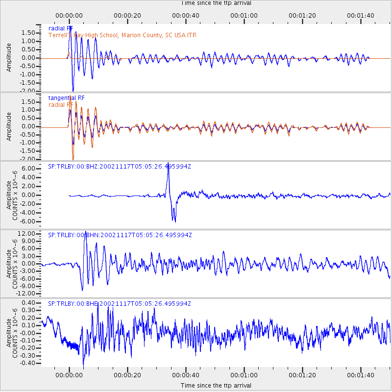
TRLBY Terrell's Bay High School, Marion County, SC USA - Earthquake Result Viewer
*The percent match for this event was below the threshold and hence no stack was calculated.
| Earthquake location: |
Northwest Of Kuril Islands |
| Earthquake latitude/longitude: |
47.8/146.2 |
| Earthquake time(UTC): |
2002/11/17 (321) 04:53:53 GMT |
| Earthquake Depth: |
459 km |
| Earthquake Magnitude: |
7.3 MW, 7.3 MW |
| Earthquake Catalog/Contributor: |
WHDF/NEIC |
|
| Network: |
SP South Carolina Earth Physics Project |
| Station: |
TRLBY Terrell's Bay High School, Marion County, SC USA |
| Lat/Lon: |
34.03 N/79.36 W |
| Elevation: |
15 m |
|
| Distance: |
88.9 deg |
| Az: |
36.382 deg |
| Baz: |
331.229 deg |
| Ray Param: |
$rayparam |
*The percent match for this event was below the threshold and hence was not used in the summary stack. |
|
| Radial Match: |
83.81817 % |
| Radial Bump: |
400 |
| Transverse Match: |
83.68487 % |
| Transverse Bump: |
400 |
| SOD ConfigId: |
2277 |
| Insert Time: |
2010-02-25 19:32:10.237 +0000 |
| GWidth: |
2.5 |
| Max Bumps: |
400 |
| Tol: |
0.001 |
|
Signal To Noise
| Channel | StoN | STA | LTA |
| SP:TRLBY:00:BHN:20021117T05:05:26.495994Z | 4.762575 | 3.4159684E-6 | 7.172524E-7 |
| SP:TRLBY:00:BHE:20021117T05:05:26.495994Z | 2.5028527 | 1.9105421E-7 | 7.633458E-8 |
| SP:TRLBY:00:BHZ:20021117T05:05:26.495994Z | 20.370228 | 2.1262708E-6 | 1.043813E-7 |
| Arrivals |
| Ps | |
| PpPs | |
| PsPs/PpSs | |


