You are here: Home > Network List > TA - USArray Transportable Network (new EarthScope stations) Stations List
> Station 034A Hebronville, TX, USA > Earthquake Result Viewer
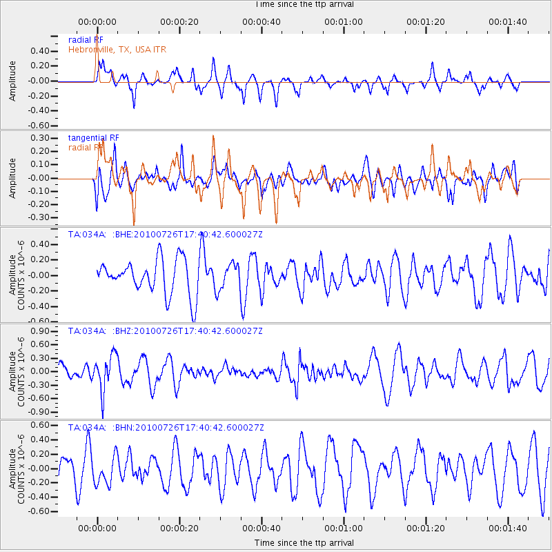
034A Hebronville, TX, USA - Earthquake Result Viewer
*The percent match for this event was below the threshold and hence no stack was calculated.
| Earthquake location: |
Salta Province, Argentina |
| Earthquake latitude/longitude: |
-24.1/-66.8 |
| Earthquake time(UTC): |
2010/07/26 (207) 17:31:31 GMT |
| Earthquake Depth: |
193 km |
| Earthquake Magnitude: |
5.6 MW, 5.3 MB, 5.5 MW |
| Earthquake Catalog/Contributor: |
WHDF/NEIC |
|
| Network: |
TA USArray Transportable Network (new EarthScope stations) |
| Station: |
034A Hebronville, TX, USA |
| Lat/Lon: |
27.06 N/98.68 W |
| Elevation: |
155 m |
|
| Distance: |
59.4 deg |
| Az: |
326.853 deg |
| Baz: |
145.905 deg |
| Ray Param: |
$rayparam |
*The percent match for this event was below the threshold and hence was not used in the summary stack. |
|
| Radial Match: |
52.826538 % |
| Radial Bump: |
388 |
| Transverse Match: |
48.89295 % |
| Transverse Bump: |
400 |
| SOD ConfigId: |
319893 |
| Insert Time: |
2011-01-05 13:05:51.041 +0000 |
| GWidth: |
2.5 |
| Max Bumps: |
400 |
| Tol: |
0.001 |
|
Signal To Noise
| Channel | StoN | STA | LTA |
| TA:034A: :BHZ:20100726T17:40:42.600027Z | 1.9989388 | 4.0318884E-7 | 2.0170144E-7 |
| TA:034A: :BHN:20100726T17:40:42.600027Z | 0.96570075 | 1.9635154E-7 | 2.0332546E-7 |
| TA:034A: :BHE:20100726T17:40:42.600027Z | 0.7392528 | 1.6627712E-7 | 2.2492593E-7 |
| Arrivals |
| Ps | |
| PpPs | |
| PsPs/PpSs | |


