
Station TA 034A - Hebronville, TX, USA
Network: TA - USArray Transportable Network (new EarthScope stations)
Nearby stations (2 deg radius)
| Station | Name | (Lat, Lon) | Start / End | Elevation |
| 034A | Hebronville, TX, USA | (27.06, -98.68) | 2010-01-08 / 2599-12-31 | 155 m |
| Crust2 Type: | L6,continental arc, Cordilleras, 7.0 km seds. |
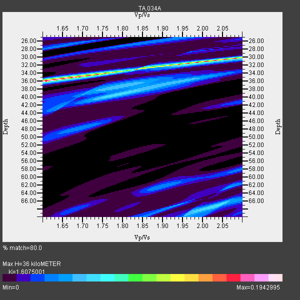
| Thickness Estimate: | 36 km |
| Thickness StdDev: | 1.3 km |
| Vp/Vs Estimate: | 1.61 |
| Vp/Vs StdDev: | 0.10 |
| Vs Estimate: | 3.792 km/s |
| Poisson's Ratio: | 0.18 |
| Peak Value: | 0.19 |
| Assumed Vp: | 6.096 km/s |
| Ps Weight: | 0.33333334 |
| PpPs Weight: | 0.33333334 |
| PsPs Weight: | 0.33333328 |
| Residual Complexity: | 0.745 |
| Nearby stations H: | +- |
| (2.0 deg) Vp/Vs: | +- |
1 with match > 90% ( 3.2258065 %) and 2 with match > 80% ( 6.451613 %) out of 31.
Download stack as xyz text file.
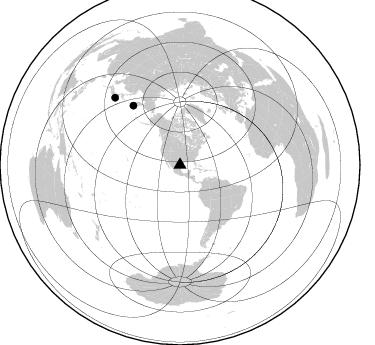
Azimuth Distribution of Events:
Prior Results for this Station
| Study | Thickness | Vp/Vs | Vp | Vs | Poissons Ratio | Extra |
| EARS | 36 km | 1.61 | 6.096 km/s | 3.792 km/s | 0.18 | |
| Crust2.0 | 35 km | 1.77 | 6.096 km/s | 3.439 km/s | 0.27 | L6,continental arc, Cordilleras, 7.0 km seds. |
| Global Maxima | 36 km | 1.61 | 6.096 km/s | 3.792 km/s | 0.18 | amp=0.1942995 |
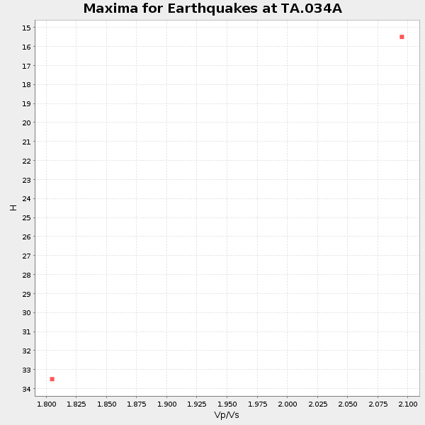
| Local Maxima 1 | 31 km | 2.01 | 6.096 km/s | 3.033 km/s | 0.34 | amp=0.12333665 |
| Local Maxima 2 | 33 km | 1.84 | 6.096 km/s | 3.322 km/s | 0.29 | amp=0.07749326 |
| Local Maxima 3 | 67 km | 2.05 | 6.096 km/s | 2.981 km/s | 0.34 | amp=0.06988911 |
| Local Maxima 4 | 67 km | 1.94 | 6.096 km/s | 3.142 km/s | 0.32 | amp=0.049423452 |
| Predicted Arrivals for vertical incidence (zero ray parameter) | |
| Ps | 3.59 SECOND |
| PpPs | 15.40 SECOND |
| PsPs/PpSs | 18.99 SECOND |
Events Processed for this Station
Download zip of receiver functions as SAC
Plot maxima for each earthquake.
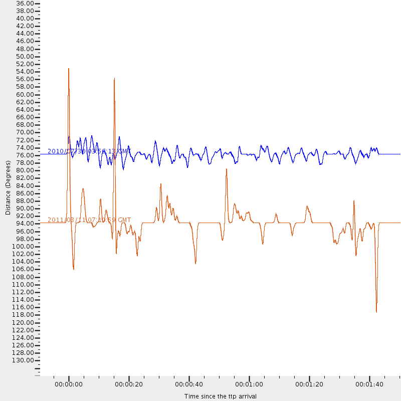
Events Used in the Stack
(2 events)| Radial Match | Distance | Baz | FERegion | Time | Lat/Lon | Depth | Magnitude |
| 93.09914 | 93.5 deg | 315.907 deg | Off East Coast Of Honshu, Japan | 2011/03/11 07:10:59 GMT | (37.9, 142.7) | 34 km | 5.8 MB |
| 84.13197 | 75.5 deg | 321.775 deg | Off East Coast Of Kamchatka | 2010/07/30 03:56:13 GMT | (52.5, 159.8) | 23 km | 6.1 MB, 6.3 MS, 6.3 MW, 6.3 MW |
Losers
(29 events)| Radial Match | Distance | Baz | FERegion | Time | Lat/Lon | Depth | Magnitude | Reason |
| 84.78482 | 69.3 deg | 158.9 deg | Near Coast Of Central Chile | 2011/01/02 20:20:17 GMT | (-38.4, -73.3) | 24 km | 6.6 MB, 7.1 MS, 7.1 MW, 7.0 MW | |
| 82.99192 | 93.6 deg | 314.392 deg | Off East Coast Of Honshu, Japan | 2011/03/11 07:01:11 GMT | (36.6, 143.8) | 36 km | 5.7 MB | |
| 80.4135 | 63.5 deg | 144.522 deg | Santiago Del Estero Prov., Arg. | 2011/01/01 09:56:58 GMT | (-26.8, -63.1) | 577 km | 6.8 MB, 7.0 MW, 7.0 MW | |
| 79.63715 | 66.1 deg | 155.906 deg | Near Coast Of Central Chile | 2010/03/11 14:39:43 GMT | (-34.3, -71.9) | 11 km | 6.7 MB, 7.0 MS, 6.9 MW, 6.9 MW | |
| 78.78887 | 67.0 deg | 157.635 deg | Off Coast Of Central Chile | 2010/03/15 11:08:28 GMT | (-35.8, -73.2) | 14 km | 5.9 MB, 6.1 MS, 6.2 MW, 6.1 MW | |
| 78.25584 | 57.1 deg | 145.959 deg | Northern Chile | 2010/07/12 00:11:21 GMT | (-22.1, -68.2) | 115 km | 6.1 MB, 6.3 MW, 6.2 MW | |
| 76.83381 | 57.6 deg | 317.178 deg | Fox Islands, Aleutian Islands | 2010/07/18 19:48:04 GMT | (52.8, -169.7) | 10 km | 5.6 MB, 5.6 MS, 6.0 MW, 6.0 MW | |
| 75.19094 | 60.9 deg | 151.76 deg | Near Coast Of Northern Chile | 2010/03/26 14:52:07 GMT | (-28.0, -70.8) | 42 km | 6.2 MB, 5.9 MS, 6.3 MW, 6.1 MW | |
| 74.09046 | 92.9 deg | 314.719 deg | Off East Coast Of Honshu, Japan | 2011/03/11 06:49:16 GMT | (37.3, 144.2) | 47 km | 6.1 MB | |
| 72.980095 | 85.3 deg | 247.953 deg | Tonga Islands | 2010/09/04 08:52:04 GMT | (-17.4, -174.0) | 69 km | 5.9 MB, 6.1 MW, 6.0 MW | |
| 71.8429 | 57.1 deg | 146.115 deg | Northern Chile | 2010/03/04 22:39:26 GMT | (-22.2, -68.3) | 114 km | 6.3 MB, 6.4 MW, 6.3 MW | |
| 67.3983 | 65.3 deg | 155.891 deg | Off Coast Of Central Chile | 2010/03/10 12:20:58 GMT | (-33.6, -72.3) | 35 km | 5.5 MB, 5.5 MS | |
| 65.779816 | 66.0 deg | 155.9 deg | Near Coast Of Central Chile | 2010/03/12 16:50:01 GMT | (-34.2, -71.9) | 7.0 km | 6.1 MB, 5.4 MS, 5.8 MW, 5.7 MW | |
| 64.81129 | 65.3 deg | 21.182 deg | Jan Mayen Island Region | 2011/01/29 06:55:26 GMT | (70.9, -6.7) | 6.0 km | 6.1 MB, 6.1 MS, 6.2 MW, 6.2 MW | |
| 63.630043 | 82.5 deg | 93.723 deg | North Of Ascension Island | 2011/02/12 02:53:15 GMT | (0.1, -17.0) | 10 km | 5.5 MB, 5.6 MW | |
| 63.43844 | 89.2 deg | 248.03 deg | Fiji Islands Region | 2010/06/22 22:16:20 GMT | (-19.2, -177.6) | 562 km | 5.8 MW, 5.1 MB, 5.8 MW | |
| 62.451942 | 87.2 deg | 244.279 deg | Tonga Islands | 2010/02/22 05:08:49 GMT | (-21.5, -173.8) | 33 km | 5.8 MB, 5.3 MS, 5.7 MW, 5.7 MW | |
| 61.51532 | 57.4 deg | 316.991 deg | Fox Islands, Aleutian Islands | 2010/07/28 11:31:46 GMT | (52.7, -169.4) | 10 km | 5.6 MW, 5.2 MS, 5.2 MB, 5.1 ML | |
| 61.329563 | 88.8 deg | 163.068 deg | Drake Passage | 2010/01/17 12:00:01 GMT | (-57.7, -65.9) | 5.0 km | 6.0 MB, 6.0 MS, 6.3 MW, 6.3 MW | |
| 60.221027 | 72.9 deg | 324.453 deg | Near East Coast Of Kamchatka | 2011/02/20 21:43:24 GMT | (55.9, 162.1) | 33 km | 6.1 MB, 5.9 MS, 6.2 MW, 5.9 MW | |
| 59.059486 | 68.8 deg | 158.636 deg | Near Coast Of Central Chile | 2010/06/29 01:40:00 GMT | (-37.8, -73.3) | 17 km | 6.0 MB, 5.2 MS, 5.5 MW, 6.1 ML | |
| 58.31069 | 57.4 deg | 316.974 deg | Fox Islands, Aleutian Islands | 2010/07/19 08:20:30 GMT | (52.7, -169.3) | 10 km | 5.6 MW, 5.2 MS, 5.4 MB, 5.1 ML | |
| 57.432384 | 92.6 deg | 317.481 deg | Near East Coast Of Honshu, Japan | 2010/07/04 21:55:51 GMT | (39.7, 142.4) | 27 km | 6.4 MB, 6.1 MS, 6.3 MW, 6.2 MW | |
| 54.08908 | 83.8 deg | 249.723 deg | Tonga Islands | 2010/07/25 03:39:17 GMT | (-15.1, -173.5) | 7.0 km | 5.6 MB, 5.7 MS, 5.9 MW, 5.9 MW | |
| 53.663494 | 49.5 deg | 143.429 deg | Central Peru | 2010/09/13 07:15:49 GMT | (-14.6, -70.8) | 180 km | 5.6 MB, 5.9 MW, 5.8 MW | |
| 53.297 | 79.7 deg | 320.798 deg | Kuril Islands | 2010/07/25 12:57:01 GMT | (49.7, 154.6) | 130 km | 5.7 MB, 5.6 MW, 5.6 MW | |
| 52.826538 | 59.4 deg | 145.905 deg | Salta Province, Argentina | 2010/07/26 17:31:31 GMT | (-24.1, -66.8) | 193 km | 5.6 MW, 5.3 MB, 5.5 MW | |
| 52.335007 | 88.4 deg | 245.702 deg | Tonga Islands | 2011/02/12 17:57:56 GMT | (-20.9, -175.7) | 90 km | 6.0 MB, 6.1 MW, 6.1 MW | |
| 50.40901 | 94.8 deg | 315.41 deg | Near East Coast Of Honshu, Japan | 2011/03/11 07:09:58 GMT | (36.7, 141.9) | 35 km | 5.6 MB |
