You are here: Home > Network List > TX - Texas Seismological Network Stations List
> Station MB21 Endeavor > Earthquake Result Viewer
MB21 Endeavor - Earthquake Result Viewer
| Earthquake location: |
Andreanof Islands, Aleutian Is. |
| Earthquake latitude/longitude: |
52.4/-176.9 |
| Earthquake time(UTC): |
2023/10/16 (289) 11:35:31 GMT |
| Earthquake Depth: |
187 km |
| Earthquake Magnitude: |
6.4 Mww |
| Earthquake Catalog/Contributor: |
NEIC PDE/us |
|
| Network: |
TX Texas Seismological Network |
| Station: |
MB21 Endeavor |
| Lat/Lon: |
32.34 N/101.73 W |
| Elevation: |
999 m |
|
| Distance: |
56.4 deg |
| Az: |
79.337 deg |
| Baz: |
314.714 deg |
| Ray Param: |
0.063580506 |
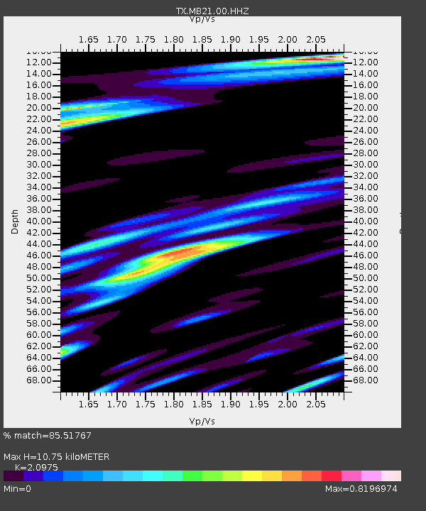
| Estimated Moho Depth: |
10.75 km |
| Estimated Crust Vp/Vs: |
2.10 |
| Assumed Crust Vp: |
6.426 km/s |
| Estimated Crust Vs: |
3.064 km/s |
| Estimated Crust Poisson's Ratio: |
0.35 |
|
| Radial Match: |
85.51767 % |
| Radial Bump: |
400 |
| Transverse Match: |
70.24695 % |
| Transverse Bump: |
400 |
| SOD ConfigId: |
31937991 |
| Insert Time: |
2023-10-30 12:37:42.500 +0000 |
| GWidth: |
2.5 |
| Max Bumps: |
400 |
| Tol: |
0.001 |
|

Signal To Noise
| Channel | StoN | STA | LTA |
| TX:MB21:00:HHZ:20231016T11:44:22.512011Z | 17.576578 | 5.7647912E-6 | 3.279814E-7 |
| TX:MB21:00:HHN:20231016T11:44:22.512011Z | 8.177743 | 1.8942328E-6 | 2.3163271E-7 |
| TX:MB21:00:HHE:20231016T11:44:22.512011Z | 7.8799667 | 1.7550219E-6 | 2.2271946E-7 |
| Arrivals |
| Ps | 1.9 SECOND |
| PpPs | 5.0 SECOND |
| PsPs/PpSs | 6.9 SECOND |


