You are here: Home > Network List > XG92 - Rocky Mountain Front Stations List
> Station BLA Blanca, CO > Earthquake Result Viewer
BLA Blanca, CO - Earthquake Result Viewer
| Earthquake location: |
Northern Peru |
| Earthquake latitude/longitude: |
-3.9/-76.6 |
| Earthquake time(UTC): |
1992/07/13 (195) 18:11:34 GMT |
| Earthquake Depth: |
100 km |
| Earthquake Magnitude: |
6.2 MB |
| Earthquake Catalog/Contributor: |
WHDF/NEIC |
|
| Network: |
XG Rocky Mountain Front |
| Station: |
BLA Blanca, CO |
| Lat/Lon: |
37.54 N/105.57 W |
| Elevation: |
2744 m |
|
| Distance: |
49.3 deg |
| Az: |
329.481 deg |
| Baz: |
140.402 deg |
| Ray Param: |
0.06849798 |
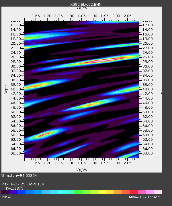
| Estimated Moho Depth: |
27.25 km |
| Estimated Crust Vp/Vs: |
1.94 |
| Assumed Crust Vp: |
6.316 km/s |
| Estimated Crust Vs: |
3.26 km/s |
| Estimated Crust Poisson's Ratio: |
0.32 |
|
| Radial Match: |
94.63364 % |
| Radial Bump: |
400 |
| Transverse Match: |
95.07469 % |
| Transverse Bump: |
400 |
| SOD ConfigId: |
3286 |
| Insert Time: |
2010-02-25 20:07:03.308 +0000 |
| GWidth: |
2.5 |
| Max Bumps: |
400 |
| Tol: |
0.001 |
|

Signal To Noise
| Channel | StoN | STA | LTA |
| XG:BLA:02:BHN:19920713T18:19:41.94101Z | 26.318537 | 0.0015908214 | 6.0444905E-5 |
| XG:BLA:02:BHE:19920713T18:19:41.94101Z | 13.112531 | 8.382467E-4 | 6.392715E-5 |
| XG:BLA:02:BHZ:19920713T18:19:41.94101Z | 53.21649 | 0.0033357777 | 6.268316E-5 |
| Arrivals |
| Ps | 4.3 SECOND |
| PpPs | 12 SECOND |
| PsPs/PpSs | 16 SECOND |


