
Station XG BLA - Blanca, CO
Network: XG92 - Rocky Mountain Front
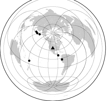
Nearby stations (2 deg radius)
| Station | Name | (Lat, Lon) | Start / End | Elevation |
| BLA | Blanca, CO | (37.54, -105.57) | 1992-05-23 / 2499-01-01 | 2.7 km |
| Crust2 Type: | PC,orogen/45km, Orogen, 1 km seds. |
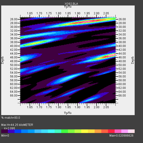
| Thickness Estimate: | 44 km |
| Thickness StdDev: | 9.3 km |
| Vp/Vs Estimate: | 2.10 |
| Vp/Vs StdDev: | 0.16 |
| Vs Estimate: | 3.015 km/s |
| Poisson's Ratio: | 0.35 |
| Peak Value: | 0.02 |
| Assumed Vp: | 6.316 km/s |
| Ps Weight: | 0.33333334 |
| PpPs Weight: | 0.33333334 |
| PsPs Weight: | 0.33333328 |
| Residual Complexity: | 0.866 |
| Nearby stations H: | +- |
| (2.0 deg) Vp/Vs: | +- |
5 with match > 90% ( 83.333336 %) and 6 with match > 80% ( 100.0 %) out of 6.
Download stack as xyz text file.
Azimuth Distribution of Events:
Prior Results for this Station
| Study | Thickness | Vp/Vs | Vp | Vs | Poissons Ratio | Extra |
| EARS | 44 km | 2.10 | 6.316 km/s | 3.015 km/s | 0.35 | |
| Crust2.0 | 45 km | 1.76 | 6.316 km/s | 3.587 km/s | 0.26 | PC,orogen/45km, Orogen, 1 km seds. |
| Global Maxima | 44 km | 2.10 | 6.316 km/s | 3.015 km/s | 0.35 | amp=0.020986626 |
| Local Maxima 1 | 27 km | 1.94 | 6.316 km/s | 3.26 km/s | 0.32 | amp=0.019221641 |
| Local Maxima 2 | 38 km | 1.67 | 6.316 km/s | 3.776 km/s | 0.22 | amp=0.012936808 |
| Local Maxima 3 | 48 km | 1.60 | 6.316 km/s | 3.947 km/s | 0.18 | amp=0.010760851 |
| Local Maxima 4 | 36 km | 1.60 | 6.316 km/s | 3.947 km/s | 0.18 | amp=0.010389354 |
| Predicted Arrivals for vertical incidence (zero ray parameter) | |
| Ps | 7.67 SECOND |
| PpPs | 21.69 SECOND |
| PsPs/PpSs | 29.36 SECOND |
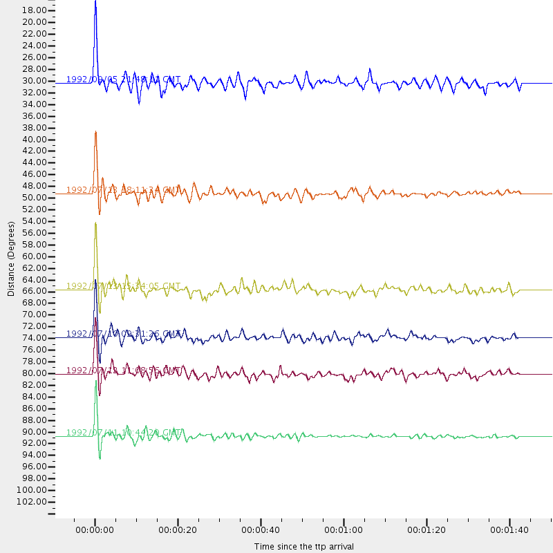
Events Processed for this Station
Download zip of receiver functions as SAC
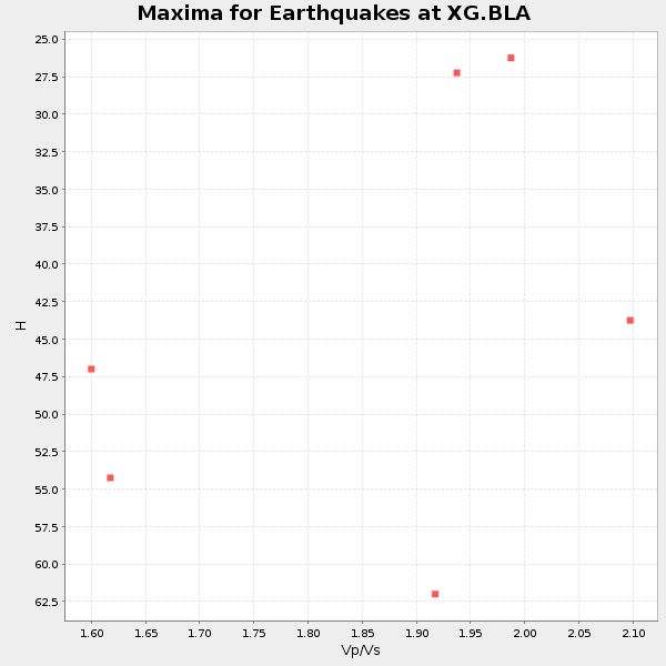
Plot maxima for each earthquake.
Events Used in the Stack
(6 events)| Radial Match | Distance | Baz | FERegion | Time | Lat/Lon | Depth | Magnitude |
| 96.175064 | 65.6 deg | 316.651 deg | Near East Coast Of Kamchatka | 1992/07/13 15:34:05 GMT | (51.2, 157.7) | 53 km | 5.7 MB |
| 95.03511 | 80.1 deg | 315.105 deg | Hokkaido, Japan Region | 1992/07/12 11:08:56 GMT | (41.4, 142.1) | 70 km | 5.9 MB |
| 94.63364 | 49.3 deg | 140.402 deg | Northern Peru | 1992/07/13 18:11:34 GMT | (-3.9, -76.6) | 100 km | 6.2 MB |
| 94.41128 | 90.7 deg | 242.311 deg | South Of Fiji Islands | 1992/07/11 10:44:20 GMT | (-22.3, -178.5) | 381 km | 6.2 MB |
| 91.15569 | 73.8 deg | 314.109 deg | Kuril Islands | 1992/07/10 09:31:26 GMT | (44.7, 149.5) | 11 km | 6.1 MB, 6.5 MS |
| 88.18449 | 30.3 deg | 142.576 deg | Near Coast Of Nicaragua | 1992/09/05 21:48:11 GMT | (12.0, -87.3) | 10 km | 5.1 MB, 5.9 MS |
Losers
(0 events)| Radial Match | Distance | Baz | FERegion | Time | Lat/Lon | Depth | Magnitude | Reason |
