You are here: Home > Network List > JP - Japan Meteorological Agency Seismic Network Stations List
> Station JEM Erimo > Earthquake Result Viewer
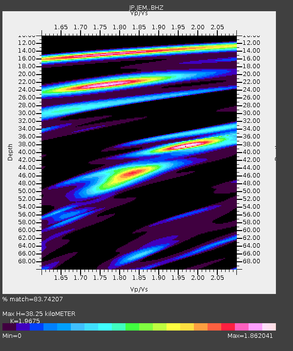
JEM Erimo - Earthquake Result Viewer
| Earthquake location: |
Banda Sea |
| Earthquake latitude/longitude: |
-6.1/129.9 |
| Earthquake time(UTC): |
2023/11/08 (312) 13:02:06 GMT |
| Earthquake Depth: |
10 km |
| Earthquake Magnitude: |
6.7 mww |
| Earthquake Catalog/Contributor: |
NEIC PDE/us |
|
| Network: |
JP Japan Meteorological Agency Seismic Network |
| Station: |
JEM Erimo |
| Lat/Lon: |
42.02 N/143.15 E |
| Elevation: |
40 m |
|
| Distance: |
49.4 deg |
| Az: |
12.983 deg |
| Baz: |
197.444 deg |
| Ray Param: |
0.06871984 |
| Estimated Moho Depth: |
38.25 km |
| Estimated Crust Vp/Vs: |
1.97 |
| Assumed Crust Vp: |
6.461 km/s |
| Estimated Crust Vs: |
3.284 km/s |
| Estimated Crust Poisson's Ratio: |
0.33 |
|
| Radial Match: |
83.74207 % |
| Radial Bump: |
400 |
| Transverse Match: |
80.81223 % |
| Transverse Bump: |
400 |
| SOD ConfigId: |
31937991 |
| Insert Time: |
2023-11-22 13:10:25.547 +0000 |
| GWidth: |
2.5 |
| Max Bumps: |
400 |
| Tol: |
0.001 |
|

Signal To Noise
| Channel | StoN | STA | LTA |
| JP:JEM: :BHZ:20231108T13:10:40.000024Z | 1.7882713 | 9.094502E-7 | 5.0856386E-7 |
| JP:JEM: :BHN:20231108T13:10:40.000024Z | 1.6691241 | 5.6801446E-7 | 3.403069E-7 |
| JP:JEM: :BHE:20231108T13:10:40.000024Z | 1.1298746 | 5.564867E-7 | 4.925208E-7 |
| Arrivals |
| Ps | 6.0 SECOND |
| PpPs | 17 SECOND |
| PsPs/PpSs | 23 SECOND |


